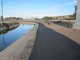
The Arizona Canal Trail is one of the longer multi-use trails in Maricopa County, running between Phoenix and Peoria along both sides of the Arizona Canal. The closest access point to downtown Phoenix is ~9 miles north. A section runs through central Scottsdale. The trail connects to a number of other trails along its route, including the New River Trail, the Cave Creek Trail, and the Skunk Creek Trail. This trail is one of the most trafficked for running and will also include many cyclists, as there are numerous underpaths and very little auto traffic to deal with. Combination paved and gravel. This wonderful interactive map has path details and the opportunity to calculate segment distances. Note: there are no street lights on this trail if running at night.
- 35.9 miles total -- so choose your segment!
- Any point along path
- Numerous access points - see interactive map. A cross-cut trail connects from Tempe


Comment on this Route/Share a Photo!
Share your feedback on this route and see that of other Great Runs users. Click on the image icon to upload a photo. And please let us know if there are notes or changes we should incorporate!