Features:
Categories:
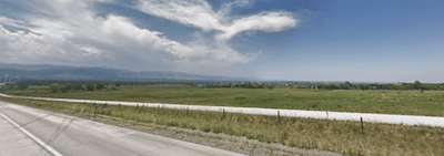
If you want something long, flat, and open, the new US 36 Bikeway is a good running option. This is a relatively new paved bike path that runs from the south end of Boulder to Westminster for 16 miles. The surrounding views are nice, but since the path follows hard by the Boulder Turnpike, it’s not exactly quiet or bucolic. It’s really more of a bicycle commuter path.
The closest start point to Boulder is Table Mesa in South Boulder, where a pedestrian bridge crosses over the turnpike onto the trail. Run as far as you like for up to 16 miles to 80th Ave. in Westminster. Key distances and landmarks:
- First 3 miles heading east are through the Davidson Mesa Open Space (connect to additional trails). Steep climb heading east, miles 1.5-3.0
- 5 miles: Coal Creek
- 6.3 miles: Hodgson-Harris Reservoir, Frank Varra Park
- 8 miles: Trails at Carolyn Holmberg Preserve at Rock Creek Farm
- 9.3 miles: Interlocken East Park
- 12.5 miles: Butterfly Garden, Westminster City Park. Climb at mile 12.8
- 16.5 miles: Westminster Hills Park, eastern terminus
There’s continued work to expand this path as far as Denver.
Essentials
- Up to 16 miles (26 km)
- 890 feet over 16 miles. Steepest part is miles 1.5-3.0 from the western end
- West end: Table Mesa Rd. in south Boulder; East End: 80th St. in Westminster

Comment on this Route/Share a Photo!
Share your feedback on this route and see that of other Great Runs users. Click on the image icon to upload a photo. And please let us know if there are notes or changes we should incorporate!