Features:
Categories:
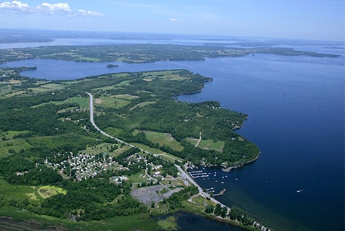
The Lake Champlain Islands, located just north of Burlington, are a runner’s paradise. Quiet country roads pass by farms, with views of Lake Champlain, the Green Mountains, and the Adirondacks. The islands/sections include, from north to south: the Alburgh area; Isle La Motte; North Hero; Grand Isle, and South Hero. Note that at the southern tip of South Hero, a seasonal bike ferry connects the 200 foot gap to the Colchester Causeway and the Island Line Trail — itself a fabulous run! Here are a few suggested routes, which can be mixed and matched depending on desired distance. Note: Roads except for Rt. 2 have no shoulder but are traffic-free. Rt. 2 is busier but has a wide shoulder.
PRETTIEST SECTIONS
- Alburgh: W Shore Rd. Just south of Alburgh Center, a gorgeous, traffic-free road along Lake Champlain, with great views. 4.8 miles one-way, including causeway to Isle La Motte. ROUTE MAP
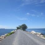
- Isle La Motte: W Shore Rd. Up to 5 miles of gorgeous waterfront running. Full island loop is 10 miles, using Main St. for the return — lovely farmland landscape. ROUTE MAP
- Grand Isle: from Knight Point State Park to Mary Crest Beach using E Shore N Rd. ROUTE MAP
- South Hero: Sections of W Shore Rd.

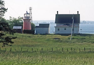
Isle La Motte. Mark Lowenstein

ROUTE SUGGESTIONS
South Hero and Grand Isle
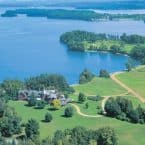
The best run here is to follow the course of the Green Mountain Marathon, following West Shore Rd. along the western shore of Lake Champlain for up to 11 miles. Great water and mountain views, rolling terrain, and part gravel. For a 5-mile out and back, turn around at Snow Farm Vineyard and Winery, and for a 9-mile out and back, turn around at Health Hero Farm. The start point is at Folsom School parking lot, near the house where Clarence H. Demar, 7 time Boston Marathon Winner, once lived. MARATHON COURSE MAP
Sand Bar State Park to Apple Island Resort. A short, gorgeous run on a causeway over Lake Champlain. Great lake views as you cross over to South Hero. It’s on Rt. 2, but good shoulder. 3.2 miles out and back. ROUTE MAP
North Hero
The best bets for running on North Hero are to choose a section of Rt. 2 with good lake views. It’s the main road, and there is traffic, but there’s a decent shoulder. Some good sections:
- North Hero Three Bays Route. From GR supporter Kassie Helm. A nearly 11-mile out and back route covering Carry Bay, City Bay, and Pelots Bay. Fantastic views. Starting along the north section of Rt. 2 and winding across the breadth of the island to the west side and up to the northern tip with a lovely yacht club. ROUTE MAP
Shorter Version: Rather than loop around Pelots Bay, run from Carry Bay along Rt. 2 to City Bay, but before approaching the town of North Hero, veer west on Savage Point Road, and follow that west, through farmland and along quiet and calm but substantive enough to run dirt road up to the east side of Pelots Bay. Turn back and retrace steps. ~6 miles (5 miles if you stop at City Bay).
- North Hero House Inn to Vermont Country Meats. This nearly 4-mile stretch of Rt. 2. is mostly along the water, with a couple of more interior stretches. Decent shoulder. Pretty running, and flat! ROUTE MAP
- North Hero State Park. Pleasant 3-4 miles of running on the park’s roads and paths, with farm and water views. To extend, take Lakeview Dr. just south of the park to North End Dr. Pretty farms!
- North Hero 10-Mile Loop (from Kassie Helm): For a cool 10-miler, the loop of North Hero along the main roads in an approximate perpendicular rectangle. Route 2 is the perimeter along the eastern side, down to South End Road, which comes just before the bridge to Grand Isle. Then turn west along South End Road until you reach West Shore Road, follow that up to Station Road which veers through lovely farmland and brings you back to Rt. 2. ROUTE MAP
Shorter Loop. cut off 2.5 miles or so by turning west at Sunset View Road, which cuts the rectangle in about half.
South Alburgh and Isle La Motte
- West side of North Hero & South Alburgh. Nice stretch of Rt. 2 from Holiday Harbor Inn on the west side of North Hero, over the causeway to South Alburgh, and then along Poor Farm Rd. in South Alburg to Alburgh Dunes State Park. A nice 10k out and back! Additional running in the park.
- Alburgh to Isle La Motte. Lovely waterfront running on Rt. 129 along the western shore of South Alburgh and over the causeway to Isle La Motte. This stretch is ~2 miles. Then there’s 1.5 interior miles crossing to the west shore of Isle La Motte, to a lovely section on W Shore Rd. along the west side of Isle La Motte. Great water views in the 3.5 mile stretch from Saint Anne’s Shrine to Fiske Quarry Preserve. ROUTE MAP
- Isle La Motte Loop. For a cool 10-miler, do the loop of Isle La Motte! From Saint Anne’s Shrine (seasonal outdoor church!), follow W Shore Rd for 4 miles to Historic Fiske Farm. Nice lake views! Then head east for 1 mile, turning north on Main St./Rt. 129, passing the Old School House and numerous farms, to complete the loop. ROUTE MAP
- South Hero Route: Exit 17 off I-89.

Comment on this Route/Share a Photo!
Share your feedback on this route and see that of other Great Runs users. Click on the image icon to upload a photo. And please let us know if there are notes or changes we should incorporate!