Features:
Categories:
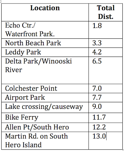
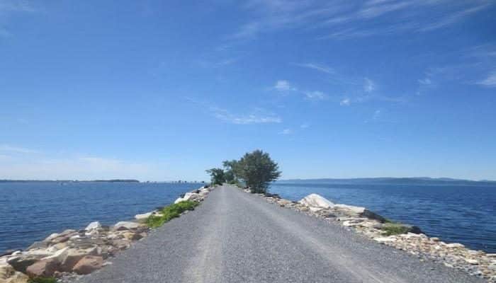
The Island Line Trail is one of New England’s most visited and spectacular rail-trails, and the signature running spot for Burlington. Also called the Burlington Greenway, this relatively flat, mainly paved trail borders the waterfront in downtown Burlington and strings together several shoreline parks in a linear path to offer spectacular views of Lake Champlain and New York’s Adirondack Mountains. The full trail is 13 miles, including a spectacular marble causeway over Lake Champlain at the northern end, connected to South Hero island via a bike ferry, which runs seasonally.
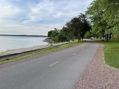
The southern terminus is at Oakledge Park on Flynn Street in southern Burlington, which offers plenty of parking and amenities. From there, the route travels north along the waterfront, passing through downtown Burlington, to North Beach, which is the 3.3 mile marker and offers remarkable lakeside views. Continuing north, the path is mainly wooded, with occasional views & observation points.
The Winooski River Bridge is just a few miles north and is the crucial link that unites the Island Line Trail and the Colchester Causeway. The 2.5-mile causeway is just beyond Airport Park. Running along the crushed stone surface of the causeway gives a sense of skimming the water’s surface. It ends abruptly where a seasonal bike ferry run by Local Motion connects 200 feet across “the Cut” to South Hero, where there’s an additional ~1 mile of trail.
Prettiest Sections: The ~3 miles between Oakledge Park & Downtown Burlington; the area around Winooski Bridge; and the Causeway.
Add-Ons: Once on South Hero, lovely running on Sunset Beach Rd. & W Shore Rd.
- Burlington section: 3.3 miles one-way; Entire trail: 13 miles (21 km)) one-way
- South End: Oakledge Park. Downtown access off King St. or College St.
- Numerous access points

Comment on this Route/Share a Photo!
Share your feedback on this route and see that of other Great Runs users. Click on the image icon to upload a photo. And please let us know if there are notes or changes we should incorporate!