Features:
Categories:
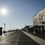
Bike paths dot the Jersey Shore, providing a great running alternative to the shore roads, beaches, and boardwalks. Here, we’ve put together a list of our favorite bike path segments for running, with an orientation to central location and pretty areas/good views. Note: Boardwalks are included in a separate post.
Sandy Hook: This is one of our favorite bike paths on the shore, and only a 35-minute ferry ride from Manhattan! Six miles out and back on a bike path, with great water views much of the way. Great views of the New York City skyline from Fort Hancock. Path Map & Info.
Henry Hudson Trail: Best shore section is the first 2 miles heading west from Popamora Point in Highlands to the Atlantic Highlands Ferry Terminal. Named after the 16th century explorer, the wide, paved, fairly flat trail follows on old railroad line for 24 miles from Highlands to Freehold, with a couple of breaks. It’s mainly tree-lined and interior. Trail information and Map. Route Map: North Section. Route Map: South Section.
Edgar Felix Bike Path: Paved path that runs 5 miles from Manasquan High School to Allaire State Park. Quiet and interior, through woods and passing playgrounds, farms, and a historic village. MAP
Barnegat Branch Rail Trail: 10 mile interior trail, best section is along forked river. MAP
Ocean City Bike Path: 5+mile trail includes a jaunt over the bridges of the Rainbow Channel to Somers Point with great views of the islanD-speckled coast. MAP
Wildwoods: A bike path runs the entire 5-mile length of the island. It is a dedicated bike path for 1 mile starting from Rambler Road in Wildwood Crest, then on the Boardwalk for about 2 miles, then paralleling JFK Street. There’s also a bike lane along Surf Ave. from 26th St. to 1st St. in North Wildwood. MAP
Cape May: Middle Township Bike Path begins near Cape May Courthouse and continues south for about 6 miles towards Rio Grande. The Cold Spring Bike Path is a 2.75 mile paved route which spans from Seashore Road in Erma to Sandman Boulevard in Cape May. A favorite day trip for visiting runners is to run to the Cape May Winery.
Pleasantville to Somers Point Bike Path: This 8-mile paved trail ties together some of the Shore’s key communities, including Pleasantville, Northfield, Linwood, and Somers Point. While most of the path is inland, it provides an important link to the waterfront for many of these residential areas. ROUTE MAP.
Island Beach State Park. A bike path runs along Shore Rd. Not very scenic as there aren’t water views.


Comment on this Route/Share a Photo!
Share your feedback on this route and see that of other Great Runs users. Click on the image icon to upload a photo. And please let us know if there are notes or changes we should incorporate!