Features:
Categories:
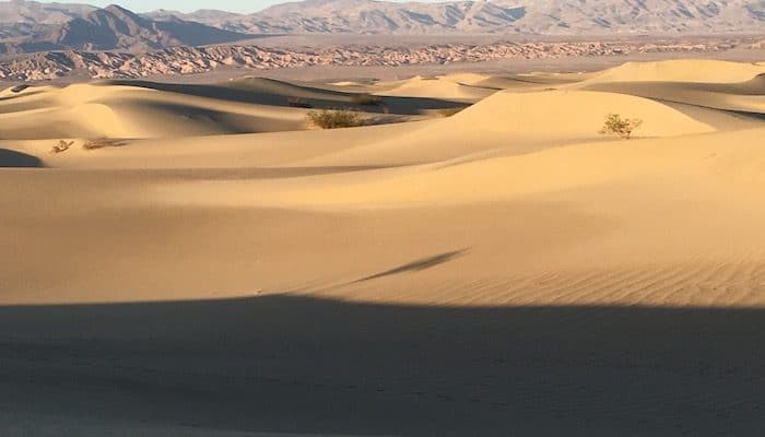
This park can be forbidding — hikes can be steep and narrow, and due to the open, desert-like terrain, many of the trails are not marked and one can get turned around. Cellphone coverage and GPS do not work well in the park. Finally, there is the weather. This is one of the hottest, driest places on earth, in summer. Temps in the valley areas often reach 120F (45C) or greater. Even at night it can be 100F. From November to May, the weather is more run-friendly, although nights and mornings can be cool. At altitude in winter, there can be snow and challenging terrain.
Given the extreme conditions and terrain, Death Valley is naturally home to several marathons and road races, including the Death Valley Marathon, run in February.
For the casual runner visiting the park, we have a few recommended spots. There are also some great opportunities for trail running. Most of the main places for running in Death Valley National Park are along the park roads. These roads can get busy with traffic, especially in season (November-May). You should be OK if you run against traffic, and during daylight hours. Note that very few roads have shoulders and where there is a shoulder the surface is gravel and can be soft and challenging for running.
Badwater Road
This is the most popular of the main roads in Death Valley National Park for running. It is less trafficked than Rt. 190, the main park road. It’s also fairly flat. There are great views of the Black and Paramint Mountains and the canyons/badlands to the east. A good section for running, close to many of the main sites, is the 11-mile stretch between Furnace Creek and Badwater Basin. Note that the road is not wide and the shoulder is sloped, so for the most part you need to stay in the road. Cars drive fast and there can be a lot of cars in season. Please use caution.
Furnace Creek Area
For those staying near Furnace Creek, either at the Inn, Ranch, or from the Visitor Center, there are a few places to run off the main park road. There are roads around the Sunset and Texas Spring campgrounds, which can give you a couple of miles of running. Also, behind the Visitor Center, is quiet, shaded Airport road, which runs out 0.75 miles to the airfield and a wildlife viewing platform. There is a sidewalk from the Visitor Center to Mustard Canyon (1.4 miles, 1k).
Artists Drive
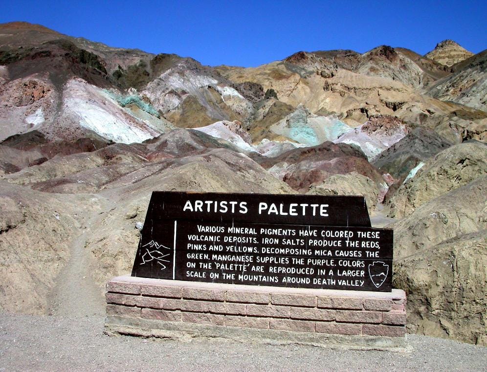
This is a challenging 9-mile loop road, popular with runners and cyclists, as it is paved and off the main road. Traffic flows one-way. To do a full loop requires an additional 3 miles on Badwater Rd. Given the length and challenge, we recommend doing a section of Artists Drive, near the Palette. Especially nice in the late afternoon light, with views to multi-hued volcanic and sedimentary hills. The road gets quite close to the hills at Artists Palette, where there are also restrooms. Note: Artists Drive is quite narrow with no shoulder. This is a hilly, challenging run with 1,700 foot elevation gain if you do all 12 miles.
Twenty Mule Team Canyon
Not far from Furnace Creek and Zabriski Point, this is another good opportunity to run off the main road. It’s a 2.7 mile one-way loop along an unpaved road, winding through spectacular badlands.
Golden Canyon/Gower Gulch Loop Trail
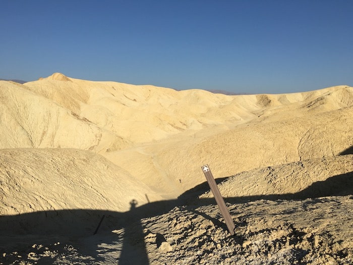
This is a trail run but fairly run-able for the novice to intermediate trail runner. I am also high on this run because it is one of the few marked trails in Death Valley NP. From the parking lot, one great option is the 1.5 miles one way to Red Cathedral. This is quite run-able, sort of like a rough dirt road. Hit it early in the morning or in the late afternoon/evening for the best light.
A more ambitious option is the 10k Golden Canyon Gower Gulch Loop. The gulch section is an empty riverbed, through badlands and canyon narrows. There are a couple of rocky/steep sections where you should walk/hike, but most of this trail is run-able This is one of the more spectacular trail runs you’ll ever do. Start at Zabriskie Point. The footing is fairly decent for most of the route. There’s lots of elevation: 962 feet over 6.1 miles – first part down, second part up. Thanks to Aurélie Vilmer, who suggested this route. ROUTE MAP
Badwater Flats
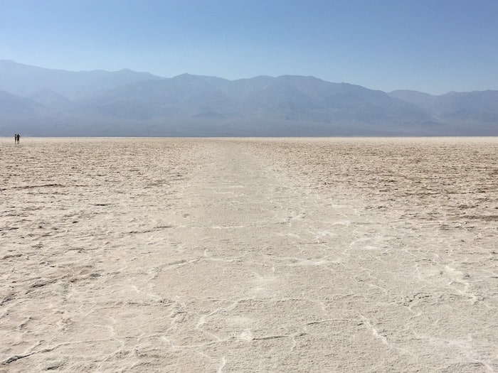
One of the unique places to run in the world. Want to run at 243 feet below sea level, the lowest point in the Western Hemisphere? You can do it at Badwater Flats. Just off Badwater Rd., 17 miles south of Furnace Creek, is a parking lot and interpretive signs describing this unique phenomenon. It is possible to walk/run on the flats. The trail is flat (!) and wide, with no vehicles. The first ½ mile or so is a very smooth, hard pack surface, perfect for running. After ½ mile, the surface becomes rougher and bumpier, and it can be challenging for running (you don’t want to fall here — literally, it would be salt rubbing in your wounds). At this point, walking is easier than running. One can walk/run for 5 miles across the flats. And while this might be the lowest point in the Western Hemisphere, you can also run at the lowest point on Earth, on a bike path along the Dead Sea in Israel.
Note: Do not do this in really hot weather — as this is about the hottest spot in Death Valley. Also, be careful if it is raining, the area could be filled with water. Also, the surface condition can change depending on recent weather.
Ash Meadows Wildlife Refuge
Located 30 minutes from the park, but across from the Longstreet Inn and Casino (a popular motel with visitors to the NP). The largest remaining oasis in the Mojave Desert with at least 26 plant and animal species found nowhere else on the planet. There are several boardwalks and paths which make for great running. Highlights are Crystal Spring Boardwalk, leading to a brilliant blue spring flowing at 2,800 gallons per minute; the stone cabin of Jack Longstreet, and Point of Rocks, and Kings Spring, home to a rare species of pupfish.
Ghost Town Run
6.3 miles (10k) out and back. 418 foot gain. Start: Off Rt. 374. ROUTE MAP
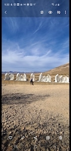
Just east of Death Valley NP, but actually in Nevada, here’s an opportunity to run to a bona fide ghost town — actually used in movie sets! Near Beatty, NV just off Rt. 374, a gravel road leads for 2.5 miles to Rhyolite. Continue for another 0.5 miles to the Goldwell Open Air Museum, passing Tom Kelly’s Bottle House. It’s not too hilly and the footing is good. Note – very exposed, use caution in heat. Thanks to Aurélie Vilmer, who suggested this route.

Comment on this Route/Share a Photo!
Share your feedback on this route and see that of other Great Runs users. Click on the image icon to upload a photo. And please let us know if there are notes or changes we should incorporate!