Categories:
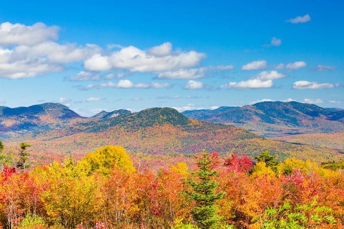
In between summer swimming and winter skiing, tourists descend on New Hampshire for a dose of fall foliage — from the crisp air of the White Mountains to the salt spray of the eastern seaboard. It’s a season usually associated with hikers and car-bound “leaf peepers,” but the chilled temperatures and colorful vistas of New Hampshire in autumn are a runner’s fantasy.
New Hampshire is a small state, but long, so temperature, elevation, and peak foliage can vary dramatically from the seaside towns to the hilly villages, to the mountainsides. Though it depends on weather conditions, New Hampshire foliage generally peaks from late September to mid-October, and expires sooner the further north you travel.
No matter where you travel in New Hampshire, we’ve got a run for you! These runs are enjoyable anytime of the year, but this list is specially curated to include scenic routes for optimal foliage viewing. So lace up, hit the pavement or the trails, and prepare to be wowed by a peek at New Hampshire in it’s fall-finest.
White Mountains Region
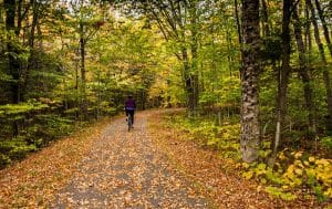 Franconia Recreation Trail: With nearly nine miles of paved rail trail in one of the most scenic notches of the White Mountains, the Franconia Notch State Park Recreation Path is hard to beat in terms of views and accessibility. The path travels for nearly 9 miles from Flume Gorge in the south to Skookumchuck & Rt. US 3 in the north. There is an 800 foot elevation gain from south to north. The northern terminus is about a 1 hour drive from North Conway, a popular destination for visitors to the Whites. Ambitious runners can take on the entire length of the path, but for a shorter jog, we recommend the southern end of the trail. This slightly uphill route will take you from The Flume parking lot, over Whitehorse Bridge, and through the Basin viewing area where you can explore the geological formations of the Pemigewasset River. You’ll pass Echo Lake, and Cannon Mountain. One option is to run one-way and use the Cannon Mountain Shuttle, which runs seasonally, for the return. Whichever length you choose, you’ll be rewarded with colorful mountainside views.
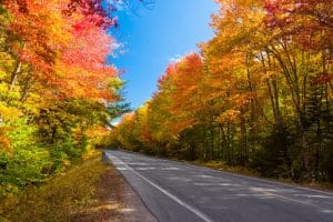 Kancamagus Highway: Although popular among sightseeing motorists and hardcore bicyclists, “the Kanc” has a wide enough shoulder for runners who want to take in the views on this scenic stretch of highway. This section of route 112 spans 32 miles between Lincoln and Conway, and boasts many trailheads, but the most spectacular views on the road itself are around the CL Graham/Wangan Grounds Scenic Overlook, the highest point where two rivers spill down from Mount Kancamagus, and you can see the whole valley painted with color. Running along the Kancamagus is a treat…and a challenge. You can run along any spot of the highway, but we’ve mapped a route that starts from the CL Graham Picnic Area just west of the pass and the Pemigewasset Overlook, for a total distance of 5.6 miles with an 850 foot elevation gain. The shoulder is adequate, but use caution. If you prefer a one-way trip, the Lakes Region Airport Shuttle does offer a shuttle on a charter basis.
Note: Use caution. Many drivers have their eyes on the stunning overlooks and not the road. Run opposite traffic. Also, a recreation pass (which can be purchased at ranger stations) is needed to park in areas along the highway.
Sugar Hill: With a name like Sugar Hill, how could this New Hampshire town be anything less than quaint? Although it’s technically the newest town in the state, incorporated in 1962, this tiny, tight-knit community is possessed of a rustic charm, from its white steepled meetinghouse to its grand central inn. And with sweeping views of Mount Lafayette and forests of the White Mountains, it’s a prime place to peep some foliage away from the crowds. The town does get its fair share of tourists on Route 117 during foliage season, but the views along this stretch are worth it. You can round out the route on the stonewall-lined backroads around the Sugar Hill Town Forest. The loop from Grandview Road to Center District, Jesseman, and Blake Roads, just north of the highway, is a perfect spot for a secluded foliage run.
Route Map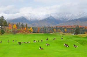 Mount Washington Resort/Bretton Woods: Running up the long driveway of the The Mount Washington Resort, with its famed red roof, wrap around porch, and views of Mount Washington in the background, is a highlight of the White Mountains. One of the last Grand Dame hotels still standing, the hotel (which hosted the Bretton Woods Conference in 1944) is part of the larger Bretton Woods resort, which features a ski area across the street, a golf course, and extensive trails for nordic skiing in winter and running/cycling in summer. Come fall, you can reward yourself with a chairlift ride to the summit, and watch the glory of autumn unfold beneath you. Running the trails and extensive grounds of the Mount Washington Resort is a special treat. Start from Rt. 302 at the entrance to the hotel or near the AMC Highland Center, about 3.5 miles east of the resort (which also has killer views). Note: there might be someone at the gate near the hotel entrance, and there might be a charge for use of the nordic/mountain bike trails.
For more running in the White Mountains Region, check out our guide to North Conway.
Lakes Region
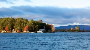 Lake Winnipesaukee: This massive lake, situated in the center of New Hampshire, is a favorite of foliage viewers for its expansive water views, revealing color changes on the chain of forested islands which dot the lakes region. Even on a map, it’s hard to comprehend just how huge the 71 square mile lake is, but it offers up a variety of quiet back roads from which to enjoy the colorful lakeside scenery. Lots of runners favor 2.5 mile long Sewall Road in Wolfeboro (one of the year round hubs for tourism in the Lakes Region.) As traffic is light in fall, the shoulder is adequate, and you’ll get amazing views of the village, beaches, boats bobbing in Wolfeboro Harbor, and some of the grand homes in the neighborhoods bordering the lake. A nice 4-mile nice incorporates Sewall Rd., Forest St., and N.Main St. (Rt 109). ROUTE MAP
Another good option is the Cotton Valley Rail Trail, which cuts through Wolfeboro on the Eastern side of the lake. The trail runs for 11 miles between Wolfeboro and Rt. 16 in Wakefield, but the most ‘runnable’ part is 6.2 miles from downtown Wolfeboro to East Wolfeboro. A good 4 mile out and back is from Wolfeboro to Albee Beach. The highlight is the two long causeways along Lake Wentworth and Crescent Lake.
For runners on the other side of the lake, the expansive views along the aptly named Scenic Roads, (two of them) near Weirs Beach and Glendale, make for rewarding routes.
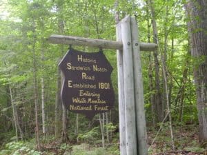 Squam Lake/Waterville Valley Area: Sandwich Notch Road: Where Squam Lake rises up to meet the Waterville Valley, this 11 mile dirt road runs from Route 113 in the center of Sandwich to Route 49 which continues up to the ski resort. Though you won’t see great lake vistas here, the “Notch Road” is a nearly traffic-less hill with a soft surface. And this route is about as rural as they come — in winter, it’s closed to cars except for a series of dog-sled races. If you’re feeling extra-energetic, you can branch off and enjoy one of the many single-track trails that link to the Notch Road. To get there, follow Grove Street north out of Sandwich until it turns into Diamond Ledge Road. Park your car on Grove, and run up Diamond Ledge about two miles. Just after the top of the hill, Diamond Ledge becomes Sandwich Notch Road. If you run all the way to the end of Sandwich Notch, you’ll gain 900 feet of elevation in a little over five miles!
Merrimack Region
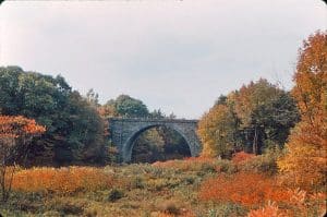
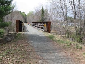 Northern Rail Trail: The industrial Merrimack River region is oft overlooked when it comes to fall foliage, but the Northern Rail Trail, which runs from Lebanon to Boscawen, is a fantastic, scenic run. At 58 miles, the NRT is the longest rail trail in New Hampshire, so you may want to choose just one section for an out and back. The trail runs through the towns of Danbury, Wilmot, Andover, Franklin, and Boscawen, so you have options upon options. Just beware that not all sections have been primed for running — some are still covered with ballast formerly used to hold railroad ties in place. Two good starting options are the Country Store in Danbury and the Highland Lake Inn in Boscawen, which serve as welcome centers to the trail and are complete with amenities. As far as scenery goes, the section along the Mascoma River between Lebanon and Enfield winds through a lovely glacial valley before meeting up with the shores of secluded Lake Mascoma. The views of the Merrimack River on the Boscawen end of the trail are also remarkable, and easy to access. To determine which rivers, lakes, and trestle bridges to include in your foliage view, check out the maps from the Friends of the Northern Rail Trail.
Dartmouth / Lake Sunapee Region
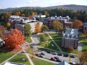 Dartmouth College: Fall symbolizes back to school time, so why not get your foliage fix with a run around one of New England’s most scenic college campuses? Dartmouth College, on the Connecticut River in Hanover, is known for its stately brick buildings and large, active outing club — so you know it’s supremely runnable. Enjoy a long jaunt along the banks of the river on River Road, or explore the landscaping of campus to find a flourish of fall leaves set against a classic New England backdrop. The Lyme Road and Rip Road, which run alongside campus, are a great addition to any run and serve as easements to some beautiful nature preserves and recreation areas. For more ideas on running routes in the Hanover area, check out the interactive map from Dartmouth’s Cross Country Team.
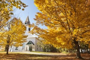
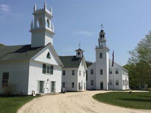 Washington: The whitewashed church and town hall of Washington center make a lovely foreground to the brightly colored foliage that lines the New Hampshire hills come autumn. Although Washington shares its name with New Hampshire’s highest peak, this small New England town is just South of Mount Sunapee. Route 31, which runs through the town center, is rather narrow, but the gorgeous side streets encircling the region’s lakes make for incredible runs. Try the Halfmoon Pond Road (6+ miles to the Washington Town Forest) or the Clemac Trail Road, which runs for ~3 miles along Butterfield Pond in Pillsbury State Park. With foliage lined hills reflecting on boggy ponds, you can’t beat these views.
Seacoast Region
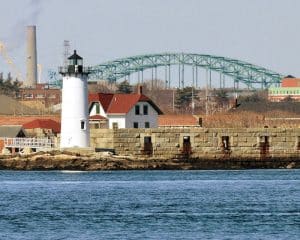 Portsmouth: The New Hampshire seacoast is short, but gorgeous, and it’s crown jewel is Portsmouth, a hip and historic port city on the Picataqua River. Especially if you’re coming from the South, Portsmouth is an easy detour off Route 95 for a scenic salt air run. Your route may take you anywhere on the city sidewalks, but make sure you don’t miss the waterfront at Prescott Park, where you can watch the color change and the boats go by all at once. The team at Runner’s Alley shoe store also recommends a 7.5 loop starting from their store and looping out the the island of New Castle. The route runs over beaches, bridges, and a lovely wooded area before returning to the center of town. Note: Portsmouth is also home to several popular brewpubs, so foodies and beer aficionados might want to make a night or a weekend out of it!
Monadnock Region
 Keene Village and Trails: Visitors to the Monadnock Region know that the hills of southwest New Hampshire can be just as beautiful as the White Mountains — just as charming and just as rugged. Hardcore trail runners can enjoy the views from the bald summit of Mount Monadnock, but the villages around the Monadnock foothills are equally enjoyable for views of warmly colored leaves. From Peterborough to Dublin, the small rural towns near Monadnock have great rolling roads for a long scenic run, but the village of Keene is our top pick for a fall run. This cool college town is a hub for art and restaurants, and it even holds a pumpkin festival in late October — prime time for leaves in southern New Hampshire. Run through town, find a nearby trail, or hop on one of two railway paths to enjoy towering views of Monadnock itself. The Cheshire Rail Trail runs for 1.2 along the Massachusetts border from Keene, and runs into the Ashuelot Rail Trail, which stretches 1.5 miles north to south along the river. The Asheulot River Park, near where they intersect, is particularly nice.
Manchester/Concord Region
Manchester: Piscataquog Trail/Goffstown Rail Trail
Concord: West End Farm Trail
__________
Feeling Competitive? Find a local 5K or try one of these fall races:
Smuttynose Rockfest, Hampton hamptonrockfest.com
Applefest Half Marathon, Hollis applefesthalfmarathon.com
New Hampshire Marathon, Bristol nhmarathon.com
Bretton Woods Fell Race, Bretton Woods acidoticracing.com/bretton-woods-fell-race

Comment on this Route/Share a Photo!
Share your feedback on this route and see that of other Great Runs users. Click on the image icon to upload a photo. And please let us know if there are notes or changes we should incorporate!