Wikimedia
Features:
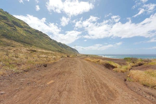
A wonderful and accessible trail run to Ka‘ena Point in the northwestern part of Oahu. The trail runs along a former rail bed and dirt road, so it is fairly wide and not technical. Wonderful water and open views the whole way. There are views of boulder beaches, tidal pools, cliffs, coastal plain, and sand dunes.
The entire trail is about 4.5 miles, but there are two sections. On the Mokule‘ia side, the trail begins at the end of Farrington Hwy. (Rt. 93) at Keawaula Beach. It is 2 miles to Ka‘ena Point. On the Wai‘anae side, take the trailhead at the end of Farrington Hwy. (Rt. 930), for 2.5 miles to Ka‘ena Point.
For a longer run, it is possible to run on the road, which is scenic but there isn’t much of a shoulder, so please use caution.
Trail InformationEssentials
- Entire trail is 4.5 miles; Mokule‘ia side is 2 miles to Ka‘ena Point and on the Wai‘anae side it is 2.5 miles
- Entire trail: 193 feet
- Mokule‘ia side: Trailhead at the end of Farrington Hwy. (Rt. 93) at Keawaula Beach. Wai‘anae side: Trailhead at the end of Farrington Hwy. (Rt. 930)


Comment on this Route/Share a Photo!
Share your feedback on this route and see that of other Great Runs users. Click on the image icon to upload a photo. And please let us know if there are notes or changes we should incorporate!