
Google Street View
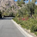
This 4-mile loop takes you through the city’s older, picturesque, palm-lined residential streets. Our route is derived from the City of Palm Springs bike map. There are good sidewalks. It runs off S. Palm Canyon Dr., near the Moorten Botanical Garden. Run east along Mesquite Dr., for 1 mile to S. Sunrise Way, then for another mile to S. Laverne Way. Then head north for the back half of the loop, along S. Camino Real, and then S. Calle Palo Fierro.
City of Palm Springs Bike & Trail MapEssentials
- 4 mile loop
- 100 feet
- S. Palm Canyon Dr. & E. Mesquite Rd.

Comment on this Route/Share a Photo!
Share your feedback on this route and see that of other Great Runs users. Click on the image icon to upload a photo. And please let us know if there are notes or changes we should incorporate!