Categories:
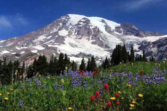
Note that Mount Rainier receives copious amounts of rain and snow. Running is a challenge in the winter. Many roads in the park don’t open until late May. PRO TIP: Famous for its wildflowers in summer.
Roads/Bicycling Trails Good for Running
Westside Road
Westside Road is a gravel road suitable for running and bicycling that runs off the main park road at the western side of the park up to Mt. Wow. The road is car-free after the first 3 miles, which is the least hilly part of the run. It gets a lot steeper after that. It’s 7 miles to Marine Memorial Airplane Crash/Gobblers Knob Trail. There are challenging climbs and many spectacular views along this 9¼ mile stretch to Klapatche Point.

Carbon River Trail
This former road in the Carbon River Valley is a good rainforest trail for running and biking. It’s about 5 miles from the Carbon River Entrance, east to Ipsut Creek campground.
NF #52
Forest road, closed in winters, that is relatively free of cars. Run anywhere along the 25 miles from Ashford to Packwood.
One of the better opportunities for a flatt-ish road run in the park. Fairly wooded, run along the White River. It’s 5.5 miles along White River Rd., then Sunrise Park Rd., from the White River Campground to Rt. 410. The route starts 10 miles from the Sunrise Visitor Center. For a real adventure, you can run 10 miles downhill, losing 2,000 feet of elevation, along Sunrise Park Rd. from the Sunrise Visitor Center.
Hiking Trails Good for Running
This trail parallels Rt. 123, from Grove of the Patriarchs to Chinook Pass, about 9 miles, with 2,700 feet of elevation gain. One of the more accessible, long runs in the park. The first 3-4 miles is less steep. Towering, thousand-year-old Douglas fir and western red cedar trees. A gentler option is the 1.3 mile Grove of the Patriarchs Trail loop, only 100 foot elevation gain on an easy to follow boardwalk.
Pacific Crest Trail/Naches Peak Loop Trail. 3.5 mile loop
 This is mainly a hiking trail, but the section near Tipsoo Lake, at the eastern end of the Park, is wider, flatter, and suitable for running. A good loop, also popular with hikers/walkers, is the Naches Peak Loop Trail. Park at Tipsoo Lake, .5 mile west of Chinook Pass on SR 410. For a clockwise hike of the Naches Peak Loop Trail, follow the trail from the picnic area to Chinook Pass and the Pacific Crest Trail. Start out along the Pacific Crest Trail at Chinook Pass and head south, traversing the east side of Naches Peak 1.6 miles until intersecting the Naches Loop Trail. To continue the loop and return to Tipsoo Lake in 1.4 miles, follow the Naches Loop Trail along the west side of Naches Peak. 500 feet of elevation gain.
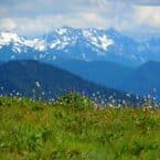
Sourdough Ridge Trail. 4 miles one-way. Start: Near Sunrise Visitor Ctr.
 A good trail for running near the Sunrise Visitor Center. Beautiful subalpine meadows and a relatively gentle climb to the ridge, with great views of Mount Rainier, with Mount Baker, Glacier Peak, and Mount Adams in the distance. The trail is 4 miles, with 260 feet of elevation gain — but note it’s at 6,500 feet. From the Sunrise Visitor Center, walk 0.5 miles up to the trail. It’s 1.5 miles west to Frozen Lake, and 2.5 east to Sunrise Point. It is 1.9 miles from the Visitor Center to Dege Peak, with 500 feet of elevation gain– most of it at the beginning and end of the trail.
Wonderland Trail. Between Longmire & Cougar Rock, ~2 mile section.
The 93-mile Wonderland Trail circles Mt. Rainier. A decent and accessible spot to run is the nearly 2 miles between Longmire and the Cougar Rock campground, about 500 feet in elevation gain.

Comment on this Route/Share a Photo!
Share your feedback on this route and see that of other Great Runs users. Click on the image icon to upload a photo. And please let us know if there are notes or changes we should incorporate!