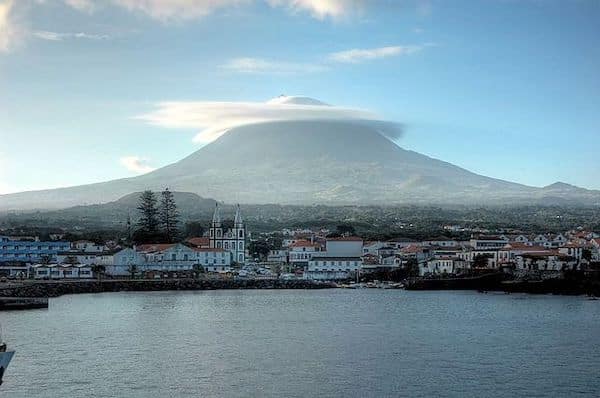
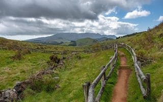
Pico is the second largest island of the Azores, at 42 km of long and 15 km wide. A dominant feature is the majestic 2,350m Volcano of Pico. It’s a spectacular landscape, with farms, rainforest, and fields of black lava spilling down to the beach. This part of our guide to running on Pico is focused on scenic, safe waterfront roads and paths along the waterfront. Outside some of the coastal roads, the island’s terrain can be very hilly. Note that most of these roads don’t have a shoulder or sidewalk, but they’re not heavily trafficked. PRO TIP: We highly Atipico for a guided hike up 2,351m Mount Pico. We had a great experience with our guide, Monica.
Road/Cycle Path Between Madalena and Arcos. This scenic and wonderful run is on one of the longest multi-use paths in the Azores. A cycle path was installed as part of a widening project of the coastal road that runs northeast from Madalena toward Arcos. The path is alongside the main road, but is wide and paved, with a smooth surface. There are views of the rocky coast, Faial and São Jorge islands in the distance, lava vineyards, and Pico’s verdant, hilly landscape to the interior. The distance is up to 13.2 km. Gentle rolling hills. Close to Madalena, there’s a road right along the water below the main road for ~1 km. INFORMATION. ROUTE MAP
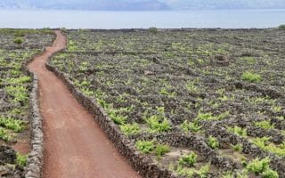
South of Madalena. This is our favorite run in the Madalena area. A lovely, flat path runs south of Madalena for 3.6 km, with great views of back lava fields and the sea. Part paved (concrete & cobblestone), part dirt. There are some sections of the road that are part of the Vinhas da Criação Velha trail, now a UNESCO site highlighting the wine growing tradition on Pico. ROUTE MAP
San Antonio Area. Just east of Arcos, enjoy 4.5 km of scenic waterfront running east of San Antonio on Av do Ma. Quiet roads, nice water views! There are some rolling hills to contend with. ROUTE MAP
São Roque Area. Nearly 2 km of flat waterfront running along Av. do Mar. Nice water views. and a great swimming spot for a post-run dip or shower!
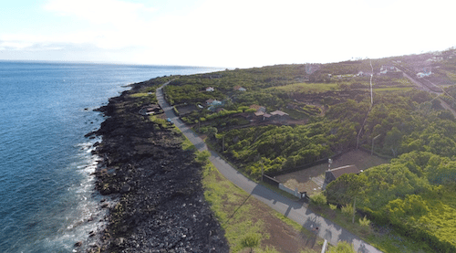
Prainha Area. In the Prainha area, there are 7.5 km of small, quiet roads that are either along the water or just above it. Starting just west of Prainga at the Adega Açoriana restaurant, head east as far as Terra Alta. Most of the road has water views. It is rolling hills, with a couple of longer, steeper sections. Note: No shoulder, but not heavily trafficked. ROUTE MAP
S Mateus area. Google Street View
São Mateus Area. On the more rugged & remote southern part of Pico, a quiet coastal road extends east of São Mateus for nearly 4 km. Views of stark lava fields and the North Atlantic. ROUTE MAP
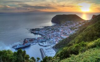
Lajes do Pico. East of São Mateus, one can stitch together 2-3 km of waterfront running on the coastal road and the pier. For the more ambitious, a small road continues east toward Santa Barbara, past the Jardim Penedo Negro, climbing above the water. There are fantastic views of the water, on one side, and hillside gardens/vineyards on the other. It’s a ~140m climb over ~3 km. ROUTE MAP
Pico is the second largest island of the Azores, at 42 km of long and 15 km wide. A dominant feature is the majestic 2,350m Volcano of Pico. It’s a spectacular landscape, with farms, rainforest, and fields of black lava spilling down to the beach. This part of our guide to running on Pico is focused on scenic, safe waterfront roads and paths along the waterfront. Outside some of the coastal roads, the island’s terrain can be very hilly. Note that most of these roads don’t have a shoulder or sidewalk, but they’re not heavily trafficked. PRO TIP: We highly Atipico for a guided hike up 2,351m Mount Pico. We had a great experience with our guide, Monica.
Road/Cycle Path Between Madalena and Arcos. This scenic and wonderful run is on one of the longest multi-use paths in the Azores. A cycle path was installed as part of a widening project of the coastal road that runs northeast from Madalena toward Arcos. The path is alongside the main road, but is wide and paved, with a smooth surface. There are views of the rocky coast, Faial and São Jorge islands in the distance, lava vineyards, and Pico’s verdant, hilly landscape to the interior. The distance is up to 13.2 km. Gentle rolling hills. Close to Madalena, there’s a road right along the water below the main road for ~1 km. INFORMATION. ROUTE MAP
South of Madalena. This is our favorite run in the Madalena area. A lovely, flat path runs south of Madalena for 3.6 km, with great views of back lava fields and the sea. Part paved (concrete & cobblestone), part dirt. There are some sections of the road that are part of the Vinhas da Criação Velha trail, now a UNESCO site highlighting the wine growing tradition on Pico. ROUTE MAP
San Antonio Area. Just east of Arcos, enjoy 4.5 km of scenic waterfront running east of San Antonio on Av do Ma. Quiet roads, nice water views! There are some rolling hills to contend with. ROUTE MAP
São Roque Area. Nearly 2 km of flat waterfront running along Av. do Mar. Nice water views. and a great swimming spot for a post-run dip or shower!
Prainha Area. In the Prainha area, there are 7.5 km of small, quiet roads that are either along the water or just above it. Starting just west of Prainga at the Adega Açoriana restaurant, head east as far as Terra Alta. Most of the road has water views. It is rolling hills, with a couple of longer, steeper sections. Note: No shoulder, but not heavily trafficked. ROUTE MAP
S Mateus area. Google Street View
São Mateus Area. On the more rugged & remote southern part of Pico, a quiet coastal road extends east of São Mateus for nearly 4 km. Views of stark lava fields and the North Atlantic. ROUTE MAP
Lajes do Pico. East of São Mateus, one can stitch together 2-3 km of waterfront running on the coastal road and the pier. For the more ambitious, a small road continues east toward Santa Barbara, past the Jardim Penedo Negro, climbing above the water. There are fantastic views of the water, on one side, and hillside gardens/vineyards on the other. It’s a ~140m climb over ~3 km. ROUTE MAP
A pleasant waterfront run in Ponta Delgada -- capital of the Azores and its largest city. It's one of the few opportunities on São Miguel for a flat, easy run along the water. 10k out and back, and great views!
Easy trail run along a path above the water on the northern coast of São Miguel, between Calhetas and São Vicente Ferreira. Fantastic views the whole way. Path is more of a wide dirt road. Up to 6.5 km one-way.
Easy and scenic 6 km loop on a path around this popular lake. Great views of the lake, surrounding mountains, and lovely trees and flowers. There are hot springs at the lake's southern end. Also possible to run from Furnas (hilly!).
We've scoped out the best options for safe and scenic waterfront running on the island of Terceira. Includes routes in Angra do Heroísmo, Negrito, the area around Fort of Greta, Biscoitos, and Praia da Vitória.
Terceira has a wonderful network of well-waymarked walking and hiking trails. Those that are classified as 'easy' good trail runs for the average runner. Those marked as 'medium' or 'difficult' are more challenging trail running.
Our recommendations for some of the walking/hiking trails on Pico that are an easy-to-moderate trail run. Lava fields, vineyards, coastal views. Vinhas da Criação Velha is a favorite. Also we point out some of the scenic, quiet interior roads.
We've scoped out some scenic, (relatively) flat waterfront routes on São Jorge island: Velas (including two running tracks!), Calheta, & Urzelina. Trail runners looking for scenery & hills will be in heaven!
A small, scenic, and hilly island! The best, easy waterfront run is in the city of Horta, location of the ferry terminal. Get the heart rate up by adding the road up Monte Guia!
Share your feedback on this route and see that of other Great Runs users. Click on the image icon to upload a photo. And please let us know if there are notes or changes we should incorporate!


Review or Comment on This Route/Share a Photo!
Share your feedback on this route and see that of other Great Runs users. Click on the image icon to upload a photo. And please let us know if there are notes or changes we should incorporate!