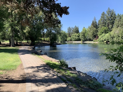
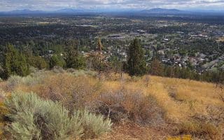
The Deschutes River Trail System is the crown jewel of the Bend Parks and Recreation Department’s Urban Trails System. The multi-use path is next to the beautiful Deschutes River, winding from mostly pine trees and hard-packed dirt through a couple of deciduous sections, around groves, meadows, and past a few class-four rapids. It’s rolling gradual headed out of Bend. Once fully developed, it will consist of 19 contiguous miles of trail alongside the river, but today there are 11 miles of completed sections, not all contiguous. The various sections of the trail are known as “reaches,” which are characterized by neighborhoods and surrounding landscapes. This is the Central section — see the Deschutes River Trail: River Run Reach for the outer sections.
Drake Park section. Author photo
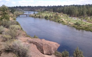
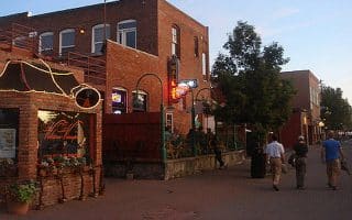
Central Section. The most central, park-like, and easy to follow section of the Deschutes River Trail is the 2.5 miles from Drake Park downtown, south to the end Farewell Bend Park. There are numerous pedestrian bridges crossing the river, but the path is most seamless on the east side. Just south of Drake Park, there’s a short on-road section along NW Riverfront St. Just south of there, in the Whitewater Park/Old Mill area, it’s fun to see the white water rafters, tubers, and surfers negotiate the rapids! In this area, there are paths on both sides, with Riverbend Park on the west side and Farewell Bend Park on the east side. There are multiple loop options, especially between Old Mill and Farewell Bend Park. We’ve mapped a 5-mile loop incorporating the pedestrian bridges.
South of Farewell Bend Park Add-On: From the end of Farewell Bend Park, a gravel path continues south for ~1.25 miles, making for a nice 2.5-mile add-on. Nice for running but a bit less developed.
Add-Ons: Wonderful neighborhood running just east of Drake Park, in the Drake Park and Old Bend Historic Districts, and further south in the Old Mill area.
The Deschutes River Trail System is the crown jewel of the Bend Parks and Recreation Department’s Urban Trails System. The multi-use path is next to the beautiful Deschutes River, winding from mostly pine trees and hard-packed dirt through a couple of deciduous sections, around groves, meadows, and past a few class-four rapids. It’s rolling gradual headed out of Bend. Once fully developed, it will consist of 19 contiguous miles of trail alongside the river, but today there are 11 miles of completed sections, not all contiguous. The various sections of the trail are known as “reaches,” which are characterized by neighborhoods and surrounding landscapes. This is the Central section — see the Deschutes River Trail: River Run Reach for the outer sections.
Drake Park section. Author photo
Central Section. The most central, park-like, and easy to follow section of the Deschutes River Trail is the 2.5 miles from Drake Park downtown, south to the end Farewell Bend Park. There are numerous pedestrian bridges crossing the river, but the path is most seamless on the east side. Just south of Drake Park, there’s a short on-road section along NW Riverfront St. Just south of there, in the Whitewater Park/Old Mill area, it’s fun to see the white water rafters, tubers, and surfers negotiate the rapids! In this area, there are paths on both sides, with Riverbend Park on the west side and Farewell Bend Park on the east side. There are multiple loop options, especially between Old Mill and Farewell Bend Park. We’ve mapped a 5-mile loop incorporating the pedestrian bridges.
South of Farewell Bend Park Add-On: From the end of Farewell Bend Park, a gravel path continues south for ~1.25 miles, making for a nice 2.5-mile add-on. Nice for running but a bit less developed.
Add-Ons: Wonderful neighborhood running just east of Drake Park, in the Drake Park and Old Bend Historic Districts, and further south in the Old Mill area.
Scroll Down For Route Maps
Essentials
2.5 miles between Drake Park and Farewell Bend Park. Extension south of Farewell Bend is 1.25 miles
103 feet
Downtown end: Drake Park. Or other spot on trail.
Parking: downtown. Also parking lots in the Old Mill shopping area, and at Riverbend Park
You won’t find many McMansions around Bend, but if you’d like to explore some of the nicer residential areas of the city on your run, there’s no better choice than Northwest Crossing (affectionately shortened to NWX) which was built on a Ponderosa Tree Farm.
At over 600 acres, Shevlin Park is Bend’s largest park — and it has a great 6 mile loop curling around the rim of Tumalo Creek canyon. The park is 3 miles from Bend. Tumalo Creek rambles through the park with several foot bridges.
The local runners at FootZone recommend heading out on Phil’s Trail, which is the common name for a network of several trails that span a total of about 40 miles between Skyliners Road and Route 372. Starts about 4 miles west of Bend.
Run to the top of an extinct volcano! The Larkspur Trail is the gem of Eastern Bend, and while it curls out into some urban streets, the iconic section is Pilot Butte Park, where the trail plateaus with a stunning view of Bend's high desert.
When it comes to running in Bend, the team at Footzone is the most trusted source for great route advice. In fact, they’ve mapped out a series of road runs between 3 and 10 miles in length to help you choose the best streets to sprint on.
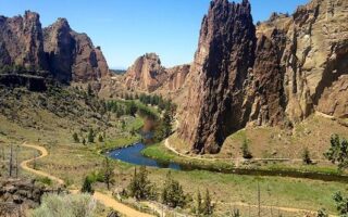
A worth-it destination run! Easy trail run on a canyon valley floor along a river with stunning views of towering rock spires. Located 1/2 hour north of Bend. More advanced trail running options as well. Also fun to watch the rock climbers!
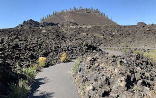
Run a paved path across a basalt lava flow! This is among the running highlights at the Lava Lands, only 15 minutes from Bend. Other great options include running the Lava Butte hill, a 5.3-mile paved multi-use path, and several trail running options.
Share your feedback on this route and see that of other Great Runs users. Click on the image icon to upload a photo. And please let us know if there are notes or changes we should incorporate!
Subscribe
0 Comments
Oldest
Newest
Inline Feedbacks
View all comments
Essentials
2.5 miles between Drake Park and Farewell Bend Park. Extension south of Farewell Bend is 1.25 miles
103 feet
Downtown end: Drake Park. Or other spot on trail.
Parking: downtown. Also parking lots in the Old Mill shopping area, and at Riverbend Park


Review or Comment on This Route/Share a Photo!
Share your feedback on this route and see that of other Great Runs users. Click on the image icon to upload a photo. And please let us know if there are notes or changes we should incorporate!