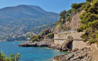
Running on the Saint-Jean-Cap-Ferrat coastal trail is one of the most spectacular runs in southern France. This run has it all: water, views, history, a bit of elevation, and few cars. Saint-Jean-Cap-Ferrat, is a peninsula 10 km east of Nice. It is a favorite holiday destination, and one of the more exclusive areas of the Côte d’Azur, with its yachts gracing the port, and high-end restaurants and shops.
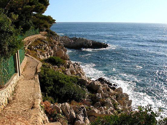
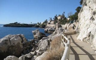
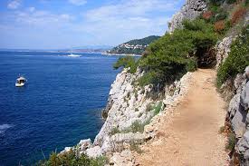 There’s a gorgeous coastal trail that goes down to Cap Ferrat and most of the way around the peninsula. a distance of some 6.5 km. On the eastern side, it is called Chemin de la Carrière, and on the western side it is Chemin des Douaniers. There are water views much of the way, with spectacular homes (often blocked by hedges or fences) on the inside. The width of the trail varies and is a bit narrow in spots. The surface also varies — some sections are gravel, others a bit rocky, and occasionally a bit sandy. But very runnable. There is some altitude gain on this route. The part of the route in town takes you along the seaside promenade and port, with wonderful restaurants, and yacht-viewing.
Features:
Scroll Down For Route Maps
Essentials
- 6.5 km (4 miles)
- 280 feet
- Can start in the center of town - Tourist Office, port.
- Accessible by car. Train: Beaulieu-sur-Mer, 3 km north of Cap-Ferrat, then take 81 Bus
Current Weather & Forecast
Location Weather
Please set your valid city name and country code.
Other Routes in Côte d'Azur, France

Some good running in this popular visitor destination. Good options include a waterfront/Citadel loop, a trail run along the Sentier Littoral, beach running on Plage de Tahiti & Plage de la Pampelone, or a castle route in the historic village of Grimaud.

A wonderful waterside run in Cannes, site of the famous film festival, and many shops & restaurants. The most famous section is 4.5 km along the Boulevard de la Croisette, but you can continue for another 7 km along the Boulevard du Midi to the Pullman Casino.
A lovely peninsula in the Côte d'Azur, with several good running options. Waterside running on the western side near Juan-les-Pins; south from Antibes to Garoupe Beach, or 'run the peninsula' for 7.7 km, with water views most of the way.

Several great running routes in Nice, the unofficial capital of the The Côte d’Azur. Includes the Promenade des Anglais, Mont Boron Park, and coastal routes to Antibes and Villefranche-Sur-Mer.
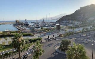
A dedicated waterfront path for 2.5 km between Mala and Cap d'Ail. Another section of the 'Sentier Littoral', with great views. Do it at sunrise! Can be combined with Monaco run, or other sections. Train station in Cap d'Ail.
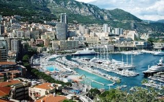
A 5+ mile runseeing tour of Monaco and Monte Carlo. This one's a real mix: beautiful seaside promenades, busy streets, hills, casinos, and fancy hotels. We've mapped out a route featuring the highlights of the area, with the best paths and roads for running.

Scenic coastal path that winds around Cap Martin for 4 km. Mostly above the water, with great views. Paved, but hillier and more rugged than some of our other Côte d’Azur coastal routes.
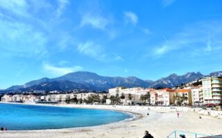
Long, open, and pleasant waterfront run for up to 6.4 km between Roquebrune-Cap-Martin and Menton. It's a mix of dedicated waterfront promenade and wide, palm-lined sidewalk along the D52 road.
Just a short train ride from Nice or Monaco, enjoy the lovely seafront promenade in Ventimiglia & Bordighera. Great water views and a festive scene with numerous beaches, shops, eateries, & an outdoor market. Up to 6 km one-way.
User Ratings
Leave A Review or Comment
Review or Comment on This Route/Share a Photo!
Share your feedback on this route and see that of other Great Runs users. Click on the image icon to upload a photo. And please let us know if there are notes or changes we should incorporate!