Features:
Categories:
Cape Breton Island is a large island in northern Nova Scotia, known for the scenic Cabot Trail coastal drive. This rugged island is very hilly, so runners will have to find their spots. Unfortunately, we can’t recommend most of the Cabot Trail road (NS-30) for running, as it’s generally VERY hilly and also has very little shoulder. In summer, there are quite a number of cars and RVs. We have researched a few scenic, runnable spots on Cape Breton (see our separate post for Sydney running options):
Ingonish Area: This area is flatter and there are some nice running options off the main road. At Ingonish Beach, there’s a nice 4 km loop from the Ingonish Visitor Center to Ingonish Beach Rd. Note there’s a trail between Park Headquaters Ln. and the lake that’s not on maps but very runnable. ROUTE MAP.
The Middle Head Trail is an easier, runnable trail that’s ~2 km one-way, starting near the famous Cape Breton Highlands Links.

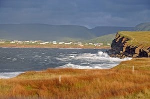
Chéticamp Area. This fishing village on the western side of Cape Breton is also a flatter area with some decent running off the main road. There are 3-4 km along the main road, NS-30, on a sidewalk/path with some nice water views, including the scenic De Lances des Boise Marine at the northern end. Another great option is Chéticamp Island. One can run on the shoreline along Du Phare Rd. for up to 8 km one-way, with beautiful water views and lovely open terrain. Use this ROUTE MAP to design a route of preferred length!

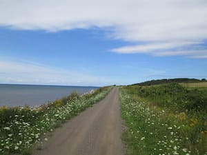
The Celtic Shores Coastal Trail. A 92 km (57 mi) multi-use trail, along former rail bed, stretching from Port Hastings to Inverness on the west coast of Cape Breton Island. An easy, flat trail that’s a great option for an off-road distance run. The terrain includes some coastline and harbor sections, woods, and some more remote areas. The surface is smooth and hard-packed. There are numerous access points. The park website shows the trail divided into five sections, with numerous downloadable maps. The more coastal sections are the 30 km between Canso Canal (Port Hastings) and Judique. WEBSITE OVERVIEW MAP


Comment on this Route/Share a Photo!
Share your feedback on this route and see that of other Great Runs users. Click on the image icon to upload a photo. And please let us know if there are notes or changes we should incorporate!