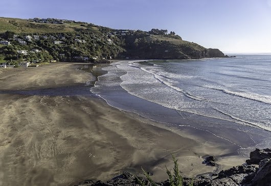
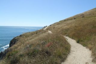
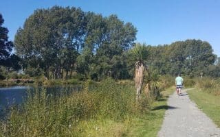
The Taylors Mistake/Boulder Bay area, located 30 minutes southeast of Christchurch, is a gorgeous area to explore on foot. This is an easy to moderate trail run along what’s known as the Godley Head Walkway, consisting of a more gentle coastal path along Taylors Mistake Beach (a popular beach area), yielding to the slightly more challenging Boulder Bay Walkway, with ups and downs above the water leading out to Godley Head. There’s a lighthouse and remnants of WW2 fortifications. There are numerous additional — and more challenging — trails in the area for those who like. We’ve mapped an 8.5 km out and back route from Taylors Beach to the Godley Head car park, but a 6.6 km out and back option saves a more challenging climb.
Starting at Taylors Mistake Beach car park off Taylors Mistake Rd., the first section is a 1.4 mile out and back heading west on the Taylors Mistake Bay path, along the beach. This part is easy and flat. Then, head east toward Godley Head, on the Boulder Bay Walkway. There are a couple of ups and downs here, but it is runnable. At the 2.7 km mark, reach Harris Bay Cave.
Godley Head Trail (Freewalks.NZ)
Shorter, Easier Option: After another 1.3 km past Harris Bay Cave (~4 km mark), the route gets hillier and more challenging — this would be a good spot to turn around, making for a 6.6 km out and back.
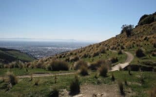
Longer, More Challenging Option: Continue along the walkway, turning right and continuing toward the Godley Head Car Park (known as Jacobs Ladder), for a climb of ~ 1 km, rising 120m. There are additional trails in the area for even more exploring. For the return, retrace your steps. Alternative Return: you can use the trail known as The Anaconda, which parallels Summit Rd. It is windy, hilly, and mre challenging, popular with mountain bikers.
The Taylors Mistake/Boulder Bay area, located 30 minutes southeast of Christchurch, is a gorgeous area to explore on foot. This is an easy to moderate trail run along what’s known as the Godley Head Walkway, consisting of a more gentle coastal path along Taylors Mistake Beach (a popular beach area), yielding to the slightly more challenging Boulder Bay Walkway, with ups and downs above the water leading out to Godley Head. There’s a lighthouse and remnants of WW2 fortifications. There are numerous additional — and more challenging — trails in the area for those who like. We’ve mapped an 8.5 km out and back route from Taylors Beach to the Godley Head car park, but a 6.6 km out and back option saves a more challenging climb.
Starting at Taylors Mistake Beach car park off Taylors Mistake Rd., the first section is a 1.4 mile out and back heading west on the Taylors Mistake Bay path, along the beach. This part is easy and flat. Then, head east toward Godley Head, on the Boulder Bay Walkway. There are a couple of ups and downs here, but it is runnable. At the 2.7 km mark, reach Harris Bay Cave.
Godley Head Trail (Freewalks.NZ)
Shorter, Easier Option: After another 1.3 km past Harris Bay Cave (~4 km mark), the route gets hillier and more challenging — this would be a good spot to turn around, making for a 6.6 km out and back.
Longer, More Challenging Option: Continue along the walkway, turning right and continuing toward the Godley Head Car Park (known as Jacobs Ladder), for a climb of ~ 1 km, rising 120m. There are additional trails in the area for even more exploring. For the return, retrace your steps. Alternative Return: you can use the trail known as The Anaconda, which parallels Summit Rd. It is windy, hilly, and mre challenging, popular with mountain bikers.
Scroll Down For Route Maps
Essentials
Full route is 8.5 km out and back. A 6.6 km out and back eliminates a major hill climb
Full route is 274m (901 feet); The shorter option eliminates a steep, 120m hill climb
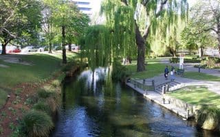
A green and pleasant river run of nearly 12 km, from central Christchurch to the estuary in New Brighton. A mix of dedicated path, some road sections, and some shared paths. Numerous parks along the way. Can do a one-way and use bus!
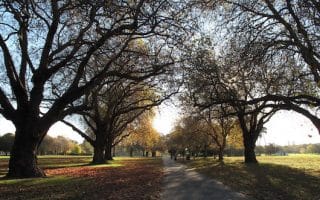
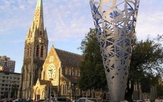
A classic urban park, featuring numerous paths for walking and running, a botanical garden, a small lake, and other sports facilities. One can easily put together a run of 10 km or more incorporating the paths. Easily accessible from downtown.
A green and pleasant river run of nearly 12 km, from central Christchurch to the estuary in New Brighton. A mix of dedicated path, some road sections, and some shared paths. Numerous parks along the way. Can do a one-way and use bus!
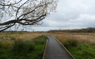
Lovely loop around the perimeter of a preserved wetland area, ~10 km northeast of Christchurch. The 4.2 km route is on gravel paths and boardwalks, with great views and pleasant landscaping. Can connect to Avon River paths for a longer run.
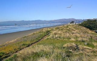
Up to 20 km of spectacular running on a wide, flat beach. The beach generally has firm, compact sand, and there are great views of Pegasus Bay and the South Pacific. There are also some trails alongside the beach, in sections.
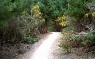
An extensive pine plantation runs along the coast in the northeast part of Christchurch. There are numerous forested trails, and a more open trail above the beach, with nice views. There are dedicated tracks for walking/running.
For some gentler trail running, there's an extensive network of paths (tracks) along the Waimakariri River, north of Christchurch. It's an area of wetlands, salt marches, and farms, with numerous interconnected trails.
The Port Hills area, located south of the city in the Cashmere Hills, offers a wealth of trail running opportunities for all levels. The trails are a combination of farmland/grassland, and some woods. Most trails are fairly hilly.
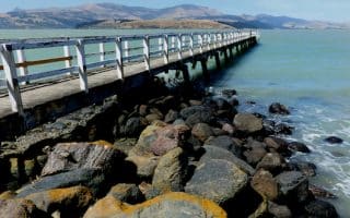
A pleasant waterfront path called the Governors Bay Foreshore Walkway (Track) runs for 3 km to the Allandale Reserve. Nice views of the bay along this flat gravel path.
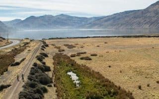
A nice opportunity for a long, flat off-road run, some along the water. We've mapped 20 km of this 50 km trail, from Motukarara to the end of Lake Forsyth. The most scenic sections are ~4 km along Lake Ellesmere, and 4.5 km along Lake Forsyth.
Share your feedback on this route and see that of other Great Runs users. Click on the image icon to upload a photo. And please let us know if there are notes or changes we should incorporate!
Subscribe
0 Comments
Oldest
Newest
Inline Feedbacks
View all comments
Essentials
Full route is 8.5 km out and back. A 6.6 km out and back eliminates a major hill climb
Full route is 274m (901 feet); The shorter option eliminates a steep, 120m hill climb

Review or Comment on This Route/Share a Photo!
Share your feedback on this route and see that of other Great Runs users. Click on the image icon to upload a photo. And please let us know if there are notes or changes we should incorporate!