Unfortunately, there aren’t a lot of dedicated waterfront promenades for running on Corsica. The main roads running closer to the water — the T10 on the eastern side, and the D81 on the western side — are fairly busy, with no shoulder or sidewalk except for small sections in the main towns. Also, they tend to be just inland from the water in many sections, and are hilly. Even so, there are a few sections with some scenic and safe waterfront running on Corsica. Our recommendations:
Bastia/Biguglia area: A cycle path runs alongside the Marana Beach and lagoon in Biguglia. It goes for 7.7 km along the Rt. de Lagune. Some nice water views. ROUTE MAP
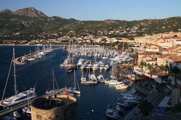
Calvi Area. About 2 km around the port & marina area, including the Citadelle. There’s also some gorgeous, easier trail running on the Belvedere hiking trail all the way to the Plage de l’Alga.
Ajaccio Waterfront. Ajaccio, the port city and capital on the western coast, features some of the longest, most scenic, and safest waterfront running on Corsica. From the port, there’s ~2 km of dedicated waterfront path along the marina, around the Citadelle, to the Piazza Miot. From there, you can run along the D11 for ~11 km all the way to Parata Tower. There’s a decent sidewalk for 8 km to Plage Terre Sacrée (beach). From there, there’s a soft shoulder along the road — it can be sandy. At the Parata Tower, there are several km of very scenic, easy-to-moderate trail running around the Pointe de La Corba. ROUTE MAP
Propriano. About ~2 km of running around the marina/port. Unfortunately, there’s no sidewalk or shoulder on the scenic D319 road just outside of town. You could run it at quiet times.
Bonifacio. Some nice waterfront running in this town on the southern tip of Corsica. One can stitch together a ~6 km run along the marina path, then past the Citadel, out to the Saint-Antoine Grotto, and then to the Affacatoghju d’I Tippaddi fort. Very scenic and hilly! There’s also some hiking/moderate trail running on trails east of Bonifacio, to the lighthouse atop Mt. Pertusato, with great views of the Mediterranean. ROUTE MAP
Porto-Vecchio. Put together a 4-5 km run in this port town on the southeast coast. Includes 2-3 km along the quai/marina, and then a hilly loop around the 16th-century Genoese citadel. ROUTE MAP
Saint-Florent. In this pretty fishing port town, one can put together a scenic run of ~8 km, with three elements: A waterfront path along the Quai, a tour of the Citadel, paths by the marina, and then a lovely, quiet road on the west side of the river that leads into the Golf of Saint-Florent. The section around the Citadel is, predictably, hilly! ROUTE MAP
Unfortunately, there aren’t a lot of dedicated waterfront promenades for running on Corsica. The main roads running closer to the water — the T10 on the eastern side, and the D81 on the western side — are fairly busy, with no shoulder or sidewalk except for small sections in the main towns. Also, they tend to be just inland from the water in many sections, and are hilly. Even so, there are a few sections with some scenic and safe waterfront running on Corsica. Our recommendations:
Bastia/Biguglia area: A cycle path runs alongside the Marana Beach and lagoon in Biguglia. It goes for 7.7 km along the Rt. de Lagune. Some nice water views. ROUTE MAP
Calvi Area. About 2 km around the port & marina area, including the Citadelle. There’s also some gorgeous, easier trail running on the Belvedere hiking trail all the way to the Plage de l’Alga.
Ajaccio Waterfront. Ajaccio, the port city and capital on the western coast, features some of the longest, most scenic, and safest waterfront running on Corsica. From the port, there’s ~2 km of dedicated waterfront path along the marina, around the Citadelle, to the Piazza Miot. From there, you can run along the D11 for ~11 km all the way to Parata Tower. There’s a decent sidewalk for 8 km to Plage Terre Sacrée (beach). From there, there’s a soft shoulder along the road — it can be sandy. At the Parata Tower, there are several km of very scenic, easy-to-moderate trail running around the Pointe de La Corba. ROUTE MAP
Propriano. About ~2 km of running around the marina/port. Unfortunately, there’s no sidewalk or shoulder on the scenic D319 road just outside of town. You could run it at quiet times.
Bonifacio. Some nice waterfront running in this town on the southern tip of Corsica. One can stitch together a ~6 km run along the marina path, then past the Citadel, out to the Saint-Antoine Grotto, and then to the Affacatoghju d’I Tippaddi fort. Very scenic and hilly! There’s also some hiking/moderate trail running on trails east of Bonifacio, to the lighthouse atop Mt. Pertusato, with great views of the Mediterranean. ROUTE MAP
Porto-Vecchio. Put together a 4-5 km run in this port town on the southeast coast. Includes 2-3 km along the quai/marina, and then a hilly loop around the 16th-century Genoese citadel. ROUTE MAP
Saint-Florent. In this pretty fishing port town, one can put together a scenic run of ~8 km, with three elements: A waterfront path along the Quai, a tour of the Citadel, paths by the marina, and then a lovely, quiet road on the west side of the river that leads into the Golf of Saint-Florent. The section around the Citadel is, predictably, hilly! ROUTE MAP

Review or Comment on This Route/Share a Photo!
Share your feedback on this route and see that of other Great Runs users. Click on the image icon to upload a photo. And please let us know if there are notes or changes we should incorporate!