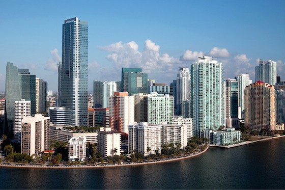
The running options in downtown Miami aren’t fantastic. It’s congested and car-centric, with hotels and apartment buildings blocking what could be a more seamless and scenic waterfront route. However, it is possible to put together a decent waterfront run of several miles, with a few less pleasant connection points. We’ve broken our route into three parts, which can be done as a longer run or in sections. The longer run is ~6 miles, between Rickebacker Causeway and MacArthur Causeway /Maurice A. Ferré Park. One option: run the 6.4 miles from Rickenbacker Causeway north to Maurice A. Ferré Park and take the light rail back!
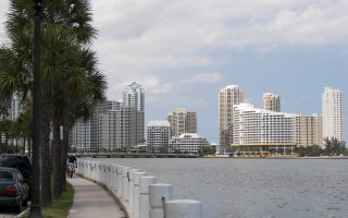
Brickell Route –Rickenbacker Causeway to Brickell Point. 3.6 miles one-way. Brickell is Miami’s financial center, lined with large towers and condos. From the Rickenbacker Causeway, it’s about 2.5 miles through the Brickell area. Decent sidewalk along RT. 1, and then follow Brickell Bay Dr., with a couple of nice waterfront sections, to Brickell Key Dr., for a ~1 mile loop around Brickell Key.
Bayfront Park. Wikimedia Commons
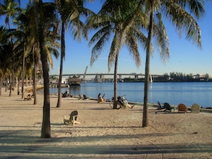
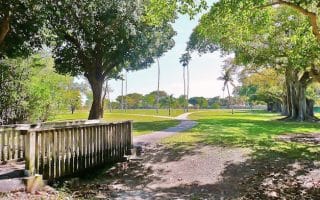
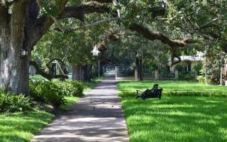
Brickell Point to Maurice A. Ferré Park. 2.8 miles one-way. This is the nicest and most seamless section. From Brickell Point, take the scenic Brickell Ave. Bridge, and then run along the Miami Riverwalk to the Bayfront Path and through lovely Bayfront Park. Then, loop around the American Airlines arena and continue along the water on the Baywalk Path to Maurice A. Ferré Park. Longer run: connect to our Venetian Causeway route.
Riverwalk Path. 1.1 miles one-way. This path runs on the north side of the Miami River, from Bayfront Park to just past the 2nd Ave. Bridge. There are a couple of interrupted sections. One can also run on the south side of the river, but not the whole way. This path is a bit of a work in progress, with continued improvements/expansion, but also construction requiring detours.
The running options in downtown Miami aren’t fantastic. It’s congested and car-centric, with hotels and apartment buildings blocking what could be a more seamless and scenic waterfront route. However, it is possible to put together a decent waterfront run of several miles, with a few less pleasant connection points. We’ve broken our route into three parts, which can be done as a longer run or in sections. The longer run is ~6 miles, between Rickebacker Causeway and MacArthur Causeway /Maurice A. Ferré Park. One option: run the 6.4 miles from Rickenbacker Causeway north to Maurice A. Ferré Park and take the light rail back!
Brickell Route –Rickenbacker Causeway to Brickell Point. 3.6 miles one-way. Brickell is Miami’s financial center, lined with large towers and condos. From the Rickenbacker Causeway, it’s about 2.5 miles through the Brickell area. Decent sidewalk along RT. 1, and then follow Brickell Bay Dr., with a couple of nice waterfront sections, to Brickell Key Dr., for a ~1 mile loop around Brickell Key.
Bayfront Park. Wikimedia Commons
Brickell Point to Maurice A. Ferré Park. 2.8 miles one-way. This is the nicest and most seamless section. From Brickell Point, take the scenic Brickell Ave. Bridge, and then run along the Miami Riverwalk to the Bayfront Path and through lovely Bayfront Park. Then, loop around the American Airlines arena and continue along the water on the Baywalk Path to Maurice A. Ferré Park. Longer run: connect to our Venetian Causeway route.
Riverwalk Path. 1.1 miles one-way. This path runs on the north side of the Miami River, from Bayfront Park to just past the 2nd Ave. Bridge. There are a couple of interrupted sections. One can also run on the south side of the river, but not the whole way. This path is a bit of a work in progress, with continued improvements/expansion, but also construction requiring detours.
Scroll Down For Route Maps
Essentials
Rickenbacker Causeway to Ferré Park is 6 miles one-way, but can be done in sections; Riverwalk is 1.1 miles one-way
Fairly flat
Depends on section chosen.
A light rail line runs just west of Brickell Ave./ Biscayne Blvd.
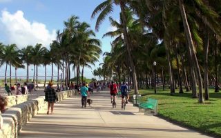
One of the great urban beaches and one of the more scenic and festive runs in Florida. The wide, paved Boardwalk runs for 8 miles along (runnable) Miami Beach. Take in palm-lined parks, beach & ocean views, Art Deco architecture, the Miami skyline, & fun shops & restaurants.
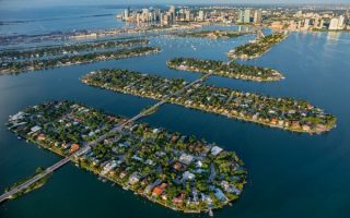
Key Biscayne is an island connected to the southern part of Miami, connected by the Rickenbacker Causeway. Two best runs are over the Causeway via a path, trails and beach in Crandon Park, and Virginia Key, with 4+ miles of trails.
A major improvement to the downtown Miami running scene. Modeled after NYC's Highline Trail, this paved linear park path runs underneath the Metrorail for 2.8 miles, with plans to extend to 10 miles by 2026. Numerous amenities & features.
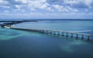
There are several bridges and long causeways connecting the unique geography of the Miami area. The most interesting and runnable one is Venetian Causeway, which is 3 miles one way between Miami and Miami Beach.
At 1,043 acres, this is Florida’s largest urban park. There are 14 miles of recreational trails, highly used for mountain biking. Best bet option for runners is the 3-mile paved trail or the 4-mile ‘novice’ biking trail.
Situated between Miami and Hollywood, Amelia Earhart Park is a good destination spot for those who'd like a longer off-road running opportunity. This 515-acre park contains 5 lakes and several miles of trails that are great for running.
Pleasant spot for a run, 4 miles north of downtown Miami and near I-195. About 1 mile of shaded, paved trails in the park. Nice water views as well. The residential neighborhood just west of the park is nice for running.
One of the nicest neighborhoods in Miami. Very lush and green. A pleasant run in Coconut Grove incorporates some of the residential streets, with beautiful vegetation, grand old homes, and some waterfront sections.
A nice option connecting some of the pleasant street, paths, and parks of Coconut Grove. Start at Peacock Park and run through Kennedy Park, about 3 miles to Brickell, and back.
An older, upscale residential neighborhood just west of Miami. Lovely parks and gorgeous, tree-lined streets with historic homes well set back from the road. Take our 8-mile tour and/or create your own route in the residential area. Running track at Tropical Park.
National Park southwest of Miami with 1.5 million acres of wetland. Some of the best spots for running are the Shark Valley Bike Trail, Pinelands trails, and the Flamingo area trails.
Share your feedback on this route and see that of other Great Runs users. Click on the image icon to upload a photo. And please let us know if there are notes or changes we should incorporate!
Subscribe
0 Comments
Oldest
Newest
Inline Feedbacks
View all comments
Essentials
Rickenbacker Causeway to Ferré Park is 6 miles one-way, but can be done in sections; Riverwalk is 1.1 miles one-way
Fairly flat
Depends on section chosen.
A light rail line runs just west of Brickell Ave./ Biscayne Blvd.


Review or Comment on This Route/Share a Photo!
Share your feedback on this route and see that of other Great Runs users. Click on the image icon to upload a photo. And please let us know if there are notes or changes we should incorporate!