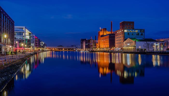
The riverside city of Duisburg is located a mere 20 kilometers west of Essen (just 15 minutes by train). There are plenty of terrific places to run in Duisburg, from a ‘runseeing’ tour of the Altstadt and Inner Harbor to routes along the Rhine and Ruhr Rivers, the modern Landschaftspark, and some lake trails south of the city.
Duisburg Center and Inner Harbor:
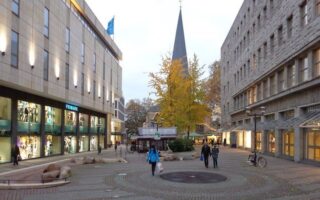
Runners will find plenty of good route options right in the center of Duisburg (mainly in the Altstadt). There is a fine pedestrian-only strip along the Königstraße, just outside the Duisburg König-Heinrich-Platz station. From here, runners can venture south into Immanuel Kant Park and north to Alstadt Park and the Duisburg Inner Harbor. We’ve mapped a 6 km loop incorporating all the best streets and sights. ROUTE MAP.
Rhine River:
Duisburg is located along the east banks of the Rhine River, so it’s no surprise that the waterfront features some of the best running in the city. While there are no continuous paths along the River, good sections can be found just northwest of the center at Rheinorange, Spielplatz, and across the river near Plange Mühle Kran. We’ve mapped a grand ~22 km loop from Duisburg Ruhrort station that outlines some of the possibilities. ROUTE MAP.
Ruhr River:
A section of the Ruhr River also flows through Duisburg, heading towards Essen. There are paths between the mouth at the Rhine and where the river splits into the Rheine-Herne-Kanal. One favorite section, starting just north of the inner harbor is around the Ruhrschleuse Duisburg and Ruhrwehr Duisburg. We’ve mapped a 10k loop for reference. ROUTE MAP.
Landschaftspark:
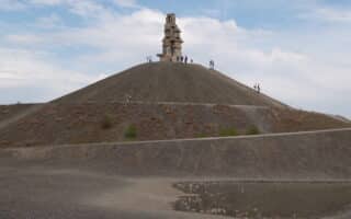
This large green space in Duisburg north is built along the Alte Emscher. It embraces the region’s industrial past, incorporating the remains of a coal and steel production plant with natural features and runnable crushed stone paths. A loop around the entire park is about 6 km, but runners can continue their route along the Gruner Pfad multi-use path (southern end of the park) in either direction. There are all sorts of paths and cycle trails. The northern part is more open, the southwestern section is more wooded. ROUTE MAP.
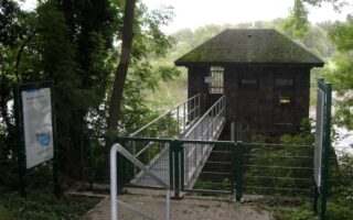
Regattabahn:
Regattabahn, or the Wedau Regatta Course, is an artificial lake south of Duisburg. While this area was specifically constructed for watersports competitions, the lakes are lined with superb crushed gravel walking paths. A loop around the Regattabahn is just short of 5k. Great option for loops and fartleks! ROUTE MAP.
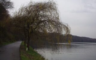
Wolfssee (Sechs-Seen-Platte):
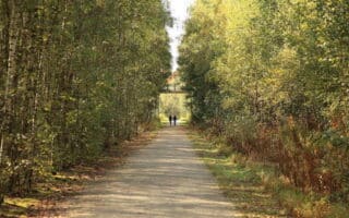
Just south of Regattabahn, runners can connect to the paths of Wolfssee, a collection of intertwined lakes encircled by a variety of smooth, wooded dirt trails. A loop around the waterfront is approximately 6.7 km. Runners can find more mileage along the Dickelsbach Canal, which winds south into Waldgebiet Grindsmark and Rahmer Benden or north into Klönecke. ROUTE MAP.
The riverside city of Duisburg is located a mere 20 kilometers west of Essen (just 15 minutes by train). There are plenty of terrific places to run in Duisburg, from a ‘runseeing’ tour of the Altstadt and Inner Harbor to routes along the Rhine and Ruhr Rivers, the modern Landschaftspark, and some lake trails south of the city.
Duisburg Center and Inner Harbor:
Runners will find plenty of good route options right in the center of Duisburg (mainly in the Altstadt). There is a fine pedestrian-only strip along the Königstraße, just outside the Duisburg König-Heinrich-Platz station. From here, runners can venture south into Immanuel Kant Park and north to Alstadt Park and the Duisburg Inner Harbor. We’ve mapped a 6 km loop incorporating all the best streets and sights. ROUTE MAP.
Rhine River:
Duisburg is located along the east banks of the Rhine River, so it’s no surprise that the waterfront features some of the best running in the city. While there are no continuous paths along the River, good sections can be found just northwest of the center at Rheinorange, Spielplatz, and across the river near Plange Mühle Kran. We’ve mapped a grand ~22 km loop from Duisburg Ruhrort station that outlines some of the possibilities. ROUTE MAP.
Ruhr River:
A section of the Ruhr River also flows through Duisburg, heading towards Essen. There are paths between the mouth at the Rhine and where the river splits into the Rheine-Herne-Kanal. One favorite section, starting just north of the inner harbor is around the Ruhrschleuse Duisburg and Ruhrwehr Duisburg. We’ve mapped a 10k loop for reference. ROUTE MAP.
Landschaftspark:
This large green space in Duisburg north is built along the Alte Emscher. It embraces the region’s industrial past, incorporating the remains of a coal and steel production plant with natural features and runnable crushed stone paths. A loop around the entire park is about 6 km, but runners can continue their route along the Gruner Pfad multi-use path (southern end of the park) in either direction. There are all sorts of paths and cycle trails. The northern part is more open, the southwestern section is more wooded. ROUTE MAP.
Regattabahn:
Regattabahn, or the Wedau Regatta Course, is an artificial lake south of Duisburg. While this area was specifically constructed for watersports competitions, the lakes are lined with superb crushed gravel walking paths. A loop around the Regattabahn is just short of 5k. Great option for loops and fartleks! ROUTE MAP.
Wolfssee (Sechs-Seen-Platte):
Just south of Regattabahn, runners can connect to the paths of Wolfssee, a collection of intertwined lakes encircled by a variety of smooth, wooded dirt trails. A loop around the waterfront is approximately 6.7 km. Runners can find more mileage along the Dickelsbach Canal, which winds south into Waldgebiet Grindsmark and Rahmer Benden or north into Klönecke. ROUTE MAP.


Review or Comment on This Route/Share a Photo!
Share your feedback on this route and see that of other Great Runs users. Click on the image icon to upload a photo. And please let us know if there are notes or changes we should incorporate!