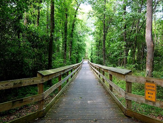
The Cape Fear River Trail is arguably the spot for running in the Fayetteville area. The wide, paved, multi-use path winds through a beautiful blend of trees, plants and wildlife. It’s mainly wooded. A highlight is the 1,000 feet of boardwalk through the marsh and wetlands. Overall, the length is 6.3 miles, though there’s a section that’s being extended at the southern end to the Riverside Dog Park, connecting to the Cross Creek Linear Park (check here for updated information). There are some sections right along the river, but generally there aren’t water views.
A good access point/parking area is at Clark Park. From there, the trail extends 1.2 miles south, or 5 miles north to Lower Field Dr. at Methodist University.
Add-Ons: Additional trails/paths at the northern end at Methodist University, including a running track at Monarch Stadium.

Review or Comment on This Route/Share a Photo!
Share your feedback on this route and see that of other Great Runs users. Click on the image icon to upload a photo. And please let us know if there are notes or changes we should incorporate!