Jekyll Island is the southernmost of the Golden Isles, at 5,700 acres and popular with visitors. Originally a retreat of the wealthy, the island was acquired by the state in 1947, which has protected all but 1,600 acres from development. It is 8 miles north-south. Running on Jekyll Island is a treat, with pretty neighborhoods, a gorgeous beach, and 25 miles of bike paths. We don’t recommend Jekyll Island Causeway, as there is very little shoulder. The best places to run on Jekyll Island are below. Note: See comments section for some more details.
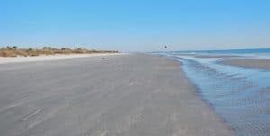 Jekyll Island Beach. This is the highlight of running on Jekyll Island. About 10 miles of nearly continuous beach, with hard packed sand great for running. It’s divided into Driftwood Beach, Glory Beach, and St. Andrews Beach, with many numbered access points. Note some sections might not be as accessible/runnable at high tide, particularly toward the northern end.
Ocean View Trail. One of the most attractive sections of the bike path that runs along Beachview Dr., this paved, 2-mile section runs alongside the beach for 2 miles in Great Dunes Park, just off the causeway (Rt. 520). It goes from the Days Inn, to just north of the Holiday Inn. MAP
Beachview Drive. A path runs along Beachview Dr. for 8+ miles south-north. There are water views for some of the way, but the best section is the Ocean View Trail, (above) which comes off Beachview Dr.
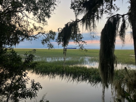
North Loop Trail. Beautiful, paved trail runs for 1.5 miles through a tidal marsh from the northern end of Beachview Dr. to the Jekyll Fishing Center. For a good loop, take the N. Loop Trail out and then the Driftwood Beach Trail back (not paved, might be soft sand). The final 1/3 mile is along the beach.
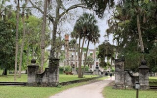
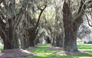
Historic District Trail/Riverview Dr./N.Loop Trail. A bike path/sidewalk parallels Riverview Dr. for nearly 6 miles. First section is the Historic District Trail, which is 2 miles one-way from the Causeway to the Presbyterian Church. Really pretty, with moss-draped oak trees and river views through the Historic Dist rict, which is a large restoration project. Then the paved N. Loop Trail is a 3.8 mile path through very pretty trees and foliage to the northern end of the island. Total is 5.8 miles. MAP
- BIG LOOP: Curl back along the eastern side of the island, following the route above: N. Loop Trail to Beachview Dr., and then along the High Tide Trail (on the beach) to the Ocean View Trail, back to the rotary (about 5 miles, for a total run of nearly 11.6 miles). MAP
Road Loop. For a fun, centrally located 4-miler on quiet interior residential streets, run north along an attractive section of the Ocean View Trail, LEFT on Captain Wylie Rd., LEFT on Old Plantation Rd., and LEFT on Shell Rd.. (which also has a path). ROUTE MAP

Review or Comment on This Route/Share a Photo!
Share your feedback on this route and see that of other Great Runs users. Click on the image icon to upload a photo. And please let us know if there are notes or changes we should incorporate!