Just a short 40 minute ride from Eldoret in a Kenyan taxi, or “matatu”, the town of Iten has a small population of 7,000. Elite runners take over half of the town’s population at times. Runners from all over the world flock to this town for the opportunity to train with the best in the world. With the Kerio Valley National Park on the edge of the town, you will see some incredible views over the edge of the Rift Valley and some world class paragliders flying off that edge.
St. Patrick High School Loop
2.1 Mile Loop. Start: St. Patrick’s High School. MAP
St. Patrick’s High School sits on the edge of Iten but for runners it is a central point to the dirt roads past the high school that continue out to the country tea farms. Many runners run as far 40 kilometers for their long runs behind St. Patrick’s. The loop we provide is a very basic two mile loop for the legs to adjust to the altitude, rocky road terrain, and steep hills of Iten. Hundreds of runners train down these clay roads. If you run as school is coming out, between 2 and 4 PM at the Iten Resting Garden, children will run by the side of a Mzungo for as long as a mile with their backpack and in their flip flops just for a laugh. Their bright energy and hospitality will certainly make your run memorable. Some of St. Patrick’s alumni students being Olympians. David Rushisha, owner of two gold medals and the world record holder over 800 meters is a proud St. Patrick’s alum.
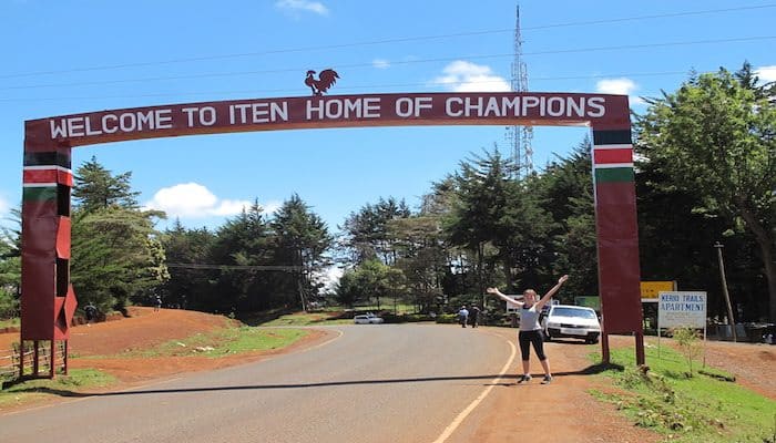
One of the most prominent figures in Iten is Kenyan turned Dutch runner Lornah Kiplagat. As an athlete, she broke the world record for 5k and 10 miles on the roads. After retiring, Lornah and her Dutch husband opened a training center for athletes all over the world to come to have access to training in Iten. Lornah Kipligat’s High Altitude Training Centre provides not just a bed and room for guests, but also a weight room, and Olympic size swimming pool. The resort is right by the famous archway, where cars coming into Iten are greeted with “Welcome to Iten. Home of Champions.” From the resort, one simply needs to walk up the hill from the guest rooms to the clay side trail and pick a direction to run in. We provide a route down to Lornah’s Mondo surfaced track, one of the new non-dirt tracks in the country.
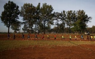
Not just some of the world’s best runners, yet also the world’s top paragliders, come to Iten to train. For these paragliders, the edge of Kerio View is a vertical jumping point to sailing across the Great Rift Valley sky. Runners too can enjoy the view and run to the edge. In fact, the dirt track at the bottom of Kamariny Stadium, where on Tuesdays hundreds of Kenyans come to train, sits close to the edge with an elevation drop of a few thousand feet to the right. The incredible sunrise seen along the rim makes for a particularly scenic early morning run. The route we included provides runners two spectacular view points, one from Kamariny Stadium and the other from the end of Kerio View Road. It’s also possible to create the run into a loop by taking a right down the trail at the end of Kerio View Road.
Bugar Forest
1.9 Miles to and from entrance into forest. Then, many options in forest MAP to forest entrance
With Kenya resting on the equator and the town of Iten situated at an altitude of just under 8,000 feet, the sun is intensely strong. A refuge for runners from the sun is the Bugar Forest, located on the outside edge of Iten near the village of Singore. Many of the runners refer to running in the forest as the “Singore run” because the entrance is near the village. The trees within the forest are tall and thickly close together, creating a dark and almost eery light on the trail compared to the open sun out on the dirt roads. The agility of some of the Kenyan runners on these switch-back style trails is remarkable. Not only do the trails zig and zag constantly, they also have humps and hills throughout, making even an easy run in the Bugar Forest quite challenging. Yet, the landscape of the tree lined trails is remarkable and the terrain maybe explains what makes the Kalenjin runners some of the best cross country runners in the world. Our route listed is simply a run along the road that will lead to the entrance of Bugar Forest. The winding trails make it easy to get lost, so keep in mind that Kapsowar Road is never too far due east.
Just a short 40 minute ride from Eldoret in a Kenyan taxi, or “matatu”, the town of Iten has a small population of 7,000. Elite runners take over half of the town’s population at times. Runners from all over the world flock to this town for the opportunity to train with the best in the world. With the Kerio Valley National Park on the edge of the town, you will see some incredible views over the edge of the Rift Valley and some world class paragliders flying off that edge.
St. Patrick High School Loop
2.1 Mile Loop. Start: St. Patrick’s High School. MAP
St. Patrick’s High School sits on the edge of Iten but for runners it is a central point to the dirt roads past the high school that continue out to the country tea farms. Many runners run as far 40 kilometers for their long runs behind St. Patrick’s. The loop we provide is a very basic two mile loop for the legs to adjust to the altitude, rocky road terrain, and steep hills of Iten. Hundreds of runners train down these clay roads. If you run as school is coming out, between 2 and 4 PM at the Iten Resting Garden, children will run by the side of a Mzungo for as long as a mile with their backpack and in their flip flops just for a laugh. Their bright energy and hospitality will certainly make your run memorable. Some of St. Patrick’s alumni students being Olympians. David Rushisha, owner of two gold medals and the world record holder over 800 meters is a proud St. Patrick’s alum.
One of the most prominent figures in Iten is Kenyan turned Dutch runner Lornah Kiplagat. As an athlete, she broke the world record for 5k and 10 miles on the roads. After retiring, Lornah and her Dutch husband opened a training center for athletes all over the world to come to have access to training in Iten. Lornah Kipligat’s High Altitude Training Centre provides not just a bed and room for guests, but also a weight room, and Olympic size swimming pool. The resort is right by the famous archway, where cars coming into Iten are greeted with “Welcome to Iten. Home of Champions.” From the resort, one simply needs to walk up the hill from the guest rooms to the clay side trail and pick a direction to run in. We provide a route down to Lornah’s Mondo surfaced track, one of the new non-dirt tracks in the country.
Not just some of the world’s best runners, yet also the world’s top paragliders, come to Iten to train. For these paragliders, the edge of Kerio View is a vertical jumping point to sailing across the Great Rift Valley sky. Runners too can enjoy the view and run to the edge. In fact, the dirt track at the bottom of Kamariny Stadium, where on Tuesdays hundreds of Kenyans come to train, sits close to the edge with an elevation drop of a few thousand feet to the right. The incredible sunrise seen along the rim makes for a particularly scenic early morning run. The route we included provides runners two spectacular view points, one from Kamariny Stadium and the other from the end of Kerio View Road. It’s also possible to create the run into a loop by taking a right down the trail at the end of Kerio View Road.
Bugar Forest
1.9 Miles to and from entrance into forest. Then, many options in forest MAP to forest entrance
With Kenya resting on the equator and the town of Iten situated at an altitude of just under 8,000 feet, the sun is intensely strong. A refuge for runners from the sun is the Bugar Forest, located on the outside edge of Iten near the village of Singore. Many of the runners refer to running in the forest as the “Singore run” because the entrance is near the village. The trees within the forest are tall and thickly close together, creating a dark and almost eery light on the trail compared to the open sun out on the dirt roads. The agility of some of the Kenyan runners on these switch-back style trails is remarkable. Not only do the trails zig and zag constantly, they also have humps and hills throughout, making even an easy run in the Bugar Forest quite challenging. Yet, the landscape of the tree lined trails is remarkable and the terrain maybe explains what makes the Kalenjin runners some of the best cross country runners in the world. Our route listed is simply a run along the road that will lead to the entrance of Bugar Forest. The winding trails make it easy to get lost, so keep in mind that Kapsowar Road is never too far due east.
One of two running epicenters of the Rift Valley, along with Iten. We feature Chepkoile, a dirt track that attracts elite runners daily; and Nangili Road, road of the 'tallest and fastest'.
Share your feedback on this route and see that of other Great Runs users. Click on the image icon to upload a photo. And please let us know if there are notes or changes we should incorporate!
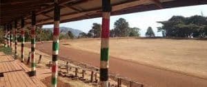 Not just some of the world’s best runners, yet also the world’s top paragliders, come to Iten to train. For these paragliders, the edge of Kerio View is a vertical jumping point to sailing across the Great Rift Valley sky. Runners too can enjoy the view and run to the edge. In fact, the dirt track at the bottom of Kamariny Stadium, where on Tuesdays hundreds of Kenyans come to train, sits close to the edge with an elevation drop of a few thousand feet to the right. The incredible sunrise seen along the rim makes for a particularly scenic early morning run. The route we included provides runners two spectacular view points, one from Kamariny Stadium and the other from the end of Kerio View Road. It’s also possible to create the run into a loop by taking a right down the trail at the end of Kerio View Road.
Review or Comment on This Route/Share a Photo!
Share your feedback on this route and see that of other Great Runs users. Click on the image icon to upload a photo. And please let us know if there are notes or changes we should incorporate!