There are a number of lovely state parks and lakes/reservoirs inland from the Shore that provide some great running options. A few of our favorites below.
Cheesequake State Park: In Matawan, near South Ambroy train station. Good trails for running through woods, marsh, and wetlands. Some hills. Length 1.5 to 3.5 miles. TRAIL MAP.
Thompson Park: In the Monmouth/Long Branch/Red Bank area. Old farm roads and a former horse exercise track are popular routes for walkers and runners. Highlights are the 4.9 mile paved trail and the 4.8 mile loop around the Reservoir. TRAIL MAP
Double Trouble State Park: A 20 minute drive from the Seaside Park area. 1.5 mile loop around a cranberry bog. Especially pretty in fall! Several other nature trails, and a historic village. TRAIL MAP
Tatum Park: In the Middletown/Red Bank area. 366-acre park with 6 miles of trails winding through rolling hills, open fields, forest, and meadows.
Brick Reservoir: A short drive from Manasquan, this is a nice 1.6 mile path around the reservoir. MAP
Manasquan Reservoir County Park: Wonderful 5-mile path along the reservoir and an extra 1.1 mile ‘Cove Trail’. 20 minute drive inland from Belmar/Avon area. Can combine with nearby Allaire State Park.
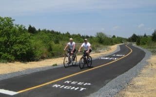
Allaire State Park: 20 miles of trails over 800 acres. Mix of wide, easy trails great for running and some more challenging trails. See the map for marked trails. One fun challenge: the 6.5 mile paved ‘Capital to Coast Trail, from the shore in Manasquan to the park, much of it on the Edgar Felix Bicycle Trail. TRAIL MAP.
Wells Mills County Park: A 20-minute drive from Long Beach Island. Nice variety of trails, mainly wooded and around a lake. TRAIL MAP
Forsythe National Wildlife Refuge – Brigantine Unit. More than 47,000 acres of coastal habitat, most of which is wetlands. An incredible birding and migratory bird protection area. At the Brigantine Unit, there’s some great running.
- Wildlife Drive offers a wonderful tour of the park, with great views of the wetlands. There are 6-mile (MAP) and 7.6-mile (MAP) loop options. Even though it’s meant as a driving tour, it’s possible to run on the road, as there’s not too much traffic and people drive slowly. Note: no shoulder or sidewalk. Also, it’s a dirt road and can get dusty.
- Hiking Trails. There are also several hiking trails, notably the Songbird Trail, partially wooded, which has 3.6 and 5 mile loop options. Trail Map


Review or Comment on This Route/Share a Photo!
Share your feedback on this route and see that of other Great Runs users. Click on the image icon to upload a photo. And please let us know if there are notes or changes we should incorporate!