
CC 3.0: Stéphane Batigne
Features:
Categories:
The best places to run in Longueuil, on Montreal’s south shore, are paved paths along the St. Lawrence River, Îles-de-Boucherville National Park, and Michel-Chartrand Park.
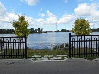
Promenade René-Lévesque. This is a paved path that runs below the road along the St. Lawrence River for 7 km, featuring some great water and skyline views. The southern end is at Parc Marie-Victorin. From there. it’s a straight shot north. There are a couple of piers/viewpoints that jut out to the water. The northern end of the path is at Bd. Marie-Victorin in Boucherville.
Îles-de-Boucherville National Park. Fantastic spot for a destination run. The park contains five small islands, featuring green spaces, channels teeming with life and waterside trails. For gentler running, there are 21 km of paved multi-use paths. There are also 15 km of more rustic trails, which are wonderful for trail running. The park is also popular for cycling, kayaking/canoeing, and XC-skiing in winter. We’ve mapped a 21 km loop of the park’s perimeter. This TRAIL MAP has additional info on trail features and distances, including some great loop options. PARK INFO
Michel-Chartrand Park. This large urban park features 10 km of crisscrossing paths and some ponds. Fairly wooded, with some open/garden areas in the interior. A loop of the park’s perimeter is ~5 km. Parking lot off Rue Adoncour. PARK MAP
Essentials
- Promenade René-Lévesque: Up to 7 km (4.4 miles) one-way; Îles-de-Boucherville NP: 21 km (14.4 miles) of multi-use paths & 15 km of more rustic trails; Michel-Chartrand Park has 10 km of trails
- Fairly flat
- Promenade René-Lévesque: Parc Marie-Victorin or other spot along path. For Îles-de-Boucherville, see info for park access
- Note: Fee required or Îles-de-Boucherville

Comment on this Route/Share a Photo!
Share your feedback on this route and see that of other Great Runs users. Click on the image icon to upload a photo. And please let us know if there are notes or changes we should incorporate!