Since L.A. is such as huge city, use this as a handy guide to get oriented. We've grouped runs by theme (beaches, canyons & parks, and boulevards/streets/tours), and by area.
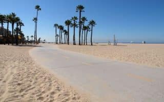
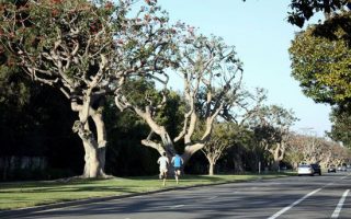
Few cities in the world rival L.A. for fantastic beach running options. This 22-mile path starts at Rogers Beach in the north, to Venice, Manhattan, and Redondo beaches, ending at Torrance Beach in the south. Includes Palisades Park in Santa Monica
One of the iconic sections of the Marvin Braude path. Starting at Santa Monica Pier, 3.3 miles to Venice Beach, ending at Washington Blvd. Includes Muscle Beach, the famed outdoor basketball courts, and Venice Skatepark.
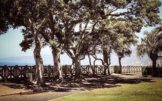
The 1.6 mile path along Pallisades Park, above the beach, is a real treat: a beautiful, palm-lined greenway with lots of star-gazing and views of the Santa Monica Pier. There are steps down to the beach, too
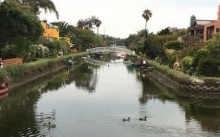
The iconic Los Angeles run -- famous Ocean Front Walk, beach, 'Grand Canal' paths, marina path all in one! We've put together a 6.5 mile loop combining these, which can be easily modified or added onto.
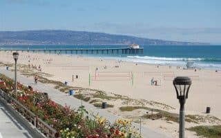
An iconic L.A. beach run and one of our favorite sections of the 22-mile Marvin Braude Trail. It's 7.4 miles between Manhattan Beach & Redondo Beach, including Hermosa Beach. A highlight is “The Strand”, which pokes out for 1 mile, affording great views. For extra cardio, do "the stairs"!
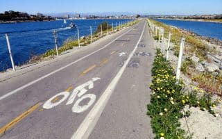
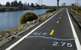
This is interesting area near the Los Angeles Airport, combining a unique and scenic trail along Ballona Creek and wetlands, and a run along the beach in Playa Del Ray.
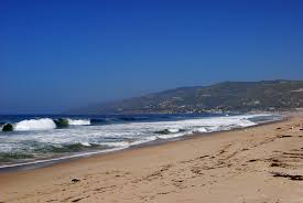
A great beach for running in Malibu. It’s about 1.5 miles one way along the Beach Access Road, or on the beach, which has fairly packed sand. Can be combined with jaunts up into the canyon trails.
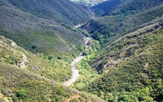
There is a wealth of running opportunities in the canyons and trails in the Malibu Area. Topanga Canyon State Park, the Encinal Trails, Zuma/Trancas Canyons. Many feature very rugged trails and steep climbs .
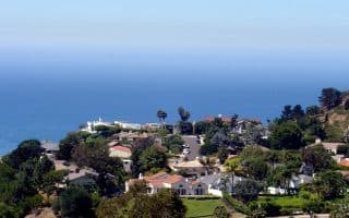
A hilly run incorporating the spectacular campus setting of Pepperdine University, views of the Pacific from Malibu Bluffs, Legacy Park, paths around the Malibu Lagoon, and a flat section along the water.
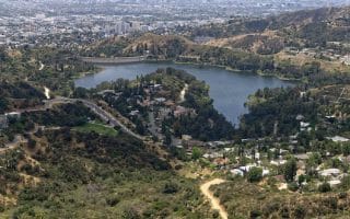
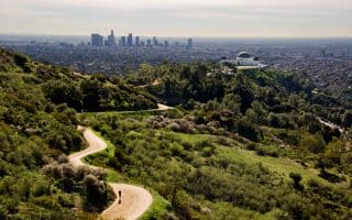
Popular running option in the Hollywood Hills area, just west of Griffith Park. Paved, 3.3 mile loop around the reservoir, with views of the water, the Hollywood sign, surrounding hills. Add on with nearby trails, Griffith Park.
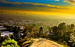
Just two blocks from Hollywood Boulevard, affording great views of the Hollywood sign, the Sunset Strip and the LA Basin. A great opportunity for running/hiking an iconic L.A. canyon within the heart of the city.
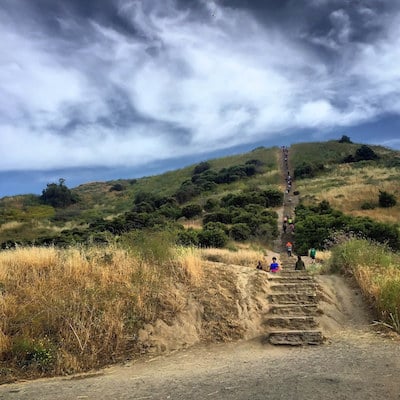
The largest municipal park with urban wilderness in the U.S., with 53 miles of trails and fire roads, many good for running. Attractions include the L.A. Zoo, Griffith Observatory, Autry National Center, and the Greek Theatre.
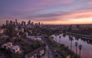
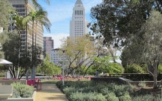
This won't be the most scenic run ever, but if you're stuck downtown or at a convention with not a lot of time to get somewhere, see our recommendations for the best downtown L.A. running spots. Best options are S. Grand Ave., L.A. State Historic Park, Elysian Park.
A large urban park in East L.A. There are many options for trails. Short run includes some of the park’s trails, including the ‘summit’, & roads around Dodger Stadium. Longer version starts from City Hall. Note: hilly and poor signage.
L.A. has a river running through it, and a very pleasant bike path along it provides a nice run and a good connection between Griffith Park, and Elysian Park/Dodger Stadium. Our map is of the ~7 mile trail in the heart of L.A.
A loop around two lakes is a running oasis in busy downtown L.A. Of the two, Echo Lake Park is prettier. It's 1.5 miles between the lakes -- not the prettiest connection, but runnable. At Silver Lake, serious hills on Baxter St. & the Mattachine Steps.
Wilshire Boulevard runs from downtown all the way to UCLA. Parts of it are quite interesting and runnable, others are very busy and not that pleasant. La Brea Tar Pits, LA County Museum.
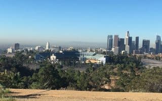
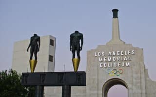
For those who get inspired by Olympics sites, it's possible to out together a decent run on the grounds around L.A. Memorial Coliseum (which served as Olympic Stadium in 1932, 1984, and 2028), the adjacent USC campus, and nearby residential streets.
Made famous by many movies and songs, Sunset Blvd. is another interesting urban run, this one through the heart of Hollywood. Wide sidewalks and numerous landmarks. Can be busy.
An iconic run in L.A. that takes you by some famous places: Electric Fountain on Wilshire Blvd., famous shops, Beverly Wilshire, Rodeo Drive, South Robertson Drive, Beverly Hills homes.
This 4.3 mile run starts out along Melrose Ave.’s , shops & restaurants,then circling through the historic L.A. Farmers Market, upscale Grove shopping center, Pan Pacific Park, and then Beverly Blvd. back.
The historic Hancock Park neighborhood is a good running option in central Los Angeles. This residential enclave, located just east of La Brea, has very pretty streets, with lovely trees, attractive homes dating back to the 1920s, and period lamps.
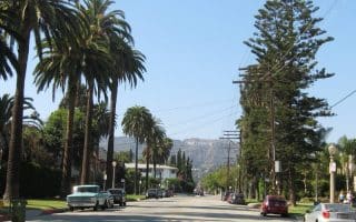
The shady, greenery-lined median of San Vicente Boulevard is a popular running spot near Santa Monica, Westwood, and Brentwood. The wide median park makes it very pleasant and roomy for runners.
A hilly run on and off Off North Beechwood Dr. where you’ll see some spectacular homes. Use that road as an anchor and meander to the other residential streets in the area. Can add 2.5 miles to the Griffith Park Observatory.
A decent off-road running option in South L.A. Magic Johnson Park, renovated in 2021, features a small lake and walking trails. A loop is 1.7 miles. Just 0.4 miles east, a paved multi-use path runs along Compton Creek for 3 miles.
Not scenic, but a good off-road running option in South L.A. This new 'Rail to Rail' trail opened in 2026 is a flat, paved multi-use path runs for 5.5 miles between the Fairview Heights Station in Inglewood and the Slauson Station in Compton.
The Sepulveda Basin Recreation Area is one of the best places to run in north L.A. Located in Burbank near the I-101/I-405 intersection, there are 7-8 miles of runnable paths, including a 1.3-mile loop around Lake Balboa and a 3.4-mile loop around a golf course.
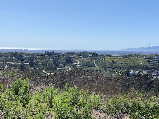
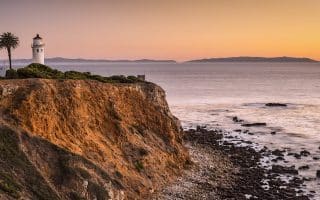
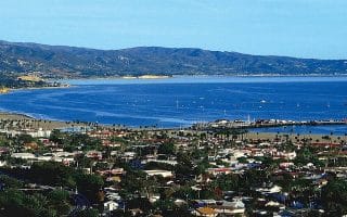
The Palos Verdes Peninsula offers significant opportunities for running. There are some great roads with incredible ocean views, and a huge network of trails, some suitable for running, others more rugged.
The greater L.A. area stretches far and wide. Here are a few great runs in Pasadena, Santa Barbara, Orange County/Irvine, Laguna Niguel, and Newport Beach
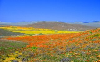
A true 'destination run'. Eight miles of scenic trails through Mojave Desert Grassland habitat, with views to the San Gabriel Mountains. Particularly special during blossom season, especially its famous poppies.


Review or Comment on This Route/Share a Photo!
Share your feedback on this route and see that of other Great Runs users. Click on the image icon to upload a photo. And please let us know if there are notes or changes we should incorporate!