Features:
Categories:
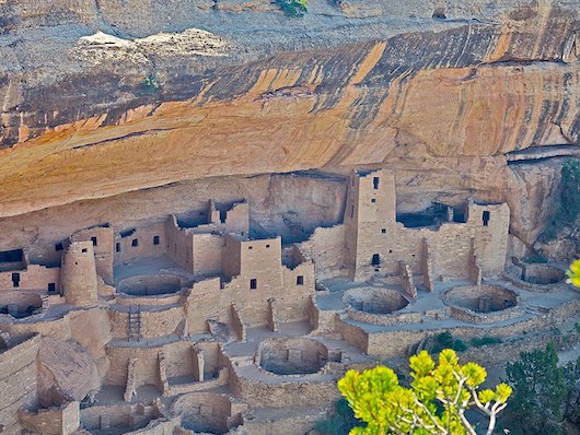
Mesa Verde National Park is located in southwestern Colorado near the New Mexico border. This World Heritage Site is an incredible glimpse into the communities that the Pueblo people built on the mesas and in the cliffs. It’s a landscape of sloping mesas, expansive vistas, and rugged canyons. There are some good options for running in Mesa Verde National Park, mainly on the 30 miles of hiking trails rated easy to moderate. Our recommendations in the three main areas of the park — Morefield Canyon, Chapin Mesa, and Wetherill Mesa — are below. Note: Runners should be aware that Mesa Verde NP is at 7,000 feet.
Main Park Road
We don’t recommend running the main park road. There is not a shoulder, and there are some very steep sections. Intrepid runners can run it but we recommend doing it off-season or in times of little traffic.
Morefield Canyon Area
- Knife Edge Trail. 2 mile loop, 60 foot gain. Follows a section of the historic park road.
Chapin Mesa
- Soda Canyon Overlook Trail. 1.2 mile loop, 70 foot gain. A level out-and-back trail that winds through pinyon-juniper forest to three overlooks.
Wetherill Mesa
- Long House Loop. 5 mile loop, 177 foot gain. Probably the best option for running in Mesa Verde NP. This paved trail loops around the top of Wetherill Mesa. ROUTE MAP
From the Long House Loop, runners can add on with the Badger House Community Trail (Moderate, 2.5 miles RT, 111 foot gain), Nordenskiold Site No. 16 Trail (Moderate, 2 miles RT, 85 foot gain), Long House Overlook (3 miles RT) and Kodak House Overlook (4.5 miles RT).


Comment on this Route/Share a Photo!
Share your feedback on this route and see that of other Great Runs users. Click on the image icon to upload a photo. And please let us know if there are notes or changes we should incorporate!