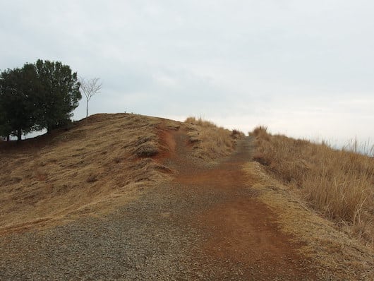
Just east of the central section of Nara and Nara Park is a large preserve with hilly paths leading up Mt. Wakakusa, around Mt. Kasuga, and the Kasugayama Primeval Forest. It’s scenic, and quite shaded. There are numerous options for hiking/walking/running here, although we note it this is a very hilly and challenging run. Here are some recommendations:
Kasugayama. Wikimedia Commons
Full Loop. Start at Nara Park and use the paths through a more open area to run the 1.5 km to the summit of Mt. Wakakusa, climbing 150m (alternative: parking lot at top). From there, run on the Shinwakakusayama Driveway (gravel road). At the 4 km mark, optional 1 km out and back to the Hakuryu Shrine. Continue along the road. At the 6.2 km park, take gravel path that heads back west for 2 km through the Kasugayama Primeval Forest preserve to the Nara National Museum (there’s either a windy path to the Kishibosonjin Temple, or a path along Noto River). The winding trail leads through ancient forests of cedar, oak and maple. Especially pretty in autumn!
Mt.Wakakusa Loop. For a shorter option, just to the route to the summit of Mt. Wakakusa. From the same start, take the path to the summit, and then take the gravel, wooded path that comes off the parking lot back down. This is half the distance and half the elevation gain as the longer loop.
Scroll Down For Route Maps
Essentials
Full loop: 10.5 km (6.5 miles); Mt. Wakakusa Loop: 4.8 km (3 miles)
A scenic running tour of Nara's principle sites, including Nara Park, iconic gardens, and numerous shrines and temples. Use our mapped route as an outline to create your own route on the paths and grounds around these sites.
A few km west of Nara Park, our 8 km route featuring the grounds of Heijō Palace and paths around three lagoons just northeast of there make for a nice run, combining historical sites and some pleasant waterside roads.
Naraden Field is the anchor of the Nara Sports complex. Decent running around numerous paths, fields, a small pond, and two running tracks. A good spot to practice intervals! Located ~1.5 km north of central Nara.
Share your feedback on this route and see that of other Great Runs users. Click on the image icon to upload a photo. And please let us know if there are notes or changes we should incorporate!
Subscribe
0 Comments
Oldest
Newest
Inline Feedbacks
View all comments
Essentials
Full loop: 10.5 km (6.5 miles); Mt. Wakakusa Loop: 4.8 km (3 miles)


Review or Comment on This Route/Share a Photo!
Share your feedback on this route and see that of other Great Runs users. Click on the image icon to upload a photo. And please let us know if there are notes or changes we should incorporate!