Jamestown, the second largest island in Narragansett Bay, is located 5 miles from Newport using the Claiborne Pell Bridge or from Kingston using Jamestown Bridge. It’s a popular summer colony, home to farms, three state parks, and numerous small beaches. With a population of only 6,000, there’s not a lot of traffic, so running on Jamestown’s roads is generally safe. It’s ~9 miles north-south and ~1 mile east-west. Below are our recommendations on the best places to run in Jamestown, which can be mixed & matched. Notes: Pedestrians aren’t permitted on either of the two bridges to Jamestown.Most of the main roads on Jamestown don’t have a sidewalk/shoulder but there’s generally not too much traffic. Also, there’s a seasonal Ferry from Newport.
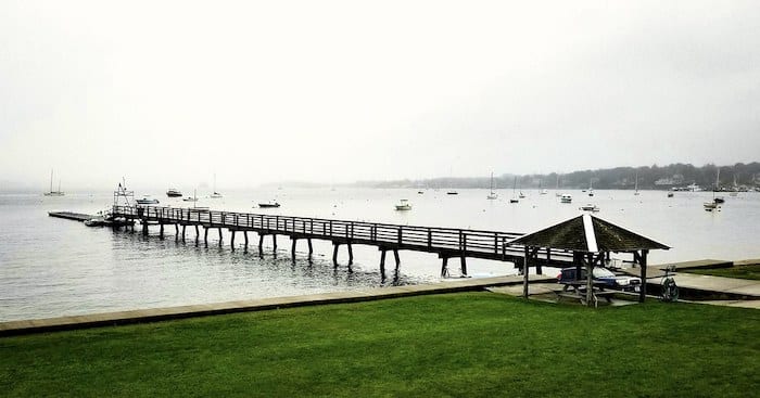
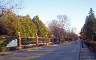
Best Run with Ocean Views. The most scenic stretch for running in Jamestown is along Canonicus Ave., near the small historic center on the island’s east side. From the center of town, head south as far as Fort Wetherill Rd. and north to the Jamestown Golf Course. There are great water views, and some gorgeous homes. For a longer run, do a loop around Fort Wetherill State Park, which has great views. In town, it’s enjoy the shops, restaurants, and nice homes along Narragansett Ave., which runs for 1 mile between the east and west sides of the island. It’s also fun to explore some of the quiet residential streets near town. ROUTE MAP
Beavertail State Park. Wikimedia: Leonardo Dasilva
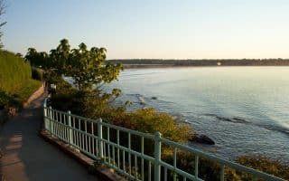
Fort Getty Park & Beavertail State Park. A nice run on generally quiet roads, mixing some historic spots and coastal views. From the parking lot at the park, it’s a ~1 mile tour of the walking paths, with some nice views. Then run out Fort Getty Rd. for a nice stretch along Sheffield Cove. We’ve included a jaunt out to Conanicut Battery Historic Park.
It’s also possible to run to Fort Getty from town — it’s 2 miles, using Narragansett Ave. and the sidewalked Southwest Ave.
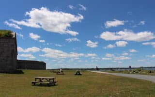
For a longer run, combine Fort Getty with Beavertail State Park. It’s 2.5 miles along Beavertail Rd. — quiet, not that scenic until reaching Beavertail SP — but there are some nice spots at this former coastal defense site, with a lighthouse, great coastal views, and some shoreline trails to explore. ROUTE MAP
Fort Wetherill State Park 10k. From town, we’ve mapped a 10k loop out to Fort Wetherill State Park. Begin by running south along Canonicus Ave., which turns into Wolcott Ave. After 0.8 miles, LEFT on Racquet Rd., for a nice jaunt along the shore, leading into the Park (2-mile mark). A tour of the park’s roads/trails is ~1 mile, with additional options to explore the rocky shore. To make the run a loop, take Fort Wetherill Rd. out of the park and turn LEFT onto Highland Dr. There are a few homes along this road, but not too much else. After 1.5 miles, you’ll reach Hamilton Ave., where we’ve included a quick LEFT to see the views of Sheffield Cove, then the final 1 mile along Southwest Ave., which has a sidewalk, back into town via the windmill at the Jamestown Historical Society. ROUTE MAP
Jamestown, the second largest island in Narragansett Bay, is located 5 miles from Newport using the Claiborne Pell Bridge or from Kingston using Jamestown Bridge. It’s a popular summer colony, home to farms, three state parks, and numerous small beaches. With a population of only 6,000, there’s not a lot of traffic, so running on Jamestown’s roads is generally safe. It’s ~9 miles north-south and ~1 mile east-west. Below are our recommendations on the best places to run in Jamestown, which can be mixed & matched. Notes: Pedestrians aren’t permitted on either of the two bridges to Jamestown.Most of the main roads on Jamestown don’t have a sidewalk/shoulder but there’s generally not too much traffic. Also, there’s a seasonal Ferry from Newport.
Best Run with Ocean Views. The most scenic stretch for running in Jamestown is along Canonicus Ave., near the small historic center on the island’s east side. From the center of town, head south as far as Fort Wetherill Rd. and north to the Jamestown Golf Course. There are great water views, and some gorgeous homes. For a longer run, do a loop around Fort Wetherill State Park, which has great views. In town, it’s enjoy the shops, restaurants, and nice homes along Narragansett Ave., which runs for 1 mile between the east and west sides of the island. It’s also fun to explore some of the quiet residential streets near town. ROUTE MAP
Beavertail State Park. Wikimedia: Leonardo Dasilva
Fort Getty Park & Beavertail State Park. A nice run on generally quiet roads, mixing some historic spots and coastal views. From the parking lot at the park, it’s a ~1 mile tour of the walking paths, with some nice views. Then run out Fort Getty Rd. for a nice stretch along Sheffield Cove. We’ve included a jaunt out to Conanicut Battery Historic Park.
It’s also possible to run to Fort Getty from town — it’s 2 miles, using Narragansett Ave. and the sidewalked Southwest Ave.
For a longer run, combine Fort Getty with Beavertail State Park. It’s 2.5 miles along Beavertail Rd. — quiet, not that scenic until reaching Beavertail SP — but there are some nice spots at this former coastal defense site, with a lighthouse, great coastal views, and some shoreline trails to explore. ROUTE MAP
Fort Wetherill State Park 10k. From town, we’ve mapped a 10k loop out to Fort Wetherill State Park. Begin by running south along Canonicus Ave., which turns into Wolcott Ave. After 0.8 miles, LEFT on Racquet Rd., for a nice jaunt along the shore, leading into the Park (2-mile mark). A tour of the park’s roads/trails is ~1 mile, with additional options to explore the rocky shore. To make the run a loop, take Fort Wetherill Rd. out of the park and turn LEFT onto Highland Dr. There are a few homes along this road, but not too much else. After 1.5 miles, you’ll reach Hamilton Ave., where we’ve included a quick LEFT to see the views of Sheffield Cove, then the final 1 mile along Southwest Ave., which has a sidewalk, back into town via the windmill at the Jamestown Historical Society. ROUTE MAP
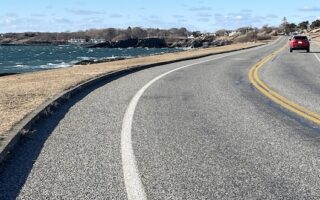
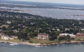
This famous drive is also a spectacular run. This road runs for 4.5 miles between Castle Hill and Bellevue Ave., with great views of Rhode Island Sound and historic coastal homes. Note: Narrow shoulder.
A memorable running experience. Run along this historic, tree-lined street, with views to numerous grand estates. Beautiful landscaping, specimen trees, period lighting. Good options to add w/Cliff Walk, Ocean Ave.
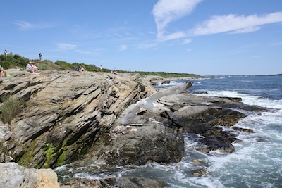
The iconic 3.5 mile Cliff Walk is a 'must do' in Newport. Spectacular views of the ocean & crashing surf on one side, and Newport's gilded age mansions on the other. Most of it is easy-moderate. Go early or off-season to beat the crowds! Famous for daffodils in April!
Combines the scenic Newport waterfront with the Bellevue Ave. mansions and the spectacular Ocean Ave. for a Newport grand tour of 11.6 miles. Good options for longer & shorter. Note: some parts lack sidewalks.
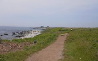
Sachuest Point National Wildlife Refuge is one of the most scenic off-road runs in the Newport area. Great views of dunes and Block Island Sound. A loop is 2.5 miles, with good add-ons. Note this is a popular birding area.
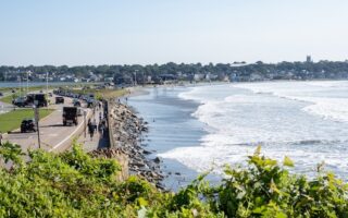
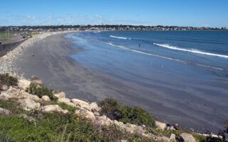
Newport's public beaches -- Easton's (First) Beach, Second Beach, & Third Beach -- are decent for running, generally featuring firm sand. Combine Second and Third Beaches for a great longer beach run! PRO TIP: Daffodils across from Easton's in April!
A nice spot for a standalone run: the loop on mainly waterfront paths and a tour of the fort is 2.5 miles. Great views! For longer, combine with a jaunt over to Castle Hill, or as part of our Newport Grand Tour.
Share your feedback on this route and see that of other Great Runs users. Click on the image icon to upload a photo. And please let us know if there are notes or changes we should incorporate!

Review or Comment on This Route/Share a Photo!
Share your feedback on this route and see that of other Great Runs users. Click on the image icon to upload a photo. And please let us know if there are notes or changes we should incorporate!