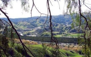
The Riverside/San Bernardino area is surrounded by mountains. There’s some scenic trail running, with options for all abilities, in a series of parks and preserves just east of the city. A few of our favorite spots:
Box Springs Canyon Google Street View
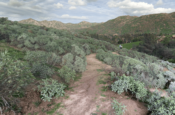
Box Springs Mountain Reserve. This 3,400 acre park located 13 miles east of Riverside has 15 miles of trails overlooking Riverside and the Moreno Valley. The mountain itself rises to 3,000 feet. For scenic and easier trail running options, we recommend driving to the top and running on the two Skyline Loop trails, which are 4.3 miles combined. More challenging trail running involves running to the summit on the M Trail or the Two Trees Trail. TRAIL MAP
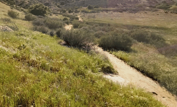
Sycamore Canyon Wilderness Park. Just south of UC Riverside/I-215. 1500-acre park with some lovely trails through the hills. Difficulty is easy to moderate, with some narrower, more rugged trails and some wider dirt roads/fire roads that have easier footing and less of a grade. TRAIL MAP
UC Riverside Campus. The campus of this university sits between Box Springs Mountain and Sycamore Canyon. There are nice pedestrian paths around the main campus, a great running track at the north end of campus, and 2-3 miles trails around the Botanical Gardens and extending south of there as far as the I-215.
The Riverside/San Bernardino area is surrounded by mountains. There’s some scenic trail running, with options for all abilities, in a series of parks and preserves just east of the city. A few of our favorite spots:
Box Springs Canyon Google Street View
Box Springs Mountain Reserve. This 3,400 acre park located 13 miles east of Riverside has 15 miles of trails overlooking Riverside and the Moreno Valley. The mountain itself rises to 3,000 feet. For scenic and easier trail running options, we recommend driving to the top and running on the two Skyline Loop trails, which are 4.3 miles combined. More challenging trail running involves running to the summit on the M Trail or the Two Trees Trail. TRAIL MAP
Sycamore Canyon Wilderness Park. Just south of UC Riverside/I-215. 1500-acre park with some lovely trails through the hills. Difficulty is easy to moderate, with some narrower, more rugged trails and some wider dirt roads/fire roads that have easier footing and less of a grade. TRAIL MAP
UC Riverside Campus. The campus of this university sits between Box Springs Mountain and Sycamore Canyon. There are nice pedestrian paths around the main campus, a great running track at the north end of campus, and 2-3 miles trails around the Botanical Gardens and extending south of there as far as the I-215.
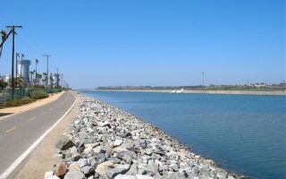
The best option for an easy longer distance off-road run in the Inland Empire. We've mapped the 20 mile section that runs between Riverside and San Bernardino. Some sections with parks and water views, other sections more sprawly & industrial.
A nice run with an optional hill climb in the series of parks just west of downtown. We've put together a 7.5 mile route incorporating Mt. Rubidoux Park, Fairmount Park, and Ryan Bonaminio Park. The Mt. Rubidoux climb is 1.2 miles, 320 foot gain.
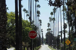
Historic Victoria Ave. is the most scenic on-road running spot in the Riverside area. This divided scenic street is popular for its many trees and exotic plants used to landscape the route. It's up to 7.6 miles. Can do a 'loop' with Gage Canal Trail.
There are some scenic, easier trail running southeast of the San Bernardino in Blair Park, South Hills Preserve, San Timoteo Nature Sanctuary, & Herngt 'Aki' Preserve. Also the Orange Blossom multi-use trail in Redlands.
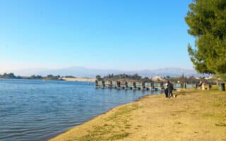
Best running options in the Ontario area are two longer multi-use trails: Pacific Electric Trail, & the Cucamonga Creek Trail. There are also some nice trails around Puddingstone Reservoir/Bonelli Park.
Share your feedback on this route and see that of other Great Runs users. Click on the image icon to upload a photo. And please let us know if there are notes or changes we should incorporate!


Review or Comment on This Route/Share a Photo!
Share your feedback on this route and see that of other Great Runs users. Click on the image icon to upload a photo. And please let us know if there are notes or changes we should incorporate!