
San Juan Island is the gateway to the San Juans, and the most popular island to visit. There are plenty of great options for running on San Juan Island from the trails of the National Historic Park to the quiet roads emanating from Friday Harbor. PARK INFO PARK MAP
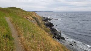 National Historic Park: The San Juan Island National Historic Park is one of the best places to run on San Juan Island. Visitors come for the oceanfront scenery and historic significance, but runners will also find a variety of beautiful grassy paths winding around the bluffs. Most paths are flat and non-technical, so you don’t need to be a serious trail runner to partake in the fun.
There are two main areas to the National Historic Park. American Camp, at the southern tip of San Juan Island, and English Camp on the northwest side of San Juan between Garrison and Wescott bays.
American Camp Area:
Lovely run with great variety: grassland, ocean bluff, water views, and woods. There is a 2.4 mile loop near the American Camp Visitors Center, and a 4.4 mile out and back from Jakle’s Beach Lagoon to the Cattle Point Light. Runners can combine both routes using American Camp Access East for a fun 8.5 mile tour. ROUTE MAP.
English Camp Area:
One of the most popular trails in the English Camp unit is the Bell Point Trail, which winds around the bayside on a mix of smooth, flat gravel and grass tracks. Starting from the main camp area off of West Valley Road, the loop is roughly 2 miles. ROUTE MAP.
 Friday Harbor/Turn Point Loop: Friday Harbor is the ferry port and entryway to San Juan Island. Since most visitors will at least stop through Friday Harbor, it’s the perfect jumping-off place for a run. Good combination of some water views, farmland, and woods. We recommend beginning on Argyle Ave near the center of town. Follow Spring Street toward the ferry terminal, then turn RIGHT onto First Street and bear LEFT onto Warbass Way. After passing the marina, Warbass Way turns into Turn Point Road. There’s not much of a shoulder, but this waterfront way is lightly trafficked and locally popular with walkers, runners, and cyclists. Turn Point Road winds roughly along the shore of Kansas Cove, passing some lovely homes and views. It then turns into Pear Point Road, which meets the south end of Argyle Ave. Turn RIGHT to return to the start. This route is about 6 miles, but some runners add an additional 6 by looping around the San Juan Golf and Tennis Club. Note: There is an outdoor gym at Sunken Park where you can add some strength training to your workout. ROUTE MAP.
Friday Harbor ‘Lab Trail:’ This trail run departs from Friday Harbor and explores some cool coastal forest near the University of Washington marine laboratories. To complete this 7 mile loop, runners can follow Tucker Ave/Roche Harbor Road north from town to the intersection with Sutton Road. Turn RIGHT on Sutton, then RIGHT on Point Caution Drive. The trailhead is on the right near the end of Point Caution Drive. After roughly a mile, it will spit you out on University Road. Turn RIGHT to return to Tucker Ave, then LEFT back to the start. ROUTE MAP.
False Bay Drive: False Bay Drive is another locally treasured road-running route. This lightly trafficked country road on the south end of the island has the best of inland fields and forest, combined with some stunning views along the bay. Runners can stick to False Bay Drive for an out and back of up to 6.8 miles, or combine the road with Bailer Hill Road and Cattle Point Road for a 6.3 mile loop. Caution: Cattle Point Road has a good shoulder, but Bailer Hill Road does not, so approach this stretch with care. ROUTE MAP.
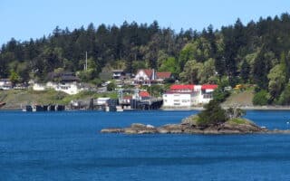
 Roche Harbor Trails: The village of Roche Harbor at the northern reaches of San Juan Island has only a few roads looping through its harborfront restaurants, shops, and resorts, but there is an extensive trail system nearby. Nice mix of water views, farm fields, woods. Runners may enjoy a quick jaunt on the walking path along Reuben Memorial Drive. This connects to the Roche Harbor Road Trail and several other trails to the east. Most of the paths are easy-going grass. Stop by the 20-acre San Juan Island Sculpture Park, then loop around the Roche Harbor Airport Trail and the Rouleau Trail before returning to the start. We’ve mapped a 5.6 mile loop. ROUTE MAP. TRAIL MAP.
Review or Comment on This Route/Share a Photo!
Share your feedback on this route and see that of other Great Runs users. Click on the image icon to upload a photo. And please let us know if there are notes or changes we should incorporate!