San Luis Obispo (SLO) has wonderful trail running options, with something for all abilities within a few miles of town. Here are some highlights.
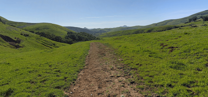
Cal Poly Area. There’s wonderfully hilly and scenic running in the hills behind California Polytechnic State University (“Cal Poly”). Hilly but good footing on generally wide trails. Stenner Creek Trail is popular — trailhead is off Stenner Creek Rd., 3.5 miles from Cal Poly. For a hilly 5k, do the Stenner Creen Trail-Yewks Trail loop. 580 foot gain. For longer, where Stenner Creek Trail intersects with the Yewls Trail, take the Roller Coaster Trail. Many additional trail options. ROUTE MAP
Road Run: 7.5 mile loop combining Stenner Creek Rd. and Poly Canyon Rd. Generally quiet, with great views and access to more roads and mountain trails. From Cal Poly, start on Mt. Bishop Rd. and run for 1 mile to reach Stenner Creek Rd. At 3.4 miles there’s a trailhead for the Stenner Creek Trails. The route has 740 feet elevation gain, but not too steep. Shorter Loop: Via Carta Rd.-Poly Canyon Rd. (3.3 miles, 480 foot gain). ROUTE MAP LONG ROUTE MAP SHORT
Bishops Peak and Felsman Loop. A mile west of Cal Poly, there are wonderful trails around Bishops Peak. The Felsman Loop is a popular trail run, with great views on a wide, rolling hill trail (2.6 miles, 555 foot gain). ROUTE MAP
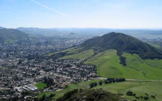
Laguna Lake Open Space. About 2 miles of open trails in the Laguna Lake area, and one of the better options for a flat run. Add on with the trails in the Cerro San Luis Obispo. These are hillier — the Rock Garden Trail is wide and a bit more gradual.
Irish Hills Preserve. 8 miles of trails in a rocky, serpentine landscape containing chaparral, oak, grasslands, and riparian habitats. Popular for mountain biking. Slightly easier running on the double-track trails, and more challenging on the single track. Very hilly — all routes feature significant elevation gain. TRAIL MAP has good suggestions for loops with rating difficulties.
Forest Roads/TVTower Rd. For slightly less challenging trail running, we recommend the forest roads just a few miles north of SLO. From the West Cuesta Ridge Trailhead off Highway 101, a forest road Forest Rte 29S11/TV Tower Rd.) heads northwest for several miles. It’s wide, with gravel and some small rocks, and less hilly than other area mountain trails.
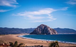
Routzhan Park & Lopez Lake. Located 18 miles southeast of SLO. Several miles of fairly rugged trails. Roller-coaster type trails popular with mountain bikers.
San Luis Obispo (SLO) has wonderful trail running options, with something for all abilities within a few miles of town. Here are some highlights.
Cal Poly Area. There’s wonderfully hilly and scenic running in the hills behind California Polytechnic State University (“Cal Poly”). Hilly but good footing on generally wide trails. Stenner Creek Trail is popular — trailhead is off Stenner Creek Rd., 3.5 miles from Cal Poly. For a hilly 5k, do the Stenner Creen Trail-Yewks Trail loop. 580 foot gain. For longer, where Stenner Creek Trail intersects with the Yewls Trail, take the Roller Coaster Trail. Many additional trail options. ROUTE MAP
Road Run: 7.5 mile loop combining Stenner Creek Rd. and Poly Canyon Rd. Generally quiet, with great views and access to more roads and mountain trails. From Cal Poly, start on Mt. Bishop Rd. and run for 1 mile to reach Stenner Creek Rd. At 3.4 miles there’s a trailhead for the Stenner Creek Trails. The route has 740 feet elevation gain, but not too steep. Shorter Loop: Via Carta Rd.-Poly Canyon Rd. (3.3 miles, 480 foot gain). ROUTE MAP LONG ROUTE MAP SHORT
Bishops Peak and Felsman Loop. A mile west of Cal Poly, there are wonderful trails around Bishops Peak. The Felsman Loop is a popular trail run, with great views on a wide, rolling hill trail (2.6 miles, 555 foot gain). ROUTE MAP
Laguna Lake Open Space. About 2 miles of open trails in the Laguna Lake area, and one of the better options for a flat run. Add on with the trails in the Cerro San Luis Obispo. These are hillier — the Rock Garden Trail is wide and a bit more gradual.
Irish Hills Preserve. 8 miles of trails in a rocky, serpentine landscape containing chaparral, oak, grasslands, and riparian habitats. Popular for mountain biking. Slightly easier running on the double-track trails, and more challenging on the single track. Very hilly — all routes feature significant elevation gain. TRAIL MAP has good suggestions for loops with rating difficulties.
Forest Roads/TVTower Rd. For slightly less challenging trail running, we recommend the forest roads just a few miles north of SLO. From the West Cuesta Ridge Trailhead off Highway 101, a forest road Forest Rte 29S11/TV Tower Rd.) heads northwest for several miles. It’s wide, with gravel and some small rocks, and less hilly than other area mountain trails.
Routzhan Park & Lopez Lake. Located 18 miles southeast of SLO. Several miles of fairly rugged trails. Roller-coaster type trails popular with mountain bikers.

Review or Comment on This Route/Share a Photo!
Share your feedback on this route and see that of other Great Runs users. Click on the image icon to upload a photo. And please let us know if there are notes or changes we should incorporate!