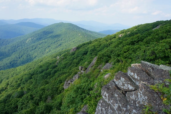
Just 75 miles from Washington, DC, Shenandoah National Park encompasses the Blue Ridge Mountains in Virginia. The park is long and narrow, with the Shenandoah River and valley on the west side, and the piedmont to the east. The Blue Ridge mountains rise to over 4,000 feet.. Gorgeous Skyline Drive, which runs 101 miles, is the principal feature of the park. There are also 500 miles of trails in the park, most of them quite rugged, including 100 miles of the Appalachian Trail. The park has North/Central/South Districts, and the major developed areas are Big Meadows Area, Lewis Mountain, Loft Mountain, Mathews Arm, Elkwallow, and Skyland. Our guide to running in Shenandoah National Park features some of the more ‘runnable’ trails and fire roads. PRO TIP: Famous for mountain laurel & spring wildflowers, May-June.
One can run along Skyline Drive, although there is not much of a shoulder, and the road is very hilly. There are also some gentler hiking/walking trails that make for a great run, including some of the trails in the Big Meadows area, the Snead Farm Loop, and the Limberlost Trail. There are trail markers at all trail heads and intersections. The metal bands are stamped with directional and mileage information.
Note: Bear Alert. For all of these runs, keep in mind that Shenandoah National Park is the home of black bears. It is possible to encounter bears on all of these trails at any time of the day or night. It is not recommended to run alone. If you encounter a bear, stop running immediately. Talk to the bear to make sure it is aware of your presence. Stay more than 50 yards away. If you are closer than 50 yards, back away slowly until there is at least 50 yards between you and the bear. If you need to go past the bear, move slowly around it, keeping 50 yards or more between you and the bear. Do not start running again until you are out of sight of the bear.
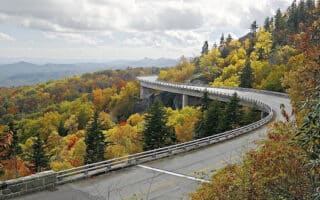
Running on Skyline Drive. Skyline Drive Map
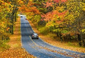 Skyline Drive runs 105 miles through the park. There are some 75 overlooks along Skyline Drive, and mile markers. There are four entrances to Skyline Drive. It is possible to run on Skyline Drive, although we don’t hugely advise it — there is not much of a shoulder along the road and there can be a lot of traffic. There are steep hills and numerous blind curves. Please use caution! Best to go early, wear bright colors and run opposite traffic.
Snead Farm Loop. Mile 5, Skyline Drive. Start: Dickey Ridge Visitor Center. MAP
A 3-mile trail, partly on an old fire road to Snead Barn, can be combined with Fox Hollow Trail. Start on the Dickey Ridge Trail across from the visitor center. At the trailhead, turn right (heading south) and run 0.5 mile to the Fire Road. Turn left on the Fire Road and run 0.5 mile to the Snead Barn. Continue 0.5 mile on the Snead Farm Loop Trail to the intersection with the Dickey Ridge Trail. Turn right (heading north) and run 1.5 miles back to the visitor center.
Skyland Developed Area. Mile 41.7 – 42.5 Skyline Drive. TRAIL MAP
The paved roads through the developed area make a loop that is 1.0 miles in length. There are side roads and trails that cross through the area that can be used to lengthen the run.
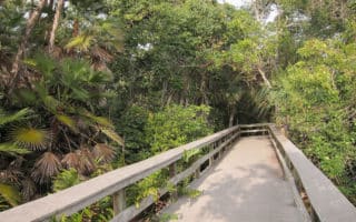
Limberlost Trail. Mile 43, Skyline Drive. 1.3-mile loop.
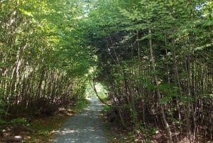 This is a wide, fairly level, handicapped accessible trail that is wheelchair and stroller friendly. The tread of the trail is crushed gravel and is a great surface to run on. The run takes you through the forest and crosses a wooden bridge over a creek and a wooden walkway over a wetland area. It is a loop that can be run several times if you are interested in longer mileages. If you run it both clockwise and counterclockwise you will get a different view of the scenery in each direction.
Big Meadows Developed Area. Mile 51, Skyline Drive. Start at Byrd Visitor Center. Map of Roads and Trails in Area
 This is the most developed area of the park and offers some of the best options for running. There are a couple of options here:
- Big Meadows Lodge/Picnic Area. 4 mile loop. Start at the Byrd Visitor Center and run up the access road to the Big Meadows Lodge along the paved path that is next to the road. Go past the lodge and continue on the road to the Big Meadows Picnic Area. Run on the loop road that goes through the picnic area and then cross over into the Big Meadows Campground. Run on the road that goes around the entire perimeter of the campground and then back down the paved path to Byrd Visitor Center.
- Story of the Forest Trail. 4 mile loop. Start at the visitor center and run up the Story of the Forest Trail to the campground and do the loop in the reverse order – campground, picnic area, lodge and back down the paved path to the visitor center.
- Skyland-Big Meadows Horse Trail. A very pretty horse trail, with yellow blazes. Up to 8 miles, but the first 3 miles are evenly graded and less steep.
Rapidan Fire Road. Mile 51.3 of Skyline Drive
This is a gentler gravel road for running. A good section is 3 miles one-way from the Byrd Visitor Center to the intersection with the Stony Mountain Trail. There is a 500 foot drop in elevation from Big Meadows to the Stony Mountain Trail.
- 3.0 mile out and back: Start at Skyline Drive and run 1.5 miles out the Rapidan Fire Road until the road begins to go downhill. Turn around at this point and run back. The first 1.5 miles is a fairly level gravel road that passes across the wide open Big Meadow before entering the forest.
- 12.0 miles round trip: After 1.5 miles, the road begins to go downhill where it descends for another 4.5 miles to the bottom of the mountain with a 1100 foot elevation change. At the bottom, you can either turn right and run 0.5 miles to Rapidan Camp to Rapidan Camp (President Hoover’s summer fishing retreat) or turn left and run 0.25 miles to the park boundary where there is a gate. The road continues outside of the park.
Blue Ridge Tunnel Trail. South End of Skyline Drive.
At the South Terminus of the Skyline Drive Scenic Roadway, The Blue Ridge Tunnel Trail is great off-road running option through the Shenandoah Valley, with plenty of scenic views. It’s 2.25 miles one-way, with a crushed stone surface. The highlight is the tunnel itself, which is a roughly 5-10 minute run. Locals recommend that runners travel with a light for safety. ROUTE MAP.
Fire/Service Roads
There are many fire and service Roads in the park that would make good running trails. Consult with a Park Ranger at one of the Visitor Centers.
At the south end of Skyline Drive at I-64 is the north entrance of the Blue Ridge Parkway. See our guide to the best running options there!
Appalachian Trail
The AT parallels Skyline Drive for much of the park. There are many access points to the Appalachian Trail at overlooks or where it crosses Skyline Drive. It’s possible to run on the AT, although it’s more for trail running and naturally it is narrow with rough terrain and challenging footing.


Review or Comment on This Route/Share a Photo!
Share your feedback on this route and see that of other Great Runs users. Click on the image icon to upload a photo. And please let us know if there are notes or changes we should incorporate!