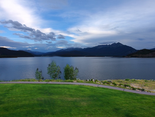
There’s a series of trails around and near the Dillon Reservoir that are good for running. These mainly paved multi-use trails feature great views of the lake and the Ten Mile & Gore Mountain ranges.
It’s possible to run around the entire reservoir, but there are some sections that are on-road, very hilly, and not right along the water. We’ve put together two routes focused on the most scenic sections along the east and west sides of the reservoir that can be mixed and matched. The start point is at the Dillon Marina, but there are options to access the trails from other points.
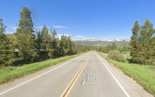
Reservoir West Side: Dillon Marina to Frisco. 6.7 miles. This paved path runs along the west side of the Dillon Reservoir between Dillon Marina and Frisco. It’s mainly referred to as the Dillon Dam Rec Path. The first 2.5 miles, along the marina and then on a waterside path along Dillon Dam Rd. are particularly scenic, with great water and mountain views. The trail then turns inland, through a combination of some open and forested terrain. The trail can be accessed from the Dillon Marina, Silverthorne (via a 1-mile connector trail from the Silverthorne Outlets), or from Frisco.
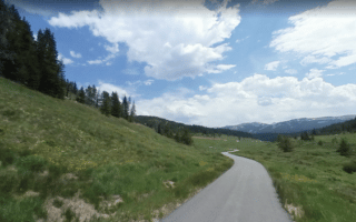
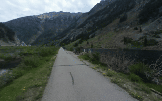
Reservoir East Side: Dillon Marina to Montezuma/Keystone 3.7 miles. This paved multi-use trail, called the Snake River Rec Path, runs along the east side of the Reservoir toward Keystone. The first 2.5 miles, which run right along Dillon Bay, are particularly scenic, with great water and mountain views. Then the path turns inland to Swan Mountain Rd. in Montezuma.
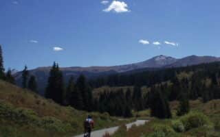
- Add-Ons. Take the Swan River Rec Paths for another 2.5 fairly flat miles to the Sapphire Point Overlook. Or, the Snake River Rec Path continues east as the Montezuma Spur Recpath toward the Keysone ski area.
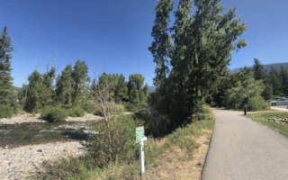
Frisco Peninsula Recreation Area. For an easy-ish trail run, we recommend the Frisco Peninsula Recreation Area, which is near downtown Frisco and bisects Frisco Bay and Blue River Arm. Park at the Dickey Day Use Area and run along the interior trail or along the shore of Lake Dillon. Nice water & mountain views! It’s ~2 miles out to the end of the peninsula.
There’s a series of trails around and near the Dillon Reservoir that are good for running. These mainly paved multi-use trails feature great views of the lake and the Ten Mile & Gore Mountain ranges.
It’s possible to run around the entire reservoir, but there are some sections that are on-road, very hilly, and not right along the water. We’ve put together two routes focused on the most scenic sections along the east and west sides of the reservoir that can be mixed and matched. The start point is at the Dillon Marina, but there are options to access the trails from other points.
Reservoir West Side: Dillon Marina to Frisco. 6.7 miles. This paved path runs along the west side of the Dillon Reservoir between Dillon Marina and Frisco. It’s mainly referred to as the Dillon Dam Rec Path. The first 2.5 miles, along the marina and then on a waterside path along Dillon Dam Rd. are particularly scenic, with great water and mountain views. The trail then turns inland, through a combination of some open and forested terrain. The trail can be accessed from the Dillon Marina, Silverthorne (via a 1-mile connector trail from the Silverthorne Outlets), or from Frisco.
Reservoir East Side: Dillon Marina to Montezuma/Keystone 3.7 miles. This paved multi-use trail, called the Snake River Rec Path, runs along the east side of the Reservoir toward Keystone. The first 2.5 miles, which run right along Dillon Bay, are particularly scenic, with great water and mountain views. Then the path turns inland to Swan Mountain Rd. in Montezuma.
- Add-Ons. Take the Swan River Rec Paths for another 2.5 fairly flat miles to the Sapphire Point Overlook. Or, the Snake River Rec Path continues east as the Montezuma Spur Recpath toward the Keysone ski area.
Frisco Peninsula Recreation Area. For an easy-ish trail run, we recommend the Frisco Peninsula Recreation Area, which is near downtown Frisco and bisects Frisco Bay and Blue River Arm. Park at the Dickey Day Use Area and run along the interior trail or along the shore of Lake Dillon. Nice water & mountain views! It’s ~2 miles out to the end of the peninsula.


Review or Comment on This Route/Share a Photo!
Share your feedback on this route and see that of other Great Runs users. Click on the image icon to upload a photo. And please let us know if there are notes or changes we should incorporate!