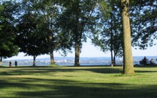
This is a pleasant run in the Southside and Strathmore neighorhoods south of downtown, featuring Onondaga Park, two small reservoir loops, and pleasant residential streets. Start in Onandaga Park, an older style park with landscaped grounds, and numerous recreation facilities. It’s a 100-foot hilly climb to the gazebo and short loop around Hiawatha Lake. Exit the park at the tennis courts and use Summit Ave., heading south to Elmwood Park, enjoying leafy little loop down to Furnace Brook. Next, run some of the nice residential streets of the Southside/Strathmore neighborhoods, which feature tree-lined streets and older homes. Head west on Charmouth Dr., RIGHT on Robineau, then BEAR LEFT on Twin Hills Dr., then the scenic 1-mile loop around Woodland Reservoir. Return to Onandaga Park heading east on Crossett St.

Creative Commons License
Scroll Down For Route Maps
Essentials
- 5.1 miles (8.2 km)
- 440m (140 feet)
- Onondaga Park
- Onondaga Park is ~2 miles south of downtown
Current Weather & Forecast

Syracuse, IT
6:32 am,
Jul 14, 2026
L: 28°
H: 28°
Daily ForecastHourly Forecast
Today
11:00 pm
18° / 33°°C
0 mm
0%
13 mph
54 %
1021 mb
0 mm/h
Tomorrow
11:00 pm
18° / 33°°C
0 mm
0%
16 mph
55 %
1019 mb
0 mm/h
Thursday
11:00 pm
14° / 31°°C
1 mm
100%
11 mph
84 %
1018 mb
0 mm/h
Friday
11:00 pm
13° / 34°°C
0.98 mm
98%
6 mph
79 %
1019 mb
0 mm/h
Saturday
11:00 pm
14° / 33°°C
0 mm
0%
11 mph
66 %
1019 mb
0 mm/h
Today
8:00 am
21° / 23°°C
0 mm
0%
6 mph
42 %
1020 mb
0 mm/h
Today
11:00 am
20° / 20°°C
0 mm
0%
7 mph
46 %
1020 mb
0 mm/h
Today
2:00 pm
18° / 19°°C
0 mm
0%
6 mph
54 %
1021 mb
0 mm/h
Today
5:00 pm
24° / 24°°C
0 mm
0%
3 mph
27 %
1017 mb
0 mm/h
Today
8:00 pm
31° / 31°°C
0 mm
0%
5 mph
14 %
1012 mb
0 mm/h
Today
11:00 pm
33° / 33°°C
0 mm
0%
13 mph
12 %
1009 mb
0 mm/h
Tomorrow
2:00 am
29° / 29°°C
0 mm
0%
16 mph
24 %
1011 mb
0 mm/h
Other Routes in Syracuse, NY
One of the signature runs in Syracuse. Restoration Way is a multi-use path that runs for nearly 8 miles along the eastern and western sides of the lake, with water and city views, and numerous parks.
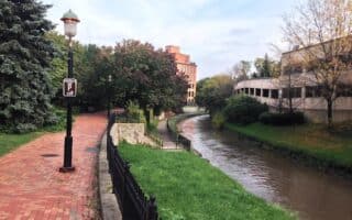
This route incorporates the central section of Syracuse downtown with the pleasant creekside trail that runs along Onondaga Creek and the Inner Harbor, ending at Onondaga Lake. For a longer run, combine with our University route.
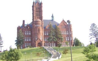
This route is one of our favorites in Syracuse, combining Thornden Park, the attractive campus of Syracuse University, historic Oakwood Cemetery, and the bucolic Eastside neighborhood. Use our 6.8 mile route or create your own!
Many miles of scenic running on the Erie Canal Towpath in the Syracuse area. We've mapped a 10.6 mile eastern section from Dewitt to Chittenango Landing, combination paved and stone dust. Green Lakes State Park is good add-on.
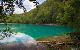
Great spot for some gentle trail running, located 10 miles east of downtown. There are 15+ miles of trails through woods and around two glacial lakes. Can combine with a section of the Erie Canal Towpath.
Runners can enjoy many miles of the Erie Canal Towpath in the Syracuse area. We've mapped a 12-mile western section from Camillus to Jordan on a stone dust surface. The path continues a further 8 miles west to Port Byron, then is on-road.
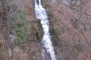
Park located 15 miles south of Syracuse is known for its 137-foot waterfall and is a good spot for trail running. The two main trails are the 2.6 mile North Rim Trail and the 1.2 mile West Branch Trail.
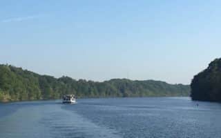
Beaver Lake Nature Center, located 15 miles northwest of Syracuse, is a worth-it destination run. There are 9 miles of trails around the 200-acre glacial lake, featuring a lovely combination of woods, meadows, and lake views.
User Ratings
Leave A Review or Comment
Review or Comment on This Route/Share a Photo!
Share your feedback on this route and see that of other Great Runs users. Click on the image icon to upload a photo. And please let us know if there are notes or changes we should incorporate!