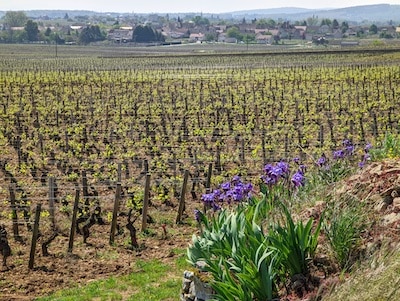
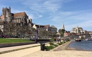
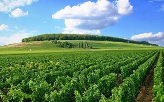
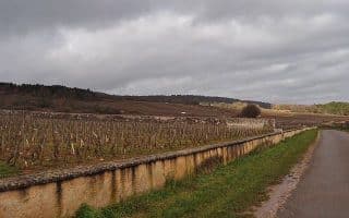
Among the huge network of multi-use paths in Burgundy, the Veloroute La Voie des Vignes is among our favorite. This multi-use path “of the Vineyards” is a ~35 km cycle route through the region’s winemaking history that’s also terrific for running. It’s a very popular recreation destination in the region. The mainly paved path follows back roads and vineyard paths from Beaune west to Nolay. Highlights along this former railway line include numerous chateaus, chapels, and cafes of quaint wine villages, cliffside vistas, and viaducts.
The route has gentle grades for the first 22 km. From Santenay to Nolay (kms 23-35) headed northwest, there is more climbing.
Mark Miller
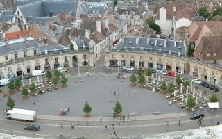
Distances: Beaune makes for a good central starting point, and is a beautiful town with nice running of its own. From Beaune, it’s about 5.5 km to Volnay, 8.5 km to Meursault, 12.8 km to Puligny-Montrachet, 15 km to Chassagne-Montrachet, 21.6 km to Santenay, 27.2 km to Paris L’Hopital, 31.5 km to Nolay, and 36.2 km to the end of the path. ROUTE MAP.
Add-Ons: See our running tour of Beaune. Also, at the medieval village of Nolay, runners and cyclists can connect to the Canal du Centre. See also our list of other multi-use paths in Burgundy.
Among the huge network of multi-use paths in Burgundy, the Veloroute La Voie des Vignes is among our favorite. This multi-use path “of the Vineyards” is a ~35 km cycle route through the region’s winemaking history that’s also terrific for running. It’s a very popular recreation destination in the region. The mainly paved path follows back roads and vineyard paths from Beaune west to Nolay. Highlights along this former railway line include numerous chateaus, chapels, and cafes of quaint wine villages, cliffside vistas, and viaducts.
The route has gentle grades for the first 22 km. From Santenay to Nolay (kms 23-35) headed northwest, there is more climbing.
Mark Miller
Distances: Beaune makes for a good central starting point, and is a beautiful town with nice running of its own. From Beaune, it’s about 5.5 km to Volnay, 8.5 km to Meursault, 12.8 km to Puligny-Montrachet, 15 km to Chassagne-Montrachet, 21.6 km to Santenay, 27.2 km to Paris L’Hopital, 31.5 km to Nolay, and 36.2 km to the end of the path. ROUTE MAP.
Add-Ons: See our running tour of Beaune. Also, at the medieval village of Nolay, runners and cyclists can connect to the Canal du Centre. See also our list of other multi-use paths in Burgundy.
Scroll Down For Route Maps
Essentials
Up to 35 km (22 miles) one-way
406m (1332 feet). Most of the elevation is from km 22-35
Beaune is a great hub for exploring the area's wineries and vineyards. Explore the town on this 'runseeing' tour around the old city walls and the Park Bouzaize. Add on with the narrow streets of the largely pedestrianized historic center and the Vineyard Cycle Path.
The Tour de Bourgogne à Vélo is a vast network of long-distance, multi-use paths along Burgundy's rivers and canals. We've mapped six of these paths across the region, which can be used as a great resource for a run in the area!
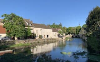
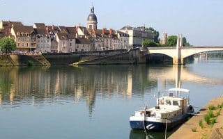
The commune of Chalon Sur Saône rests on the banks of the Saône River, where a number of waterfront paths and picturesque bridges create plenty of opportunities for running.
See our separate guide for running in Dijon, the capital of Burgundy. Best options are Lac Kir, paths along the L'Ouche River and canals, our 'runseeing' tour, and Colombière Park, with its grand allée paths.
The team at Beaune Tourism highly recommends this quiet, scenic road running option about 20 km west of Beaune. The “Roman Road” through the Cossane Valley features an ivy-covered aqueduct, riverbanks, and a scenic plateau.
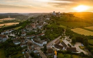
The wine village of Pernand-Vergelesses is dotted with classic French architecture, vineyards, and carefully crafted monuments, all of which can be explored on this ~6 km loop around Corton Hill.
Puligny-Montracet and Chassagne-Montracet together make up a famous wine region, and runners will find a delightful 8 km route through the vineyards here.
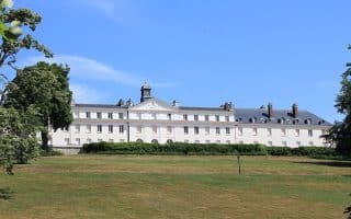
The stunning Chateau and its grounds date back to the 15th century. A loop around the building and lakes is only about 3 km, but it’s a gorgeous spot to run some laps.
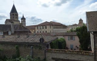
Runners can catch glimpses of the Abbey by doing a 3 km tour of the city walls. Also, good running on the Vois Verte, a lovely multi-use path passing through Cluny in its 70 km between Chalon-sur-Saône and Mâcon.
Run through this beautiful regional park on a section of its two long distance walking routes: the GR 13 or the Tour du Morvan. Alternates between quiet dirt carriage roads and the sidewalks of main streets.
Share your feedback on this route and see that of other Great Runs users. Click on the image icon to upload a photo. And please let us know if there are notes or changes we should incorporate!
Subscribe
0 Comments
Oldest
Newest
Inline Feedbacks
View all comments
Essentials
Up to 35 km (22 miles) one-way
406m (1332 feet). Most of the elevation is from km 22-35

Review or Comment on This Route/Share a Photo!
Share your feedback on this route and see that of other Great Runs users. Click on the image icon to upload a photo. And please let us know if there are notes or changes we should incorporate!