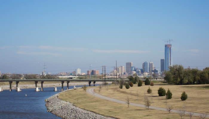
There are 17.5 miles of paved trails along the Oklahoma River and the North Canadian River, with paths along both banks in section. Most of the trails are quite open, with good water views. Overall, it’s 17.5 miles of riverfront trails between Eagle Lake and Lake Overholser. A few recommendations & options:
Full Trail: The section from Eagle Lake to Pace’s Point is 11.7 miles, and then it’s 5.8 miles on the West River Trail to Crystal Lake and along the North Canadian River to Lake Overholser. MAP
North Bank: Good access from downtown, at Regatta Park. Run up to 5 miles west to South Portland Ave. MAP
Loop Option: Not all of the bridges crossing the river are runnable — some are quite busy highways — but runners can string together a 9.5 mile loop using the Portland and Robinson bridges. MAP.
First Nations Museum & Eagle Lake Loop. The newly opened First Americans Museum, located on the south bank of the river, is a major visitor destination in Oklahoma City. There’s a 4.3 mile route on the Eagle Lake Trail from there that includes a 1.3 mile loop around Eagle Lake. Run separately or as part of the longer River Trail. MAP
Not sure where to start? There are parking areas at the Oklahoma Boathouse, Wheeler Park, Wiley Post Park, the Mat Hoffman Action Sports Complex, the Exchange Ave Bridge, Lincoln Ave Bridge, and SW 15 and Portland.
Ancillary Trails:
The Oklahoma River Trails make for a wonderful long run, but they aren’t the only multi-use trails in Oklahoma City. These three paths, which easily connect to the River Trails and other networks, are important supplements to the Oklahoma City trail system.
Lake Overholser. From the north end of the West River Trail, see our route along Lake Overholser, with an option to exend to Lake Hefner.
South Grand Trail: Though perhaps not the most scenic route in Oklahoma City, the South Grand Trail is a 10 mile path starting from the Oklahoma River Trail and heading south to Industrial Heights. From here, it bends west and runs along SW36th street to Trosper Park. The trail then bends north along East Grand Boulevard back to the river. MAP.
Will Rogers Trail: Another new multi-use path stemming from the Oklahoma River Trail, the Will Rogers Trail is a a long off street pathway paralleling busy streets north to Lake Hefner. MAP.
Katy Trail: The Katy Trail sets out from Washington Park, just northwest from the Oklahoma River and the Bricktown neighborhood. This 6 mile multi-use path travels along a dedicated space on the path of the former Katy Railroad, though some sections utilize on-street bike lanes. MAP.


Review or Comment on This Route/Share a Photo!
Share your feedback on this route and see that of other Great Runs users. Click on the image icon to upload a photo. And please let us know if there are notes or changes we should incorporate!