We’ve put together two different ‘runseeing’ tours of Reims, featuring a lot of elements: historic sites, several lovely parks, and a nice section along the water. Our thanks for Mark Miller for his Reims highlights tour!
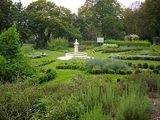
Parc de Champagne. Creative Commons
Option 1:This route starts in the historic center and includes Parc Champagne. Start at the impressive Hôtel de ville (city hall), and take Rue de Mars north to Les Hautes Promenades. Head south on the paths through this park, passing Square Colbert, and into the Parc de la Patte d’Oie, which dates back to 1733. Cross over the river at the Pont de Vesle, and head south on the multi-use path along the water for 3 km. Cross back over the water on Rue des Essillards, and head inland to the Parc de Champagne, a lovely city park that also has a small botanic garden. Exit the north end of the park into Av. du Général Giraud for 0.7 km to the Place des Droits de l’Homme rotary, and then run through the Parc de la Butte Saint-Nicaise, exiting at the Rue du Réservoir, heading east to the famous Tattinger House, which dates back to the Roman era. Take Rue du Barbâtre, a main commercial street, for ~1.5 km back toward the Reims historic center, ending at the Palais du Tau and the iconic Cathédrale Notre-Dame de Reims. Shorter Option: You can shorten the route by ~2 km by eliminating the Parc de Champagne section, using the D8 road for a more direct connection to the Place des Droits de l’Homme.
Option 2: Designed and run by Mark Miller. Starts on the river path, eliminating Parc de Champagne, but adding Parc Léo Lagrange and the Cimetière du Nord.
Mark Miller
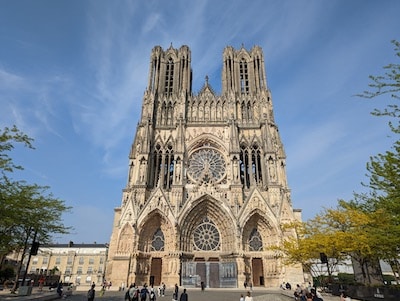
Start on the La Vesle River/canal near Pont de Vesle (bridge) and run south along the water for 0.5 km. Use Av. Paul Marchandeau to cross over to Parc Léo Lagrange, a pleasantly wooded park with a small pond. Exit the northern end and use Pont de la Vesle (bridge) to cross back over, getting onto the linear park path for 2 km through Square de la Patte d’Oie, Les Hautes Promenades, and the runnable Cimetière du Nord. The next 2.5 km hits some of the key historic sites of Reims, including City Hall (Hôtel de ville), Musée-Hôtel Le Vergeur/Place Royal, and the spectacular Cathédrale Notre-Dame de Reims.
Mark Miller
For a 9k run, end the route back at the starting point. The mapped route adds another 2.5 km along the river, which can be extended further along the Canal de la Marne à l’Aisne path, which goes for ~7 km from Reims to Saint-Léonard.
Longer Option: Additional paths along the river/canal. Can also include Parc Champagne (see Option 1).
We’ve put together two different ‘runseeing’ tours of Reims, featuring a lot of elements: historic sites, several lovely parks, and a nice section along the water. Our thanks for Mark Miller for his Reims highlights tour!
Parc de Champagne. Creative Commons
Option 1:This route starts in the historic center and includes Parc Champagne. Start at the impressive Hôtel de ville (city hall), and take Rue de Mars north to Les Hautes Promenades. Head south on the paths through this park, passing Square Colbert, and into the Parc de la Patte d’Oie, which dates back to 1733. Cross over the river at the Pont de Vesle, and head south on the multi-use path along the water for 3 km. Cross back over the water on Rue des Essillards, and head inland to the Parc de Champagne, a lovely city park that also has a small botanic garden. Exit the north end of the park into Av. du Général Giraud for 0.7 km to the Place des Droits de l’Homme rotary, and then run through the Parc de la Butte Saint-Nicaise, exiting at the Rue du Réservoir, heading east to the famous Tattinger House, which dates back to the Roman era. Take Rue du Barbâtre, a main commercial street, for ~1.5 km back toward the Reims historic center, ending at the Palais du Tau and the iconic Cathédrale Notre-Dame de Reims. Shorter Option: You can shorten the route by ~2 km by eliminating the Parc de Champagne section, using the D8 road for a more direct connection to the Place des Droits de l’Homme.
Option 2: Designed and run by Mark Miller. Starts on the river path, eliminating Parc de Champagne, but adding Parc Léo Lagrange and the Cimetière du Nord.
Mark Miller
Start on the La Vesle River/canal near Pont de Vesle (bridge) and run south along the water for 0.5 km. Use Av. Paul Marchandeau to cross over to Parc Léo Lagrange, a pleasantly wooded park with a small pond. Exit the northern end and use Pont de la Vesle (bridge) to cross back over, getting onto the linear park path for 2 km through Square de la Patte d’Oie, Les Hautes Promenades, and the runnable Cimetière du Nord. The next 2.5 km hits some of the key historic sites of Reims, including City Hall (Hôtel de ville), Musée-Hôtel Le Vergeur/Place Royal, and the spectacular Cathédrale Notre-Dame de Reims.
Mark Miller
For a 9k run, end the route back at the starting point. The mapped route adds another 2.5 km along the river, which can be extended further along the Canal de la Marne à l’Aisne path, which goes for ~7 km from Reims to Saint-Léonard.
Longer Option: Additional paths along the river/canal. Can also include Parc Champagne (see Option 1).
Scroll Down For Route Maps
Essentials
Option 1: 10.2 km (6.4 miles); Option 2: 11.3 km (7 miles). Both runs can be shortened or lengthened
66m (216 feet)
Option 1: Hôtel de ville (city hall)l; Option 2: River Path near Pont de Vesle
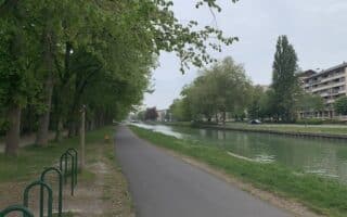
One of the centerpieces of running in Reims is the path along the Canal de la Marne à l'Aisne. Called the All. de Tilleuls, the multi-use path runs for up to 7 km along the south bank of the Canal. Nice water views!
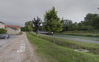
Head 11 km north of Reims to enjoy a paved bike path along the narrow La Loivre river. It's a nice 9.3 km out and back, with nice views of the narrow river and surrounding countryside.
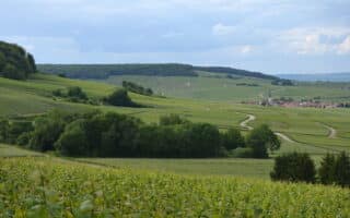
120,000 acre regional park just south of Reims has 300+ km of paths and trails that are wonderful for running. Terrain ranges from forest paths to rolling hills trails through vineyards. There are dozens of waymarked routes of varying lengths and levels of ability.
Share your feedback on this route and see that of other Great Runs users. Click on the image icon to upload a photo. And please let us know if there are notes or changes we should incorporate!
Subscribe
0 Comments
Oldest
Newest
Inline Feedbacks
View all comments
Essentials
Option 1: 10.2 km (6.4 miles); Option 2: 11.3 km (7 miles). Both runs can be shortened or lengthened
66m (216 feet)
Option 1: Hôtel de ville (city hall)l; Option 2: River Path near Pont de Vesle

Review or Comment on This Route/Share a Photo!
Share your feedback on this route and see that of other Great Runs users. Click on the image icon to upload a photo. And please let us know if there are notes or changes we should incorporate!