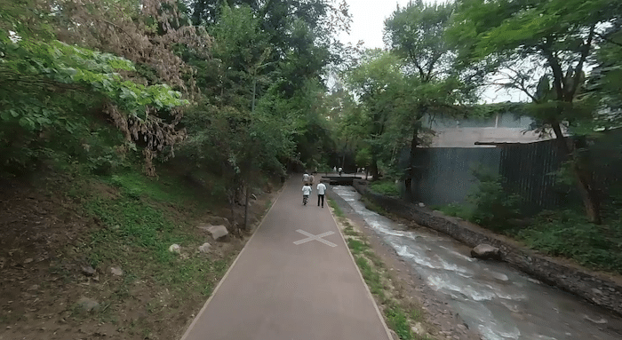
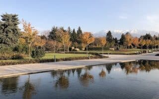
The Терренкур Terrenkur path is one of the better opportunities for a dedicated off-road path in Almaty. The paved multi-use path runs south from KIMEP University (Abay Ave.) for 5 km to the Terrenkur Pond Pavilion. It’s a mix of residential areas, some small parks, and some wooded sections. In parts, the path follows a small river. Note: it’s a steady climb headed south, nearly 200m gain!
Longer Option: From the north end of the Терренкур Terrenkur at Abay Ave., continue north on a path alongside the Kazachka River. There’s a nice 2 km section to Central Park, and another 2 km possible north of there. ROUTE
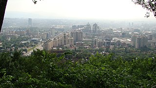
View from Kok Tobe Hill. CC: Алексей Тараканов
Kok Tobe Hill. For a fun & scenic challenge, run/walk to the summit of Kok Tobe Hill. There’s a road that leads from the Visit Almaty Tourist information center in Kok-Tobe up the hill, and it’s much used by pedestrians. It’s 0.6 km east of the Терренкур Terrenkur path at Zhamal Omarova St. Then it’s a 1.3 km to the summit, climbing ~120m. There are great views from the summit. From the summit, there are some other roads and paths.
One can combine the Терренкур Terrenkur & Kok Tobe Hill paths, even using the cable car either up or down. The cable car runs from Abay Ave.
The Терренкур Terrenkur path is one of the better opportunities for a dedicated off-road path in Almaty. The paved multi-use path runs south from KIMEP University (Abay Ave.) for 5 km to the Terrenkur Pond Pavilion. It’s a mix of residential areas, some small parks, and some wooded sections. In parts, the path follows a small river. Note: it’s a steady climb headed south, nearly 200m gain!
Longer Option: From the north end of the Терренкур Terrenkur at Abay Ave., continue north on a path alongside the Kazachka River. There’s a nice 2 km section to Central Park, and another 2 km possible north of there. ROUTE
View from Kok Tobe Hill. CC: Алексей Тараканов
Kok Tobe Hill. For a fun & scenic challenge, run/walk to the summit of Kok Tobe Hill. There’s a road that leads from the Visit Almaty Tourist information center in Kok-Tobe up the hill, and it’s much used by pedestrians. It’s 0.6 km east of the Терренкур Terrenkur path at Zhamal Omarova St. Then it’s a 1.3 km to the summit, climbing ~120m. There are great views from the summit. From the summit, there are some other roads and paths.
One can combine the Терренкур Terrenkur & Kok Tobe Hill paths, even using the cable car either up or down. The cable car runs from Abay Ave.
Scroll Down For Route Maps
Essentials
Терренкур Terrenkur path: up to 5 km one-way; Kok Tobe Hill: 1.6 km (1 mile) one-way. Add 0.6 km if accessing from Терренкур Terrenkur path
Терренкур Terrenkur path is a 200m (198 feet) gain headed north-south; Kok Tobe Hill is a 120m (390 feet) gain
North end of Терренкур Terrenkur path is Abay Ave. Kok Tobe Hill road is from the Visit Almaty Tourist information center in Kok-Tobe
Subway: Abay Ave. For Kok Tobe, road starts at Visit Almaty Tourist information center in Kok-Tobe, or from the Терренкур Terrenkur path (0.6 km to the Kok Tobe road)
This 10k 'runseeing' tour of Almaty includes Republic Square/Park of the First President, Park of 28 Panfilov Guardsmen, Astana Square, Zenkov Cathedral, & the main commercial streets. Nearly all off-road or on pleasant promenades.
One can do a nice 4-5 km run on paths in newly renovated Central Park, a recreational hub located 1 km east of Republic Square. There's also ~4 km of roads/paths along the adjacent Kazachka River, which can be run separately or combined.
Some nice running in central Almaty. 2-3 km of scenic paths in the Botanical Garden. Ghandi Park is a strip of green with a 1.7 km path running through it. Can combine for a 14 km run, including South Park.
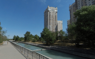
A 3.7 km loop around this reservoir, located between Abay Ave. & Tole Bi St., near the Tastak historic district. There are paths along both sides, and observation decks.
This 7.5 km tour of First President Park and the Big Almaty Riverbank Path is the best opportunity for an all off-road run in Almaty. It's located in the Bostandyk District just south of the centre.
Share your feedback on this route and see that of other Great Runs users. Click on the image icon to upload a photo. And please let us know if there are notes or changes we should incorporate!
Subscribe
0 Comments
Oldest
Newest
Inline Feedbacks
View all comments
Essentials
Терренкур Terrenkur path: up to 5 km one-way; Kok Tobe Hill: 1.6 km (1 mile) one-way. Add 0.6 km if accessing from Терренкур Terrenkur path
Терренкур Terrenkur path is a 200m (198 feet) gain headed north-south; Kok Tobe Hill is a 120m (390 feet) gain
North end of Терренкур Terrenkur path is Abay Ave. Kok Tobe Hill road is from the Visit Almaty Tourist information center in Kok-Tobe
Subway: Abay Ave. For Kok Tobe, road starts at Visit Almaty Tourist information center in Kok-Tobe, or from the Терренкур Terrenkur path (0.6 km to the Kok Tobe road)

Review or Comment on This Route/Share a Photo!
Share your feedback on this route and see that of other Great Runs users. Click on the image icon to upload a photo. And please let us know if there are notes or changes we should incorporate!