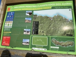
Terceira has a wonderful network of walking and hiking trails. They’re very well marked: there’s always a kiosk with a map at the trailhead (take a picture of it), with good information on distance, level of difficulty, and key directions. The trails themselves also have good signage. We’ve found that the trails marked ‘easy’ are the best for running. Generally they’re not too hilly and have a good surface. Those marked as ‘medium’ or ‘difficult’ are more challenging, technical trail running. A few favorites are below. Click on links for more information, including maps, gpx files, & leaflets.
Typical Trail Kiosk
Fortes de São Sebastião. 5.7 km one-way. Located in the volcanic massif of Cinco Picos, this route travels along the Southeast coast of the island, passing by remains of ancient maritime defensive forts and ending in the village of São Sebastião.
Relheiras de São Brás. 5 km loop. Nice shaded loop trail with some heathers and Japanese cedars.
Typical trail marker
Terceira has a wonderful network of walking and hiking trails. They’re very well marked: there’s always a kiosk with a map at the trailhead (take a picture of it), with good information on distance, level of difficulty, and key directions. The trails themselves also have good signage. We’ve found that the trails marked ‘easy’ are the best for running. Generally they’re not too hilly and have a good surface. Those marked as ‘medium’ or ‘difficult’ are more challenging, technical trail running. A few favorites are below. Click on links for more information, including maps, gpx files, & leaflets.
Typical Trail Kiosk
Fortes de São Sebastião. 5.7 km one-way. Located in the volcanic massif of Cinco Picos, this route travels along the Southeast coast of the island, passing by remains of ancient maritime defensive forts and ending in the village of São Sebastião.
Relheiras de São Brás. 5 km loop. Nice shaded loop trail with some heathers and Japanese cedars.
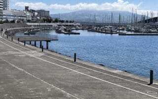
A pleasant waterfront run in Ponta Delgada -- capital of the Azores and its largest city. It's one of the few opportunities on São Miguel for a flat, easy run along the water. 10k out and back, and great views!
Easy trail run along a path above the water on the northern coast of São Miguel, between Calhetas and São Vicente Ferreira. Fantastic views the whole way. Path is more of a wide dirt road. Up to 6.5 km one-way.
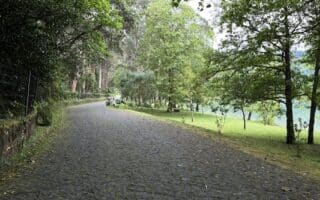
Easy and scenic 6 km loop on a path around this popular lake. Great views of the lake, surrounding mountains, and lovely trees and flowers. There are hot springs at the lake's southern end. Also possible to run from Furnas (hilly!).
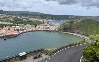
We've scoped out the best options for safe and scenic waterfront running on the island of Terceira. Includes routes in Angra do Heroísmo, Negrito, the area around Fort of Greta, Biscoitos, and Praia da Vitória.
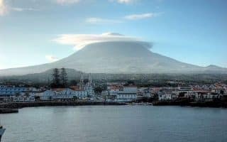
Our guide to running on some 30 km of quiet, scenic coastal roads on Pico, including a 13 km cycle path between Madalena and Arcos. Great views of the water and the island's unique landscape: Mt. Pico, farms, vineyards, & lava fields.
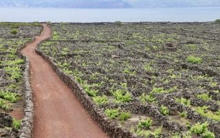
Our recommendations for some of the walking/hiking trails on Pico that are an easy-to-moderate trail run. Lava fields, vineyards, coastal views. Vinhas da Criação Velha is a favorite. Also we point out some of the scenic, quiet interior roads.
We've scoped out some scenic, (relatively) flat waterfront routes on São Jorge island: Velas (including two running tracks!), Calheta, & Urzelina. Trail runners looking for scenery & hills will be in heaven!
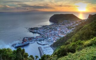
A small, scenic, and hilly island! The best, easy waterfront run is in the city of Horta, location of the ferry terminal. Get the heart rate up by adding the road up Monte Guia!
Share your feedback on this route and see that of other Great Runs users. Click on the image icon to upload a photo. And please let us know if there are notes or changes we should incorporate!


Review or Comment on This Route/Share a Photo!
Share your feedback on this route and see that of other Great Runs users. Click on the image icon to upload a photo. And please let us know if there are notes or changes we should incorporate!