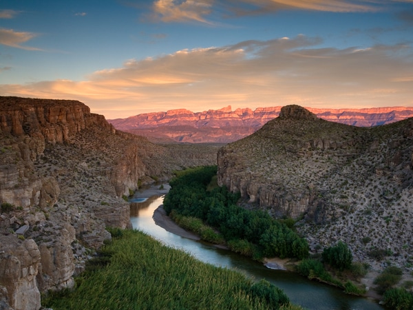
BIG BEND NATIONAL PARK, TX - DECEMBER 8, 2007: View of the Rio Grande River from the cliffs along the hot springs trail to Rio Grande Village. The Rio Grande is a natural border seperating Mexico (on the right) from the United States (left). In the distance the Sierra Del Carmen Mountains are visible. (photo by Ian Shive/Aurora)
At more than 800,000 acres, Big Bend National Park is unique, remote, and isolated. It is in southwestern Texas, 330 miles from El Paso. There are mountains, desert, and 120 miles along the Rio Grande River, which separates the United States and Mexico. There are some 1,200 species of plants, more than 450 species of birds, 56 species of reptiles, 75 species of mammals, as well as fossils and historic landscapes and buildings. Due the park’s size, remoteness, and climate, one has to choose where and when to run carefully. Among the best places to run in Big Bend National Park are some of the more accessible trails, such as the Chimneys Trail, Boot Canyon, and along the Rio Grande. Some of the roads are also good for running, especially off season. The high season for Big Bend National Park is February to April, where there is desert bloom and the weather is best. Summers are very hot, with temperatures typically exceeding 100F. PRO TIP: Gorgeous Bluebonnets, March to May.
Notes:
Please plan and hydrate accordingly.
Some Visitor Centers are closed in summer.
Exercise caution regarding wildlife — bears, mountain lions, and snakes can pose a danger. Best to run on an open trail with good vistas, and recommended to bring a whistle, especially if you are alone or in a more remote area.
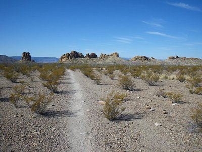
Up to 7 miles one-way. Start: Ross Maxwell Scenic Dr., Mile 13, or Old Maverick
A terrific, open desert trail that provides a great taste of the park, with a gradual elevation gradient. Start at the parking area at the 13-mile mark of Ross Maxwell Scenic Dr. A good run is 2.4 miles each way to reach the Chimneys (high pinnacles). It’s possible to run 7 miles one way to Old Maverick Road near Luna’s jacal, especially if you have a shuttle partner! Or, start at the Old Maverick End. The dirt trail is a good surface for running.
Mountain Trails in the Chisos Basin Area
The Chisos Basin Visitor Center is a focal point for some of the best mountain hiking in Big Bend NP. There are some good running options here, but most involve climbs and some challenging footing. A few options, from the Visitor Center:
Laguna Meadows Trail. MAP. One of the gentler trails in the area. The first two miles are more gradual, with a ~500 foot climb. After that, it’s more intense, to 3.6 miles and the intersection with the Colima Trail. A shorter, gentler option is to combine the beginning of the Laguna Meadows Trail with the Chisos Basin Loop Trail (~1.7 mile loop).
Boot Canyon. MAP More of a run/hike, but a nice opportunity for a more shaded run, with big trees and cooler temps. From the visitor center, the Pinnacles Trail is 2.9 miles, steady climb. Very steep near Pinnacles Pass. Then join the Boot Canyon Trail, which is less of a climb, to the intersection with the NE Rim Trail, at 4.5 miles. It’s another ~1 mile to the intersection with the South Rim Trail. Note: this is a challenging run. And be aware of possible bear and mountain lion.
Rio Grande River Trail
2.8 miles one way. Start: Daniels Ranch, near Rio Grande Village
A run and hot springs – what could be better? The Rio Grande Hot Springs Trail goes from Daniels Ranch, near the Rio Grande Visitor Center, for 2.8 miles one-way to Hot Springs Rd. The hot springs are at about the 2.3 mile mark. The trail is steep and rugged at first, climbing 300 feet in the first half mile along a series of stairs and switchbacks to a rim with good views of the river. The last mile of the trail is along the river.
Roads for Running
There are 250 miles of roads in Big Bend National Park. Some of the roads, such as Chisos Basin Rd. and the road from Panther Junction to Rio Grande Village are long and have significant elevation. The roads in the park are fine to run. Even though many don’t have a shoulder, there is not significant road traffic, except perhaps in high season. Our recommended roads and sections for running are:
Ross Maxwell Scenic Drive. MAP. 30-mile road is the signature drive in the park, with many scenic overlooks and exhibits, including Sotol Vista, Mule Ears Overlook, and Tuff Canyon. Among the wonderful vistas, runners might particularly enjoy the Santa Elena Canyon vistas near the western end of the route. The total elevation gain is 1682 feet over 30 miles. The first 8 miles climb about 1,000 feet, with the steepest section between between miles 6.5 and 7.5, at 7% grade, just north of the Upper Burro Mesa Trail. Miles 8-12 are a steady downhill, with a couple of steep sections, and the southern half of the drive is fairly flat.
Maverick Entrance Station to Panther Junction. MAP. About 23 miles, known as the park route between Maverick and Panther Junction. in along Panther Junction Rd. & Gano Springs Rd. . Beautiful desert scenery, and great mountain views. The section closer to Maverick Junction has a gradual climb, and the section closer to Panther Junction is level to declining. The entire road gives great vistas of the Chisos, Christmas, and Rosillos Mountains
Old Maverick Rd. MAP. A nearly 14-mile dirt road passing along the Terlingua Creek badlands on the west side of the park, descending to the Rio Grande and Santa Elena. One of the flatter roads for running in Big Bend NP.
At more than 800,000 acres, Big Bend National Park is unique, remote, and isolated. It is in southwestern Texas, 330 miles from El Paso. There are mountains, desert, and 120 miles along the Rio Grande River, which separates the United States and Mexico. There are some 1,200 species of plants, more than 450 species of birds, 56 species of reptiles, 75 species of mammals, as well as fossils and historic landscapes and buildings. Due the park’s size, remoteness, and climate, one has to choose where and when to run carefully. Among the best places to run in Big Bend National Park are some of the more accessible trails, such as the Chimneys Trail, Boot Canyon, and along the Rio Grande. Some of the roads are also good for running, especially off season. The high season for Big Bend National Park is February to April, where there is desert bloom and the weather is best. Summers are very hot, with temperatures typically exceeding 100F. PRO TIP: Gorgeous Bluebonnets, March to May.
Notes:
Please plan and hydrate accordingly.
Some Visitor Centers are closed in summer.
Exercise caution regarding wildlife — bears, mountain lions, and snakes can pose a danger. Best to run on an open trail with good vistas, and recommended to bring a whistle, especially if you are alone or in a more remote area.
Up to 7 miles one-way. Start: Ross Maxwell Scenic Dr., Mile 13, or Old Maverick
A terrific, open desert trail that provides a great taste of the park, with a gradual elevation gradient. Start at the parking area at the 13-mile mark of Ross Maxwell Scenic Dr. A good run is 2.4 miles each way to reach the Chimneys (high pinnacles). It’s possible to run 7 miles one way to Old Maverick Road near Luna’s jacal, especially if you have a shuttle partner! Or, start at the Old Maverick End. The dirt trail is a good surface for running.
Mountain Trails in the Chisos Basin Area
The Chisos Basin Visitor Center is a focal point for some of the best mountain hiking in Big Bend NP. There are some good running options here, but most involve climbs and some challenging footing. A few options, from the Visitor Center:
Laguna Meadows Trail. MAP. One of the gentler trails in the area. The first two miles are more gradual, with a ~500 foot climb. After that, it’s more intense, to 3.6 miles and the intersection with the Colima Trail. A shorter, gentler option is to combine the beginning of the Laguna Meadows Trail with the Chisos Basin Loop Trail (~1.7 mile loop).
Boot Canyon. MAP More of a run/hike, but a nice opportunity for a more shaded run, with big trees and cooler temps. From the visitor center, the Pinnacles Trail is 2.9 miles, steady climb. Very steep near Pinnacles Pass. Then join the Boot Canyon Trail, which is less of a climb, to the intersection with the NE Rim Trail, at 4.5 miles. It’s another ~1 mile to the intersection with the South Rim Trail. Note: this is a challenging run. And be aware of possible bear and mountain lion.
Rio Grande River Trail
2.8 miles one way. Start: Daniels Ranch, near Rio Grande Village
A run and hot springs – what could be better? The Rio Grande Hot Springs Trail goes from Daniels Ranch, near the Rio Grande Visitor Center, for 2.8 miles one-way to Hot Springs Rd. The hot springs are at about the 2.3 mile mark. The trail is steep and rugged at first, climbing 300 feet in the first half mile along a series of stairs and switchbacks to a rim with good views of the river. The last mile of the trail is along the river.
Roads for Running
There are 250 miles of roads in Big Bend National Park. Some of the roads, such as Chisos Basin Rd. and the road from Panther Junction to Rio Grande Village are long and have significant elevation. The roads in the park are fine to run. Even though many don’t have a shoulder, there is not significant road traffic, except perhaps in high season. Our recommended roads and sections for running are:
Ross Maxwell Scenic Drive. MAP. 30-mile road is the signature drive in the park, with many scenic overlooks and exhibits, including Sotol Vista, Mule Ears Overlook, and Tuff Canyon. Among the wonderful vistas, runners might particularly enjoy the Santa Elena Canyon vistas near the western end of the route. The total elevation gain is 1682 feet over 30 miles. The first 8 miles climb about 1,000 feet, with the steepest section between between miles 6.5 and 7.5, at 7% grade, just north of the Upper Burro Mesa Trail. Miles 8-12 are a steady downhill, with a couple of steep sections, and the southern half of the drive is fairly flat.
Maverick Entrance Station to Panther Junction. MAP. About 23 miles, known as the park route between Maverick and Panther Junction. in along Panther Junction Rd. & Gano Springs Rd. . Beautiful desert scenery, and great mountain views. The section closer to Maverick Junction has a gradual climb, and the section closer to Panther Junction is level to declining. The entire road gives great vistas of the Chisos, Christmas, and Rosillos Mountains
Old Maverick Rd. MAP. A nearly 14-mile dirt road passing along the Terlingua Creek badlands on the west side of the park, descending to the Rio Grande and Santa Elena. One of the flatter roads for running in Big Bend NP.
Our selection of the 1-2 'must do' runs in the major U.S. national parks. The focus is on the most scenic, safe, and accessible spots for a run, geared toward the everyday runner.
The Park Loop Road is great for running, especially the 5 mile section between Seal Beach and Little Hunters Beach. The Carriage Roads are special for running, with many options. And for a true challenge, run up Cadillac Mountain!
75 miles from Washington, D.C., featuring the famed 105 mile Skyline Drive. Wonderful drive touring and hiking opportunities. Good running options along some of the gentler trails and fire roads. Trail runners will find lots of options here too!
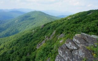
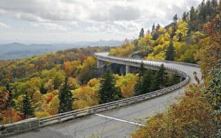
469-mile scenic road features stunning vistas, rugged mountains, and pastoral landscapes. With no shoulder, the Parkway and isn't great for running. We've researched the more runnable hiking trails and also recommend the carriage roads of Moses Cone Park.
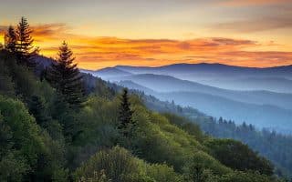
America's most visited National Park. A great option for runners is the Cades Cove Loop Road, which runs 11 miles one-way. Also good running in the Greenbrier Cove area. Famous for wildflowers!
Huge park southwest of Miami with 1.5 million acres of wetland. Some of the best spots for running are the Shark Valley Bike Trail, Pinelands trails, the Old Ingraham Highway Trail and the Flamingo area trails.
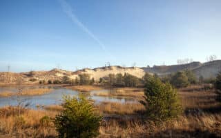
Located only an hour from Chicago, Indiana Dunes National Park is known for its spectacular dunes, wetlands, forests, and beaches. We've researched the best running options among the 50 miles of hiking trails and 37 miles of bike trails.
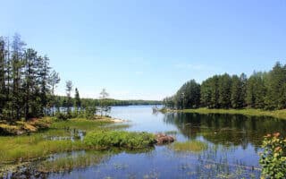
Water-based National Park with a series of interconnected waterways. Some scenic trails for running near the three Visitor Centers, featuring forests, marshes, wetlands, and lakes. Spectacular for running in winter, with trails and "ice roads"!
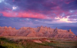
Dramatic landscapes spanning layered rock formations, steep canyons and towering spires. Best spots for running are along the Badlands Loop Scenic Highway, Sage Creek Rim Road, Castle Trail, and Sheep Mountain Table Rd.
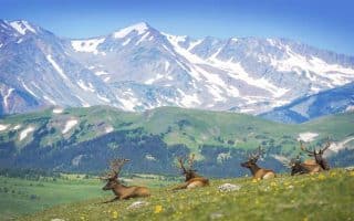
Wonderful park within 90 minutes of Denver. Majestic mountain views, mountain lakes, wooded forests, mountain tundra. Best running options are trails around Cub Lake, Lily Lake,Upper Beaver Meadow, and Emerald Lake.
Park in southwestern Colorado is a glimpse into communities that the Pueblo people built on the mesas and in the cliffs. 30 miles of hiking trails around mesas, and into rugged canyons. Best for running is the 5-mile Long House Loop.
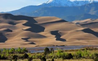
North America's tallest dunes, and terrain that also alpine peaks, forest, grasslands, and wetlands. Running the dunes is a singular experience but also very challenging. Best bet for running in the park are the miles of grasslands trails.
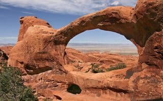
Along with Canyonlands NP, located in the outdoor recreational mecca around Moab, UT. For Arches, we recommend running the Landscape Arch, a nice 2-mile route starting at Devils Garden Trailhead. Arches Scenic Dr. is also runnable.
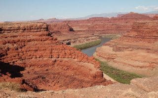
This area, near Moab, is a mecca for biking, hiking, climbing and other adventuring activities. Great running options in Canyonlands are Colorado River Overlook trail, Neck Springs, and a trail along Murphy Point Overlook.
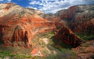
The two best options for running are the Pa’rus Trail, which is a 1.7 mile, flat path skirting the Virgin River in the flat, lower section of Zion Canyon, and the 6.2 miles Scenic Drive from the Visitor Center to Temple of Sinawava.
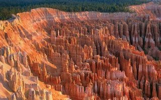
Bryce is marked by the salmon and orange-colored limestone that create a maze of spires, pinnacles and fins. Best running options are the new shared use bike path connecting Bryce and Red Canyon; and the 5.5 mile Rim Trail.
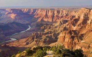
The best running options are in the South Rim section of massive Grand Canyon. Great running along the Rim Trail, the network of Greenways throughout the Village and surrounding communities, and the Arizona National Scenic Trail.
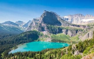
Pristine forests, alpine meadows, glacier-carved peaks, spectacular lakes, wildflowers! Fantastic trail running. We've included some gentler trail running options, plus some multi-use paths just outside the park in Kalispell & Hungry Horse.
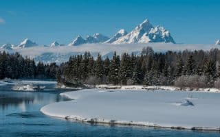
Showcasing the major peaks of the 40-mile-long Teton Range. Best for running in summer. Good options are the Grand Teton multi-use path, Taggart Lake Trail, and 6-mile loop around Two Ocean Lake.
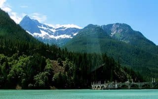
240,000 acre park, 2-hour drive from Seattle. Wonderful running opportunities, around valleys, waterfalls, subalpine meadows, old-growth forest and glaciers. Best routes are along some of the less traveled side roads and gentler hiking trails.
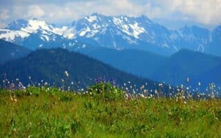
One of the closest national parks to a major metro area, the 1 million acre Olympic National Park has an incredible diversity of terrain, featuring snow-covered mountains, lush rain forests, and dramatic coastal terrain.
A stunning and diverse alpine landscape, less than three hours from Seattle. Generally it's more challenging trail running. Best running options are in Stekehin, accessed only by ferry. The MUST DO run is the first 6 miles of Stekehin Valley Road.
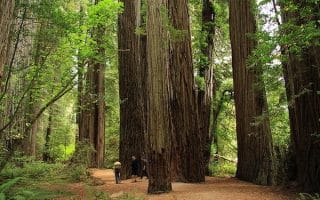
133,000-acre park located near the California-Oregon border features some of the tallest trees on earth, as well as vast prairies, oak woodlands, riverways, and 40 miles of rugged coastline. Our recommendations on the best trails, roads, and beaches for running.
The world’s first national park, showcasing colorful hot springs, mudpots, and geysers, in addition to its dramatic mountains, forests, lakes and wildlife. Several good running options -- read our caution note about wildlife. Video excerpt!
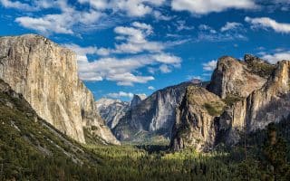
Waterfalls, deep valleys, grand meadows, ancient giant sequoias, a vast wilderness area in this 1,200 square mile park. Two good running options are the Yosemite Village Multi-Use Path, and Tuolumne Meadows.
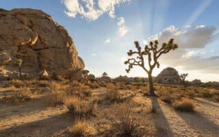
Not one of the better national parks for running, given the rugged, often sandy terrain, and summer heat. Best options are the backcountry roads, some of the easier hiking trails, and quiet residential streets in Yucca Valley & Desert Hot Springs.
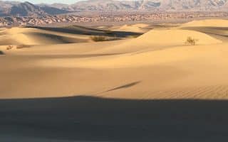
One of the more unique parks in terms of terrain, geography, and extreme weather. Fantastic opportunities for trail running -- though easy to get lost! Some good running options along park roads - sunrise/sunset are best.
Huge mountains, rugged foothills, deep canyons, vast caverns, and the world’s largest trees in these side-by-side parks. Recommended running: Roaring Rivers to Zumwalt Meadows Loop in Kings and Crescent Meadow Trail and Road.
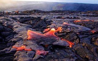
A one-of-a-kind run on a barren volcano, with incredible ocean views. Very challenging 10-mile run to the 10,000-foot summit is 3,000 foot gain. Or, have a partner drop you part way or go up for sunrise and run down.
A one-of-a kind place. Hike or run the rim of an active crater, or run on trails or roads to enjoy terrain that includes deserts and rain forests, past craters and rift zones. We outline several good options. Note trail closures and air quality warnings!
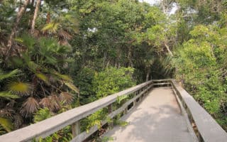
Virgin Islands National Park comprises 60% of the land mass of the St. John in the U.S. Virgin Islands. Numerous trails in the park are good for running, notably the Francis Bay Trail to Leinster Point, the Johnny Horn Trail, and Lind Point Trail.
Share your feedback on this route and see that of other Great Runs users. Click on the image icon to upload a photo. And please let us know if there are notes or changes we should incorporate!
 A terrific, open desert trail that provides a great taste of the park, with a gradual elevation gradient. Start at the parking area at the 13-mile mark of Ross Maxwell Scenic Dr. A good run is 2.4 miles each way to reach the Chimneys (high pinnacles). It’s possible to run 7 miles one way to Old Maverick Road near Luna’s jacal, especially if you have a shuttle partner! Or, start at the Old Maverick End. The dirt trail is a good surface for running.
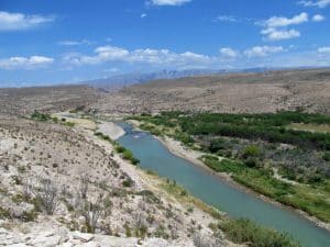 A run and hot springs – what could be better? The Rio Grande Hot Springs Trail goes from Daniels Ranch, near the Rio Grande Visitor Center, for 2.8 miles one-way to Hot Springs Rd. The hot springs are at about the 2.3 mile mark. The trail is steep and rugged at first, climbing 300 feet in the first half mile along a series of stairs and switchbacks to a rim with good views of the river. The last mile of the trail is along the river.


Review or Comment on This Route/Share a Photo!
Share your feedback on this route and see that of other Great Runs users. Click on the image icon to upload a photo. And please let us know if there are notes or changes we should incorporate!