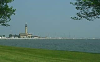
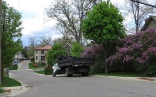
The greater metro area of Detroit is very large, with an extensive series of suburbs north of Detroit boasting numerous corporate offices and major residential neighborhoods. Here, we focus on the best places to run in the Pontiac, West Bloomfield Township, and Rochester areas. There’s an extensive series of linear parks and rail trails that are great for running. Particularly, the West Bloomfield Trail,Clinton River Trail, and Paint Creek Trail are interconnected. Near downtown Rochester, there’s an extensive series of linear parks.
West Bloomfield Trail (Pontiac south to W. Bloomfield Township).6.8 miles ONE-WAY, unpaved between Pontiac and W. Bloomfield. PDF MAP. A good option in the Pontiac/Auburn Hills area. One can start in Pontiac, and head south on a mainly unpaved rail trail south through the West Bloomfield township, where the trail ends near the West Bloomfield Nature Preserve. The northern 3 miles are especially pretty, as the trail bisects a series of lakes. At the north end at Orchard Lake Rd., connect to the Clinton River Trail (below). At the south end, connect to the Michigan Air Line Trail. ROUTE MAP
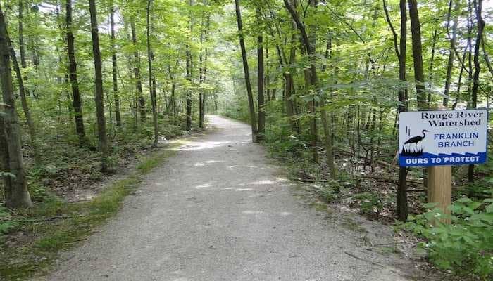
Clinton River Trail. Up to 15.4 miles ONE-WAY PDF MAP. This mainly unpaved trail connects Bloomfield Township/Pontiac and Rochester. From Bloomer Park in Rochester, the path heads southwest for 9.4 miles to S. Opdyke Rd., just west of I-75. After a 3.4 mile on-road section, the off-road trail picks up again for 2.5 miles to Sylvan Lake.
Add-Ons: at the Rochester end, connect to Rochester Municipal Park, the Rochester River Walk trail, and the Paint Creek Trail. Also, lots of trail running options in the linear park formed by Bloomer Park and River Bends Park. At the Sylvan Lake end, connect to the West Bloomfield Trail (above). Note:the first ~7 miles from Rochester is a steady uphill. ROUTE MAP
Paint Creek Trail. 8.9 miles, ONE-WAY between Rochester and Lake Orion. PDF MAP. This wide rails to trails multi-use path traverses through Rochester, Rochester Hills, Oakland Township, Orion Township and the Village of Lake Orion. Mainly unpaved. At the downtown Rochester end, nice connections to Rochester Municipal Park, the Rochester River Walk trail, and the Clinton River Trail.
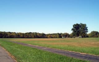
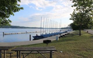
Stony Creek Metropark. A great destination run 38 miles north of downtown and just east of Rochester. The park consists of 4,400 acres and a 50-acre lake. Tons of trails for running, hiking, mountain biking — a combination of paved multi-use trails, nature trails, and more rustic trails. There’s a marked 6 mile loop, and a 1.9-mile FIT Trail. TRAIL MAP
The greater metro area of Detroit is very large, with an extensive series of suburbs north of Detroit boasting numerous corporate offices and major residential neighborhoods. Here, we focus on the best places to run in the Pontiac, West Bloomfield Township, and Rochester areas. There’s an extensive series of linear parks and rail trails that are great for running. Particularly, the West Bloomfield Trail,Clinton River Trail, and Paint Creek Trail are interconnected. Near downtown Rochester, there’s an extensive series of linear parks.
West Bloomfield Trail (Pontiac south to W. Bloomfield Township).6.8 miles ONE-WAY, unpaved between Pontiac and W. Bloomfield. PDF MAP. A good option in the Pontiac/Auburn Hills area. One can start in Pontiac, and head south on a mainly unpaved rail trail south through the West Bloomfield township, where the trail ends near the West Bloomfield Nature Preserve. The northern 3 miles are especially pretty, as the trail bisects a series of lakes. At the north end at Orchard Lake Rd., connect to the Clinton River Trail (below). At the south end, connect to the Michigan Air Line Trail. ROUTE MAP
Clinton River Trail. Up to 15.4 miles ONE-WAY PDF MAP. This mainly unpaved trail connects Bloomfield Township/Pontiac and Rochester. From Bloomer Park in Rochester, the path heads southwest for 9.4 miles to S. Opdyke Rd., just west of I-75. After a 3.4 mile on-road section, the off-road trail picks up again for 2.5 miles to Sylvan Lake.
Add-Ons: at the Rochester end, connect to Rochester Municipal Park, the Rochester River Walk trail, and the Paint Creek Trail. Also, lots of trail running options in the linear park formed by Bloomer Park and River Bends Park. At the Sylvan Lake end, connect to the West Bloomfield Trail (above). Note:the first ~7 miles from Rochester is a steady uphill. ROUTE MAP
Paint Creek Trail. 8.9 miles, ONE-WAY between Rochester and Lake Orion. PDF MAP. This wide rails to trails multi-use path traverses through Rochester, Rochester Hills, Oakland Township, Orion Township and the Village of Lake Orion. Mainly unpaved. At the downtown Rochester end, nice connections to Rochester Municipal Park, the Rochester River Walk trail, and the Clinton River Trail.
Stony Creek Metropark. A great destination run 38 miles north of downtown and just east of Rochester. The park consists of 4,400 acres and a 50-acre lake. Tons of trails for running, hiking, mountain biking — a combination of paved multi-use trails, nature trails, and more rustic trails. There’s a marked 6 mile loop, and a 1.9-mile FIT Trail. TRAIL MAP
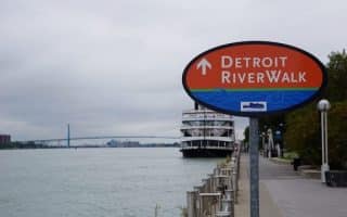
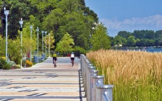
The signature running route in Detroit. Paved multi-use path runs for 5 miles along the Detroit River. Nice water views, several parks & some important Detroit sites. Accessible from downtown hotels. Add-ons: Dequindre Cut Greenway, Southwest Greenway.
A great off-road running option in downtown Detroit, this ~2 mile greenway runs from Atwater Ave. to Mack Ave., following a former railroad line. A unique feature is a series of 16 murals along the way. Good add-on to Riverwalk path.
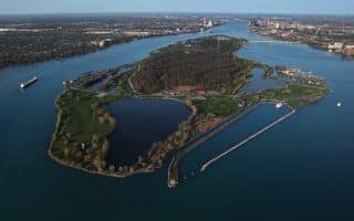
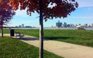
Olmsted-designed park on an island in the middle of the Detroit River, with views of the Detroit skyline & the Windsor shore. Great paths for running, including 6-mile perimeter road.
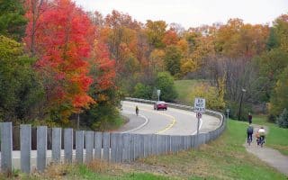
For travelers in the Dearborn (Ford HQ) and Northville areas, there are good opportunities for running. The Hines Park Trail is a paved path between Dearborn and Northville.
See auto exec mansions along the winding country lanes of Bloomfield Hills, north of Detroit. Combine with the adjacent Birmingham neighborhood, which has leafy streets and attractive homes.
The best places to run in Detroit’s major western suburbs off I-275, from Huron Township near the Airport north to Northville. The highlight is the linear park from Lower Huron MetroPark to Oakwoods MetroPark. The I-275 Metro Trail is a good anchor.
For a fun running excursion, Kensington MetroPark and adjacent Island Lake Recreation Area offer thousands of acres of recreation opportunities and miles of trails for running. Combination of developed multi-use trails and more rugged trails.
Share your feedback on this route and see that of other Great Runs users. Click on the image icon to upload a photo. And please let us know if there are notes or changes we should incorporate!


Review or Comment on This Route/Share a Photo!
Share your feedback on this route and see that of other Great Runs users. Click on the image icon to upload a photo. And please let us know if there are notes or changes we should incorporate!