Our running guide to the East London suburbs includes Hackney, Newham, Waltham Forest, and Redbridge, and southeast of the city in Greenwich and Bexle.
North of River
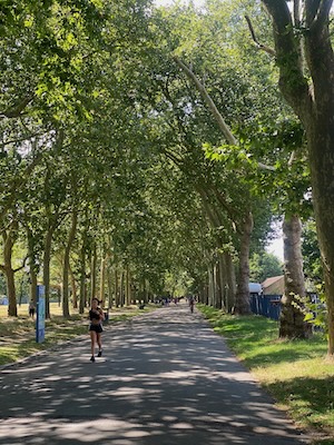
Victoria Park: Kassie Helm
Queen Elizabeth Olympic Park/Victoria Park/Hackney Marshes: This is a great run if you end up in east London. There are three “sites” incorporated on this route: pathways along the several canals, where there are many runners and bikers as well as some pop up coffee shops by the water ; a jaunt by the area built for the 2012 summer Olympics, and a run into gorgeous Victoria Park.
Start at the Mile End tube station, which is 1 mile south of Victoria Park. Head north to the Park, then ~1 mile through the Park to Queen Elizabeth Olympic Park, where you can take a quick detour to view the sites, including the 2012 Olympic Rings. There are numerous paths and also the London Marathon Community Track, which has public hours. Then head south along the River Lea, for ~2 miles, east along the Limestone Cut path for a mile, and north along the Regents Canal and greenway back to the start. Olympic Park Route MAP. PRO TIPS: The north/ top end of Victoria Park is much nicer to run than the bottom.
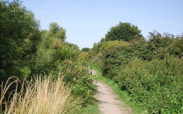
Canal Path. Kassie Helm
Longer Option: head further west along the Regents Canal path, which is ~2 miles between Victoria Park and the Angel Tube station.
Hackney Marshes. Internationally known as the spiritual home of Sunday league football, with 82 football rugby and cricket pitches on North and South Marsh and Mabley Green. Run along River Lea paths at the edge of Hackney Marshes, or on the large area of green fields when there aren’t games in session. Easy to do 3-4 miles here. It’s just north of Queen Elizabeth Park, across the A12, with a connecting path. We’ve mapped a 5-mile loop of the River Lea/River Lee Navigation paths from Queen Elizabeth Park & around the Hackney Marshes. Hackney Marshes Route MAP.
Extension Option: Extend all the way to the Walthamstow Marhes/Wetlands. There are lovely paths around wetlands. Note this is a popular birding area. Jogging is permitted but use discretion. See this 11.5 mile route done by friend of Great Runs Kassie Helm! ROUTE MAP
Wanstead Park: Wanstead Park is a favorite of local running clubs and home to a free Saturday 5k Parkrun. Visitors can take a running tour of the area at any time, starting from the Wanstead High School area. Run south on gravel trails along the River Rodding, then west along Heronry Pond, and north toward Snaresbrook. Our 10 km loop follows a common training route of the East London Runners. Wanstead Park Route MAP.
South of River
Greenwich Park & Blackheath: Run across the Meridian Line at Greenwich Park! The Royal Observatory in Greenwich Park has a great exhibit about the the history of the Meridian Line, and there’s a spot where you can step between the Eastern and Western hemispheres — tick that one off the ‘ol runners’ bucket list! Greenwich Park is a large, lovely park with criss-crossing paths, large meadows, and paths through a free botanical garden. A hill leads to the Royal Observatory. There are also some additional paths just south of the park in Blackheath, just across Charlton Way. Continue along the Thames for more mileage. Blackheath Route MAP.
Cray Riverway: A pretty, long distance path stretching from Erith to Bexley Station, this 16 km (one-way) Cray Riverway is a flat gravel route through some of the best marsh scenery around London. Runners can follow the route as an out and back or take the train one way. Cray Riverway Route MAP. Route INFO and Detailed Directions.
Our running guide to the East London suburbs includes Hackney, Newham, Waltham Forest, and Redbridge, and southeast of the city in Greenwich and Bexle.
North of River
Victoria Park: Kassie Helm
Queen Elizabeth Olympic Park/Victoria Park/Hackney Marshes: This is a great run if you end up in east London. There are three “sites” incorporated on this route: pathways along the several canals, where there are many runners and bikers as well as some pop up coffee shops by the water ; a jaunt by the area built for the 2012 summer Olympics, and a run into gorgeous Victoria Park.
Start at the Mile End tube station, which is 1 mile south of Victoria Park. Head north to the Park, then ~1 mile through the Park to Queen Elizabeth Olympic Park, where you can take a quick detour to view the sites, including the 2012 Olympic Rings. There are numerous paths and also the London Marathon Community Track, which has public hours. Then head south along the River Lea, for ~2 miles, east along the Limestone Cut path for a mile, and north along the Regents Canal and greenway back to the start. Olympic Park Route MAP. PRO TIPS: The north/ top end of Victoria Park is much nicer to run than the bottom.
Canal Path. Kassie Helm
Longer Option: head further west along the Regents Canal path, which is ~2 miles between Victoria Park and the Angel Tube station.
Hackney Marshes. Internationally known as the spiritual home of Sunday league football, with 82 football rugby and cricket pitches on North and South Marsh and Mabley Green. Run along River Lea paths at the edge of Hackney Marshes, or on the large area of green fields when there aren’t games in session. Easy to do 3-4 miles here. It’s just north of Queen Elizabeth Park, across the A12, with a connecting path. We’ve mapped a 5-mile loop of the River Lea/River Lee Navigation paths from Queen Elizabeth Park & around the Hackney Marshes. Hackney Marshes Route MAP.
Extension Option: Extend all the way to the Walthamstow Marhes/Wetlands. There are lovely paths around wetlands. Note this is a popular birding area. Jogging is permitted but use discretion. See this 11.5 mile route done by friend of Great Runs Kassie Helm! ROUTE MAP
Wanstead Park: Wanstead Park is a favorite of local running clubs and home to a free Saturday 5k Parkrun. Visitors can take a running tour of the area at any time, starting from the Wanstead High School area. Run south on gravel trails along the River Rodding, then west along Heronry Pond, and north toward Snaresbrook. Our 10 km loop follows a common training route of the East London Runners. Wanstead Park Route MAP.
South of River
Greenwich Park & Blackheath: Run across the Meridian Line at Greenwich Park! The Royal Observatory in Greenwich Park has a great exhibit about the the history of the Meridian Line, and there’s a spot where you can step between the Eastern and Western hemispheres — tick that one off the ‘ol runners’ bucket list! Greenwich Park is a large, lovely park with criss-crossing paths, large meadows, and paths through a free botanical garden. A hill leads to the Royal Observatory. There are also some additional paths just south of the park in Blackheath, just across Charlton Way. Continue along the Thames for more mileage. Blackheath Route MAP.
Cray Riverway: A pretty, long distance path stretching from Erith to Bexley Station, this 16 km (one-way) Cray Riverway is a flat gravel route through some of the best marsh scenery around London. Runners can follow the route as an out and back or take the train one way. Cray Riverway Route MAP. Route INFO and Detailed Directions.
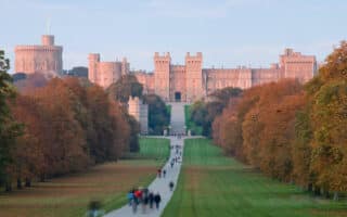
Just west of the M25, this is a popular visitor destination. We love running the Long Walk and Windsor Great Park, paths along the Thames River and Jubilee River, Dorney Lake, and the historic, bucolic campus of Eton College.
Share your feedback on this route and see that of other Great Runs users. Click on the image icon to upload a photo. And please let us know if there are notes or changes we should incorporate!


Review or Comment on This Route/Share a Photo!
Share your feedback on this route and see that of other Great Runs users. Click on the image icon to upload a photo. And please let us know if there are notes or changes we should incorporate!