In addition to our central Main River route in Frankfurt, it’s possible to take an even longer run, adding as much as 15 km east to Hanau. A multi-use path runs along the south bank of the river, almost continuously from Frankfurt to Hanau. One fun option: run one-way to Hanau and take the train back (Hanau West or Steinheim)
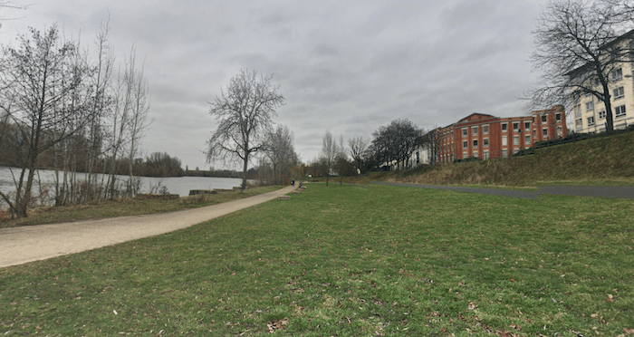
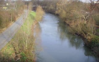
Our route starts at Carl-Ulrich-Brücke, about 5 km east of central Frankfurt (see our central Main River route to run from central Frankfurt). Just follow the path along the water — the terrain alternates between water views and some more wooded sections, becoming quite pastoral. Below are some distances and highlights, from Carl-Ulrich-Brücke:
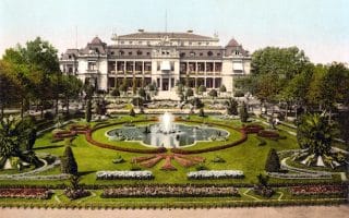
Rumpenheimer Schloss. CC: Fritz Geller-Grimm
3 km: Bürgel Sports Complex
3.8 km: Arthur-von-Weinberg-Steg — Pedestrian Bridge to paths on North Bank
7 km: Rumpenheimer Schloss: Castle park & estate. Do a loop around the park!
11 km: Nachenhafen Dietesheim. Walking & hiking area
15 km: Steinheimer Brücke – bridge to cross into Hanau
In addition to our central Main River route in Frankfurt, it’s possible to take an even longer run, adding as much as 15 km east to Hanau. A multi-use path runs along the south bank of the river, almost continuously from Frankfurt to Hanau. One fun option: run one-way to Hanau and take the train back (Hanau West or Steinheim)
Our route starts at Carl-Ulrich-Brücke, about 5 km east of central Frankfurt (see our central Main River route to run from central Frankfurt). Just follow the path along the water — the terrain alternates between water views and some more wooded sections, becoming quite pastoral. Below are some distances and highlights, from Carl-Ulrich-Brücke:
Rumpenheimer Schloss. CC: Fritz Geller-Grimm
3 km: Bürgel Sports Complex
3.8 km: Arthur-von-Weinberg-Steg — Pedestrian Bridge to paths on North Bank
7 km: Rumpenheimer Schloss: Castle park & estate. Do a loop around the park!
11 km: Nachenhafen Dietesheim. Walking & hiking area
15 km: Steinheimer Brücke – bridge to cross into Hanau
Scroll Down For Route Maps
Essentials
Up to 15 km from Carl-Ulrich-Brücke to Hanau. From central Frankfurt, add another 5 km
Flat
Carl-Ulrich-Brücke, 5 km east of central Frankfurt
If taking the train back from Hanau, can use Hanau West or Steinheim
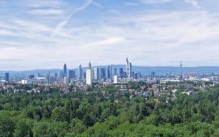
This 'runseeing' tour of Frankfurt hits both the historic and scenic highlights of the main part of the city: Altstadt, Zeil shopping promenade, the linear park, Grüneburgpark botanical gardens, Eurotower, river path.
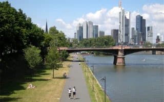
Among the signature runs in Frankfurt. Wonderful waterfront paths with great views. South side features the green belt along the Museum Embankment, while the north side skirts the Altstadt. Numerous bridges allow for loops of varying lengths.
Three neighboring green spaces in the northwest part of Frankfurt. Enjoy the botanical gardens of Palmengarten, and then Grüneburgpark, whose paths are done in the English style. Also includes a quick jaunt through the campus of Goethe University.
A series of park lands around the former city walls, making for a nearly 5 km green belt. A great way to skirt the perimeter of old and new Frankfurt, through seven areas named after former city gates. Add on by running along the Main river paths.
Pleasant, flat path along this tributary of the Main river. Runs 10.5 km from Höchst, north to Eschersheim. Nice views of the river, and increasingly country-like as you head north. Good public transport access at either end.
Huge city park about 7 km south of the city, with 450 km of trails. Lots of options running, from gentler terrain through fields, to good trail running options. Well signposted. Visitor Center has maps & info. Western section is near the airport!
An enjoyable run in Hanau, located 25 km east of Frankfurt. Our 9.7 km loop features the scenic grounds of the Schloss Philippsruhe (castle) and paths along the Main River.
Share your feedback on this route and see that of other Great Runs users. Click on the image icon to upload a photo. And please let us know if there are notes or changes we should incorporate!
Subscribe
0 Comments
Oldest
Newest
Inline Feedbacks
View all comments
Essentials
Up to 15 km from Carl-Ulrich-Brücke to Hanau. From central Frankfurt, add another 5 km
Flat
Carl-Ulrich-Brücke, 5 km east of central Frankfurt
If taking the train back from Hanau, can use Hanau West or Steinheim


Review or Comment on This Route/Share a Photo!
Share your feedback on this route and see that of other Great Runs users. Click on the image icon to upload a photo. And please let us know if there are notes or changes we should incorporate!