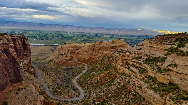
Run on what is considered to be one of the most scenic roads in the United States! The Colorado National Monument, run by the National Park Service, is an area of desert land high on the Colorado Plateau. There are sheer-walled red-rock canyons, with pinyon and juniper forests on the plateau. Rim Rock Drive is a 23-mile scenic road, offering a vast panorama, traveling between the park’s east entrance in Grand Junction and the west entrance in Fruita.
It is possible to run on Rim Rock Drive — in fact, it’s popular for cycling. [Note: it is steep, there’s no shoulder, and there are three tunnels. There can be trucks on 4 miles on the eastern side.] The full Rim Rock Drive is a 2,300 foot climb. To avoid some of the steepest hills, choose a section west of the Visitor Center, which is 4 miles from the western entrance near Fruita.
Add-Ons: There are several hiking trails that are also good for trail running.

Review or Comment on This Route/Share a Photo!
Share your feedback on this route and see that of other Great Runs users. Click on the image icon to upload a photo. And please let us know if there are notes or changes we should incorporate!