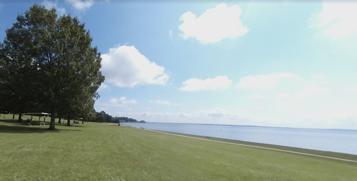
There’s some scenic waterfront running in Ridgeland, a northeast suburb of Jackson. The eastern end of Ridgeland overlooks the Ross R Barnett Reservoir. We’ve mapped a route of 10+ miles one-way, so best to choose a section.
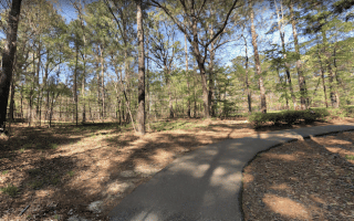
Old Trace Park/Dyke Rd. Section. A great place to start, and the most scenic and accessible section of our route, starts near Old Trace Park (alternatively you can park and start at northern terminus of the Chisha Foka Multi-Use Trail, at milepost 105.6 of the Parkway). A paved multi-use path runs through this pleasant waterfront park. Then, continue on Dyke Rd., right along the water, with great views, for 2 miles to the pier at Breakers Ln. This would be a nice 6-mile out and back.
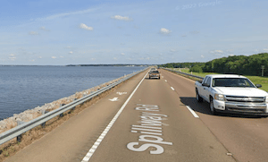
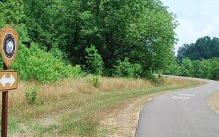
Spillway Rd. Section. Continue south on Spillway Rd. This four lane road runs right along the water. It’s a wide road with fast-moving cars, but there’s a decent shoulder on the water side of then road, with water views the whole way. It’s 3.6 miles south to Lakeahore Dr.
Causeway Section. Google Street View
Woodlake Area and Bridge. From the Spillway Rd./Lakeshore Dr. intersection, continue on the multi-use path alongside Lakeshroe Dr. for ~1 mile, and do a loop around the two small, pleasant waterfront parks — Bobby Cleveland Park and Pelahatchie Shore Park. Each of them are ~1 mile. Then if you’d like, continue on the North Shore Parkway, a 1.5 causeway over the Reservoir. It’s a busy road with fast moving traffic, but there’s a wide shoulder. Great water views!
Add-Ons:
Combine with a section of the Chisha Foka Multi-Use Trail, whose northern terminus is 1 mile north of Old Trace Park at Milepost 105.6 of the Natchez Trace Parkway.
Mule Jail Trail. Located below the Reservoir Dam and accessed from Spillway Road while traveling east from Ridgeland. There is a small parking area just off the exit ramp from Spillway Road before going over the dam. It is a 3.5 mile loop trail which runs around cypress swamps and is maintained by Pearl River Valley Association. There are signs throughout the property. It is closed during hunting season and open Feb- Sept. Note this is a trail run.
There’s some scenic waterfront running in Ridgeland, a northeast suburb of Jackson. The eastern end of Ridgeland overlooks the Ross R Barnett Reservoir. We’ve mapped a route of 10+ miles one-way, so best to choose a section.
Old Trace Park/Dyke Rd. Section. A great place to start, and the most scenic and accessible section of our route, starts near Old Trace Park (alternatively you can park and start at northern terminus of the Chisha Foka Multi-Use Trail, at milepost 105.6 of the Parkway). A paved multi-use path runs through this pleasant waterfront park. Then, continue on Dyke Rd., right along the water, with great views, for 2 miles to the pier at Breakers Ln. This would be a nice 6-mile out and back.
Spillway Rd. Section. Continue south on Spillway Rd. This four lane road runs right along the water. It’s a wide road with fast-moving cars, but there’s a decent shoulder on the water side of then road, with water views the whole way. It’s 3.6 miles south to Lakeahore Dr.
Causeway Section. Google Street View
Woodlake Area and Bridge. From the Spillway Rd./Lakeshore Dr. intersection, continue on the multi-use path alongside Lakeshroe Dr. for ~1 mile, and do a loop around the two small, pleasant waterfront parks — Bobby Cleveland Park and Pelahatchie Shore Park. Each of them are ~1 mile. Then if you’d like, continue on the North Shore Parkway, a 1.5 causeway over the Reservoir. It’s a busy road with fast moving traffic, but there’s a wide shoulder. Great water views!
Add-Ons:
Combine with a section of the Chisha Foka Multi-Use Trail, whose northern terminus is 1 mile north of Old Trace Park at Milepost 105.6 of the Natchez Trace Parkway.
Mule Jail Trail. Located below the Reservoir Dam and accessed from Spillway Road while traveling east from Ridgeland. There is a small parking area just off the exit ramp from Spillway Road before going over the dam. It is a 3.5 mile loop trail which runs around cypress swamps and is maintained by Pearl River Valley Association. There are signs throughout the property. It is closed during hunting season and open Feb- Sept. Note this is a trail run.
Scroll Down For Route Maps
Essentials
We've mapped 10.7 miles -- choose a section!
Fairly flat
Depends on section chosen. Best access is near Old Trace Park at the north end, or Woodlake at the south end
Best access is near Old Trace Park at the north end, or Woodlake at the south end
A pleasant 4-mile loop exploring the Mississippi State Capitol area and the attractive Bellhaven neighborhood, with its leafy residential streets and some historic homes. Good add-on options.
In the northern part of Jackson, LeFleur's Bluff State Park is a lush green spot for a run. The 305-acre state park features 2-3 miles of nature trails. For more, explore the Bellhaven & Eastover neighborhoods.
In the Flowood area in northern Jackson, stitch together a decent run combining Flowood Nature Park, Winners Circle Park, & Flowood Nature Park, using the multi-use path connecting them. Good option near airport!
This 10.5 mile paved multi-use path runs parallel to a section of the Natchez Trace Parkway that passes just north of Jackson. Pleasantly wooded and the best option for a long off-road run in the area.
A 32-acre preserve of native forest in Clinton, located 11 miles northwest of Jackson. There are 2.3 miles of pleasant, wooded nature trails. Add on with paths around Mississippi College, where there's also a running track.
Share your feedback on this route and see that of other Great Runs users. Click on the image icon to upload a photo. And please let us know if there are notes or changes we should incorporate!
Subscribe
0 Comments
Oldest
Newest
Inline Feedbacks
View all comments
Essentials
We've mapped 10.7 miles -- choose a section!
Fairly flat
Depends on section chosen. Best access is near Old Trace Park at the north end, or Woodlake at the south end
Best access is near Old Trace Park at the north end, or Woodlake at the south end
 Spillway Rd. Section. Continue south on Spillway Rd. This four lane road runs right along the water. It’s a wide road with fast-moving cars, but there’s a decent shoulder on the water side of then road, with water views the whole way. It’s 3.6 miles south to Lakeahore Dr.
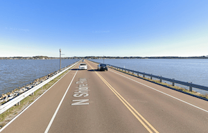


Review or Comment on This Route/Share a Photo!
Share your feedback on this route and see that of other Great Runs users. Click on the image icon to upload a photo. And please let us know if there are notes or changes we should incorporate!