As a coastal city along Osaka Bay, Kobe has plenty of waterfront running along its spacious promenades. There are numerous sections, not one long continuous path. Note that there are some industrial sections & busy roads that separate the different waterfront sections. Below are four distinct running options, from east to west:
HAT Yume Park to Minato No Mori Park. This is the longest of the promenades. It’s 2.5 km along the water to Saigogawakawaguchi Park. Runners can follow the path inland through Onohama Park and Minato No Mori Park for another 1.5 km. ROUTE MAP.
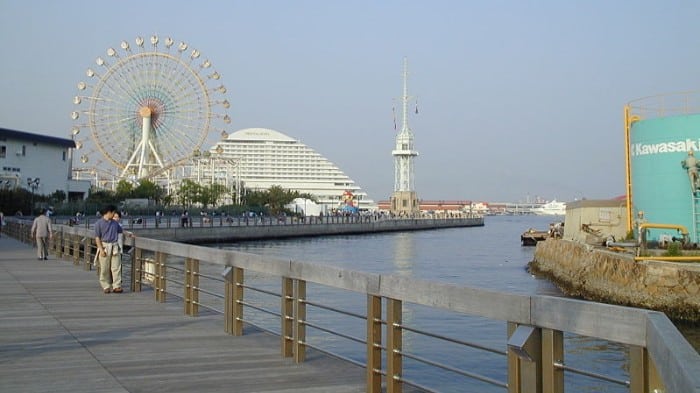
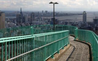
Harborland Park area. Photo: Mark Lowenstein
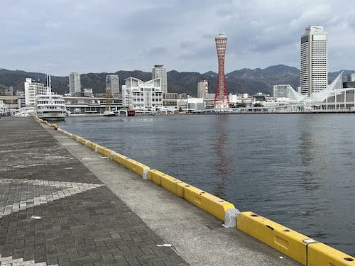
Meriken Park to Harborland Park. This 2.75 km section of walkway is one of the most scenic and festive areas of the Kobe Waterfront, passing by icons such as the Port of Kobe Earthquake Memorial Park, the Meriken Park murals, Kobe Port Tower, the Mosaic Ferris Wheel, and the Kobe Port Signal Station. It’s also centrally located, not too far from the main train station. ROUTE MAP.
Suma Promenade. Nice waterfront path along the Seaside Park beach from Suma Aqualife Park east for 2 km. ROUTE MAP
Maiko Marine Promenade. This section is further west, and goes for 2 km between the Akashi Kaiko Bridge and the public baths at the Maiki Beach Resort. The scenic promenade passes through Hyogo Prefectural Maiko Park and Maiko Higashi Seaside Park. ROUTE MAP.
As a coastal city along Osaka Bay, Kobe has plenty of waterfront running along its spacious promenades. There are numerous sections, not one long continuous path. Note that there are some industrial sections & busy roads that separate the different waterfront sections. Below are four distinct running options, from east to west:
HAT Yume Park to Minato No Mori Park. This is the longest of the promenades. It’s 2.5 km along the water to Saigogawakawaguchi Park. Runners can follow the path inland through Onohama Park and Minato No Mori Park for another 1.5 km. ROUTE MAP.
Harborland Park area. Photo: Mark Lowenstein
Meriken Park to Harborland Park. This 2.75 km section of walkway is one of the most scenic and festive areas of the Kobe Waterfront, passing by icons such as the Port of Kobe Earthquake Memorial Park, the Meriken Park murals, Kobe Port Tower, the Mosaic Ferris Wheel, and the Kobe Port Signal Station. It’s also centrally located, not too far from the main train station. ROUTE MAP.
Suma Promenade. Nice waterfront path along the Seaside Park beach from Suma Aqualife Park east for 2 km. ROUTE MAP
Maiko Marine Promenade. This section is further west, and goes for 2 km between the Akashi Kaiko Bridge and the public baths at the Maiki Beach Resort. The scenic promenade passes through Hyogo Prefectural Maiko Park and Maiko Higashi Seaside Park. ROUTE MAP.
The trail up Mount Maya beginning from Shin-Kobe Station is one of the most popular outdoor spaces in Kobe. Highlights of this uphill run include the Nunobiki Waterfall, an herb garden, and an Observation Deck.
This planned community, intended to support elders and foster community growth, is a great place to run on well-kempt sidewalks and paths. There's also a running track and numerous athletic facilities.
Enjoy stunning views of Osaka Bay from the top of the iconic Venus Bridge, and amp up your mileage on tree-lined paths along the Ujigawa River towards Ujigawa Park and Okurayama Park.
We’ve mapped out three of the best riverside towpaths in Kobe, including nice spots on the Toga River, the Sumiyoshi River, and the Shinminato River. All easily accessible via transport.
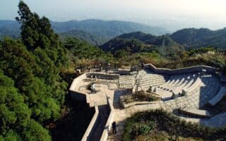
Run to the top of Kobe’s tallest mountain on a gentle dirt trail beginning at the gorgeous Rokko Garden Terrace. A not too hilly, 6 km out and back. Numerous other trail options, including an ascent from Ashiyagawa Station.
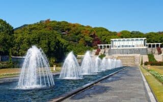
This gorgeous park of gardens and fountains in the Suma area has its own running track, but it can be combined with nearby walkways, the Botanical Gardens, or the Suma Promenade for more mileage.
Share your feedback on this route and see that of other Great Runs users. Click on the image icon to upload a photo. And please let us know if there are notes or changes we should incorporate!


Review or Comment on This Route/Share a Photo!
Share your feedback on this route and see that of other Great Runs users. Click on the image icon to upload a photo. And please let us know if there are notes or changes we should incorporate!