Coloane is a man-made island, only a couple of km from the hotels in the Macau New Urban Zone. A large park provides some excellent options for walking, running, and hiking. There are trails at the northeastern section and southeastern section.
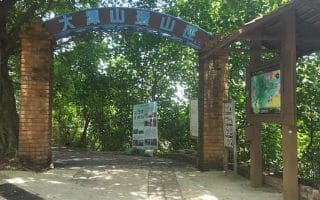
Coloane Trail(Trilho de Coloane) — the first and longest trail in Macau — forming an 8.1 km loop around the base of the mountain, and sitting about 100m above sea level. This is the signature route and is well way-marked and easy to follow. The path is mainly dirt, but is runnable. The terrain varies between flat sections, gradual inclines, and a couple of steeper spots. There are a couple of entrances/access points: the official entrance is near the Arboretum at the middle part of the Estrada do Alto de Coloane. Or, you can start at Seac Pai Van Park, take the (200+!) steps to the trail. It is the red line in the attached trail map. It can also be reached via the Fitness Walk Trail.
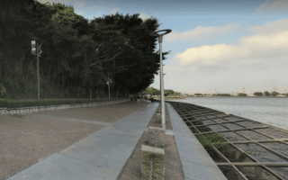
Coloane Fitness Walk (Circuito de Manutenção), which is a more walker/jogger friendly loop of 1.225 km. It is the blue line in the trail map. Starting point is at Intersection of Estrada do Alto de Coloane and Estrada Militar. It bisects with the Coloane Trail.
Morro de Hac Sa Family Trail. On the southeastern part of the island, this runnable 2.2 km loop is on a hillside and features great views of the South China Sea. Access: Intersection of Estrada de Choc Van and Estrada Nova de Hac Sá.
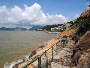
Long Chao Kok Coastal Trail
Long Chao Kok Coastal Trail. Coastal trail that runs right along the water for 1.2 km. It is runnable, but more of a trail run. Not too technical or challenging. Acccess: Rua de Hac-Sá Long Chao Kok (North), or Chuk Wan Hou Yuen (South). ROUTE MAP
Additional Options (from northeastern part of park)
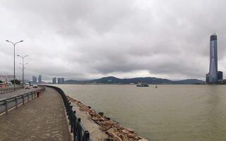
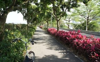
a) Run to charming Coloane Village, using Estrada de Seac Pai Van and heading south. Once at Coloane Village, there’s a nice waterfront sidewalk that runs for 0.6 km from Lord Stowe’s to the Tam Kong Temple along Av. de Cinco de Outubro.
b) Decent path/sidewalk along the water from Parque da Estrada do Dique Oeste at the western end of the Orient Golf Club, south for ~2 km to the end of R. Marginal da Concórdia.
Coloane is a man-made island, only a couple of km from the hotels in the Macau New Urban Zone. A large park provides some excellent options for walking, running, and hiking. There are trails at the northeastern section and southeastern section.
Coloane Trail(Trilho de Coloane) — the first and longest trail in Macau — forming an 8.1 km loop around the base of the mountain, and sitting about 100m above sea level. This is the signature route and is well way-marked and easy to follow. The path is mainly dirt, but is runnable. The terrain varies between flat sections, gradual inclines, and a couple of steeper spots. There are a couple of entrances/access points: the official entrance is near the Arboretum at the middle part of the Estrada do Alto de Coloane. Or, you can start at Seac Pai Van Park, take the (200+!) steps to the trail. It is the red line in the attached trail map. It can also be reached via the Fitness Walk Trail.
Coloane Fitness Walk (Circuito de Manutenção), which is a more walker/jogger friendly loop of 1.225 km. It is the blue line in the trail map. Starting point is at Intersection of Estrada do Alto de Coloane and Estrada Militar. It bisects with the Coloane Trail.
Morro de Hac Sa Family Trail. On the southeastern part of the island, this runnable 2.2 km loop is on a hillside and features great views of the South China Sea. Access: Intersection of Estrada de Choc Van and Estrada Nova de Hac Sá.
Long Chao Kok Coastal Trail
Long Chao Kok Coastal Trail. Coastal trail that runs right along the water for 1.2 km. It is runnable, but more of a trail run. Not too technical or challenging. Acccess: Rua de Hac-Sá Long Chao Kok (North), or Chuk Wan Hou Yuen (South). ROUTE MAP
Additional Options (from northeastern part of park)
a) Run to charming Coloane Village, using Estrada de Seac Pai Van and heading south. Once at Coloane Village, there’s a nice waterfront sidewalk that runs for 0.6 km from Lord Stowe’s to the Tam Kong Temple along Av. de Cinco de Outubro.
b) Decent path/sidewalk along the water from Parque da Estrada do Dique Oeste at the western end of the Orient Golf Club, south for ~2 km to the end of R. Marginal da Concórdia.
Scroll Down For Route Maps
Essentials
Depends on trail chosen
Colaone Trail is hilly - a couple of steeper sections
A favorite place to run in Macau. This 2.6 km loop of Sai Van Lake is along pleasant path, with great views of the water and Macau Tower (which you'll pass under). Locals say it's a particular treat to do this run at sunrise.
This wide path that runs for 2.4 km around the perimeter of "The Reservoir" is one of the better off-road running opportunities in Macau. Water views the whole way, and some park-like sections. It's also well lit.
The largest park in Macau and a good spot for a hilly run. Trails/paths parallel the main road, making for a loop of ~2 km & 65m elevation gain. Numerous paths, stairs, a fortress, lighthouse, gardens, shortest cable car in the world.
One of the signature spots for running in Macau. Great views of the Macau peninsula along this wide, tree-lined recreational path. The total distance is 3.3 km one-way. For a longer run, can go for 2.5 km over the 'Old Bridge'.
Nature park located at the east end of Taipa Island has some good running options. The 4 km Taipa Grande nature loop is fairly wide and quite runnable. The 2.3 km Small Taipa 2000 Circuit is a bit more rugged.
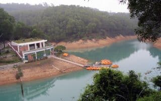
The 1.5 km trail around the Hac Sa Reservoir is a great spot on Coalane to do some off-road laps! Enjoy the water views and shaded sections. Can be combined with Hac Sa Family Trail or the runnable Hac Sa Beach.
Share your feedback on this route and see that of other Great Runs users. Click on the image icon to upload a photo. And please let us know if there are notes or changes we should incorporate!
Subscribe
0 Comments
Oldest
Newest
Inline Feedbacks
View all comments
Essentials
Depends on trail chosen
Colaone Trail is hilly - a couple of steeper sections

Review or Comment on This Route/Share a Photo!
Share your feedback on this route and see that of other Great Runs users. Click on the image icon to upload a photo. And please let us know if there are notes or changes we should incorporate!