For those who want to get in a bit of hill work and some greenery (Bukit=Hill), these three areas all within a couple of km of each other make for a good run either standalone or in combination. We’ve created a map that does the perimeter of each area and shows the best running connections between the three parks.
The Bukit Cina hillside dates back to the 15th century features a temple, burial ground, and a well. There’s a series of paths, including a fairly open path following the perimeter of the park, a loop of about 3 km. It’s a popular spot for running. Since it’s fairly open, best to avoid the heat of the day.
Bukit Serindit. Source: Wikimedia Commons
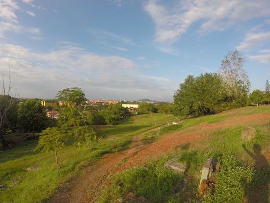
Bukit Serindit is about 1 km east of Bukit Cina. This is also a hilly area, and location of two adjacent recreational parks. There are paths for walking and running, sports fields, and small lakes. A loop around these areas could add up to 2-3 km.
From the south end of Bukit Serindit, it’s about 1 km south to St. John’s Hill, where there’s a pleasant, shaded road to St. John’s Fort, which is a good spot for hill practice! The road to get there, Jalan Ayer Leleh, is not that pretty, but it is runnable.
To return to Bukit Cina, use side roads: Lorong Tambi Abdullah 3&6, and Lorong Laksamana Cheng Ho 1. Or, use Highway the main road Route 5, which is runnable but not pleasant.
For those who want to get in a bit of hill work and some greenery (Bukit=Hill), these three areas all within a couple of km of each other make for a good run either standalone or in combination. We’ve created a map that does the perimeter of each area and shows the best running connections between the three parks.
The Bukit Cina hillside dates back to the 15th century features a temple, burial ground, and a well. There’s a series of paths, including a fairly open path following the perimeter of the park, a loop of about 3 km. It’s a popular spot for running. Since it’s fairly open, best to avoid the heat of the day.
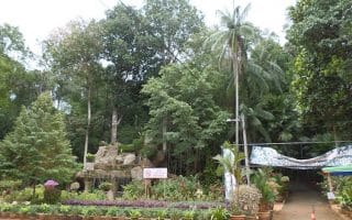
Bukit Serindit. Source: Wikimedia Commons
Bukit Serindit is about 1 km east of Bukit Cina. This is also a hilly area, and location of two adjacent recreational parks. There are paths for walking and running, sports fields, and small lakes. A loop around these areas could add up to 2-3 km.
From the south end of Bukit Serindit, it’s about 1 km south to St. John’s Hill, where there’s a pleasant, shaded road to St. John’s Fort, which is a good spot for hill practice! The road to get there, Jalan Ayer Leleh, is not that pretty, but it is runnable.
To return to Bukit Cina, use side roads: Lorong Tambi Abdullah 3&6, and Lorong Laksamana Cheng Ho 1. Or, use Highway the main road Route 5, which is runnable but not pleasant.
Scroll Down For Route Maps
Essentials
3 km (1.8 miles) loop
35m
Just off Highway 5 at Jalan Puteri Hang Li Poh Road
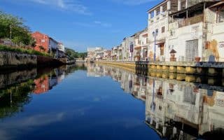
The signature running spot in Malacca. Paths run for about 7 km along the river. In the more central section, there are shops, cafes, and mural art on the walls of historic homes. Further north, the paths are more pastoral, passing fields and farms.
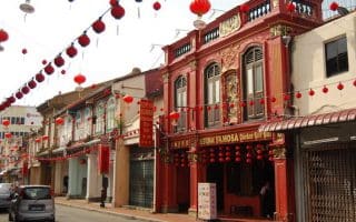
A 7km 'runseeing' tour of Malacca, using a signposted 'Heritage Walk'. The route passes many of Malacca's most important sites, key streets, and sections of the River Walk. Best to go early and beat the heat and the crowds.
For those who would like to get in some some open air and green running, we recommend heading to the Hutan Rekreasi Ayer Keroh, which is a combination nature preserve and botanical garden. It's possible to out together several km around the area's roads and trails.
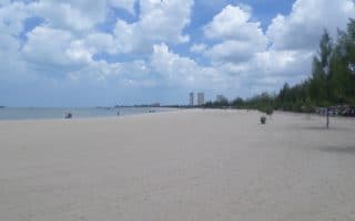
There's decent running in the 'reclamation areas' between the Encore Melaka and Tanjung Kling. A wide road with lighter traffic and a sidewalk/path goes for nearly 8 km. Kemunting Beach, 30 km west of Malacca, is scenic and good for running.
Share your feedback on this route and see that of other Great Runs users. Click on the image icon to upload a photo. And please let us know if there are notes or changes we should incorporate!
Subscribe
0 Comments
Oldest
Newest
Inline Feedbacks
View all comments
Essentials
3 km (1.8 miles) loop
35m
Just off Highway 5 at Jalan Puteri Hang Li Poh Road

Review or Comment on This Route/Share a Photo!
Share your feedback on this route and see that of other Great Runs users. Click on the image icon to upload a photo. And please let us know if there are notes or changes we should incorporate!