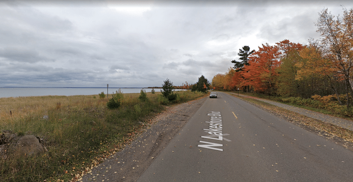
The paved multi-use path along Lake Superior is the signature run in Marquette. What’s officiall called the City Multi-Use Path runs alongside Lakeshore Blvd. for some 5 miles, from Founders Landing just south of downtown, north to Presque Isle Park. There are wonderful views of Presque Isle Harbor and the lake beyond. In sections, the path is on the opposite side of the lake.
Start anywhere on the path. The southern end is just off Lake St., a mile south of downtown. Heading north, you’ll run past the Marquette Harbor Lighthouse. At Shiras Park, there’s a short on-road section. Pick up the path again, and run as far as Presque Isle Park, at the 4.7 mile mark.
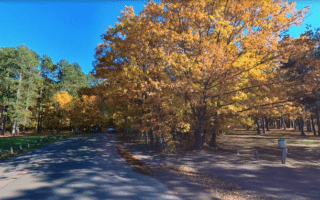
For a longer run, add the ~2 mile loop around this lovely waterfront park, along Peter White Dr. It’s mainly wooded, with occasional lake views, especially at the tip at Sunset Point.
The paved multi-use path along Lake Superior is the signature run in Marquette. What’s officiall called the City Multi-Use Path runs alongside Lakeshore Blvd. for some 5 miles, from Founders Landing just south of downtown, north to Presque Isle Park. There are wonderful views of Presque Isle Harbor and the lake beyond. In sections, the path is on the opposite side of the lake.
Start anywhere on the path. The southern end is just off Lake St., a mile south of downtown. Heading north, you’ll run past the Marquette Harbor Lighthouse. At Shiras Park, there’s a short on-road section. Pick up the path again, and run as far as Presque Isle Park, at the 4.7 mile mark.
For a longer run, add the ~2 mile loop around this lovely waterfront park, along Peter White Dr. It’s mainly wooded, with occasional lake views, especially at the tip at Sunset Point.

Review or Comment on This Route/Share a Photo!
Share your feedback on this route and see that of other Great Runs users. Click on the image icon to upload a photo. And please let us know if there are notes or changes we should incorporate!