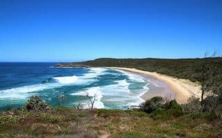
For those who don’t mind venturing a bit out of town, the Noosa Trail Network provides eight hinterland trails suitable for trail running. This area, about 30 miles from town, is a lush hinterland dotted with tranquil lakes and rainforest across rolling green valleys. There are many km of running options on this extensive network of trails. The trails, which are also popular for hiking and mountain biking, are well signposted and graded for difficulty.
This brochure and trail map has good information on the trails, with information on segment distances and elevation profiles. Helpful to print beforehand.
Add on: On your way to the trail network, stop at Mt. Tinbeerwah which is 15 minutes from Noosa Heads. A partially paved 1 km path will take you 870 feet (265 meters) above sea level and to a 360 degree view of the Noosa area and the Pacific Ocean.


Review or Comment on This Route/Share a Photo!
Share your feedback on this route and see that of other Great Runs users. Click on the image icon to upload a photo. And please let us know if there are notes or changes we should incorporate!