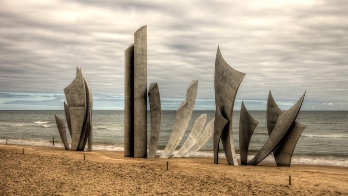
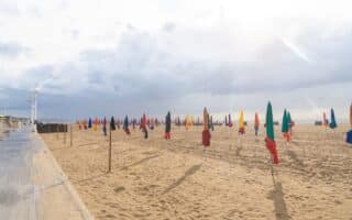
Omaha Beach, location of the Allied invasion of France on June 6, 1944 (D-Day), is an important visitor site in Normandy. On the beach itself is the “Les Braves” steel sculpture paying homage to WWII soldiers & remains of German bunkers. There’s also a D-Day Museum, a Memorial Museum, and the Normandy American Cemetery. There are some excellent running options for those visiting Omaha Beach. NOTE: Please be respectful — no running in the area of the Memorials & Cemetery.
Flickr: Mike McBey
Beachfront Path. A beachside path/sidewalk runs alongside Rue Bernard Anquetil/ Bd. de Cauvigny for 3.4 km. Great views of the beach and water. It’s an experience to run along the Av. de la Libération from the Memorial Museum to “Les Braves” sculpture on the beach and then along the path or on the beach. ROUTE MAP
Longer Options: Continue west from the end of the beachside path on the dedicated cycle path toward Pointe du Hoc. The gravel path runs above the beach, through pretty farmland. Up to 8 km one-way (Note:45m climb from beach path to bike path). Also, there’s a lovely cycle path/quiet road headed east, for 8.7 km between Colleville Sur Mer and Port-en-Bessin. This route is above the beach, and just north of the D514 (which is not good for running!). Very pretty countryside, with farm fields and views to the water. Follow the EuroVélo signs (EV4). Note: some short, steep hills. MAP
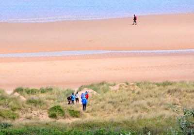
Omaha Beach. This is a great beach for running — wide, with firm sand. Although the beach itself is 10 km long, the wide section is ~8 km between the WN 60 Historical Landmark and WN 72 historical landmarks.
‘Hedgerows’ Av. Moulin. Google Street View
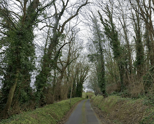
Cemetery/’Hedgerow’ Run. There’s a good network of roads around the Normandy American Cemetery that are scenic for running, providing a good sense of the hedgerows (sort of like high shoulders) and geography faced by the soldiers in 1944. We’ve mapped a 5 km route from the parking lot near WN 62. Climb 60m over 1.5 km, and run along Moulin toward Colleville Sur Mer, passing the Wash house of the nineteenth century, WN 63, and the Overlord Museum. Then back toward the beach along Rte du Cimetiere Americain, to the Visitor Center. Note: avoid the D514 road. ROUTE MAP
Interior Farm Roads. There’s a great network of quiet roads inland from the beach passing mainly by farms and fields. Create your own route on these narrow, nearly traffic-free roads. Another tip is to follow the ‘Velo’ (cycle route) signs, which are oriented toward cycle paths and lower-trafficked roads. Note: We recommend staying away from the D514, D517, & D30, which can be busier and have no shoulder.
Omaha Beach, location of the Allied invasion of France on June 6, 1944 (D-Day), is an important visitor site in Normandy. On the beach itself is the “Les Braves” steel sculpture paying homage to WWII soldiers & remains of German bunkers. There’s also a D-Day Museum, a Memorial Museum, and the Normandy American Cemetery. There are some excellent running options for those visiting Omaha Beach. NOTE: Please be respectful — no running in the area of the Memorials & Cemetery.
Flickr: Mike McBey
Beachfront Path. A beachside path/sidewalk runs alongside Rue Bernard Anquetil/ Bd. de Cauvigny for 3.4 km. Great views of the beach and water. It’s an experience to run along the Av. de la Libération from the Memorial Museum to “Les Braves” sculpture on the beach and then along the path or on the beach. ROUTE MAP
Longer Options: Continue west from the end of the beachside path on the dedicated cycle path toward Pointe du Hoc. The gravel path runs above the beach, through pretty farmland. Up to 8 km one-way (Note:45m climb from beach path to bike path). Also, there’s a lovely cycle path/quiet road headed east, for 8.7 km between Colleville Sur Mer and Port-en-Bessin. This route is above the beach, and just north of the D514 (which is not good for running!). Very pretty countryside, with farm fields and views to the water. Follow the EuroVélo signs (EV4). Note: some short, steep hills. MAP
Omaha Beach. This is a great beach for running — wide, with firm sand. Although the beach itself is 10 km long, the wide section is ~8 km between the WN 60 Historical Landmark and WN 72 historical landmarks.
‘Hedgerows’ Av. Moulin. Google Street View
Cemetery/’Hedgerow’ Run. There’s a good network of roads around the Normandy American Cemetery that are scenic for running, providing a good sense of the hedgerows (sort of like high shoulders) and geography faced by the soldiers in 1944. We’ve mapped a 5 km route from the parking lot near WN 62. Climb 60m over 1.5 km, and run along Moulin toward Colleville Sur Mer, passing the Wash house of the nineteenth century, WN 63, and the Overlord Museum. Then back toward the beach along Rte du Cimetiere Americain, to the Visitor Center. Note: avoid the D514 road. ROUTE MAP
Interior Farm Roads. There’s a great network of quiet roads inland from the beach passing mainly by farms and fields. Create your own route on these narrow, nearly traffic-free roads. Another tip is to follow the ‘Velo’ (cycle route) signs, which are oriented toward cycle paths and lower-trafficked roads. Note: We recommend staying away from the D514, D517, & D30, which can be busier and have no shoulder.
Scroll Down For Route Maps
Essentials
Sidewalk along beach is 3.4 km; Beach itself is 8+ km. Our 'hedgerow' route is 5 km.
Beach is flat. There are some hills coming up from the beach
Depends on route chosen
Numerous visitor centers and parking lots in the area
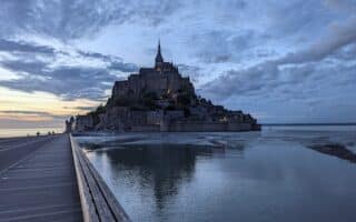
Running on the road approaching Mont Saint-Michel is a memorable experience. Fantastic views of the Abbey of Saint-Michel and surrounding coastal plain. Can add coastal spots around the Mont at low tide. Additional paths along the Couesnon River.
A great run with lots of variety in this historic, fortified town: Old Port & jetty, headland, medieval Upper Town, and beach/waterfront promenade. Hills, views, scenery & history! Running track off Rue de Roc.
The best running options in Bayeux are just outside of town: Vélo routes through the quiet Norman countryside; a cycle path along the D6; and in Port-En-Bessin and a beautiful path headed west toward Colleville-sur-Mer.
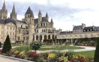
Our 10k 'runseeing' tour of Caen includes its famous Caen Castle, two iconic Abbeys, and other key sites. There's also a nice path along the Orne River for 3.5 km and a gravel path along the Canal de Caen a la Mer for up to 14.5 km to the sea.
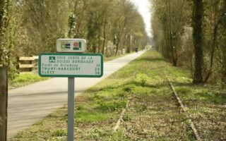
Lovely countryside in the Orne Valley. Best running option is to choose a section of the Vois Verte de la Suisse Normande, a multi-use path that runs from just south of Caen to Thury-Harcourt, following the Orne. Rolling hills, forests, open spaces.
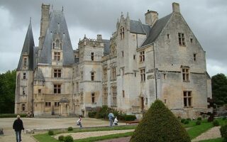
Run the grounds of the most spectacular château in Normandy, located 14 km from Caen. One can do 3-4 km on paths around the Château's forests and gardens, or a longer tour that includes the Mue Valley's lovely landscape and the Château de Thaon.
Great running in this upscale seaside resort. Two great routes that can be run separately or combined are the 3 km promenade along Deauville Beach and a loop around Port-Deauville, including riverside paths and a promenade along Trouville Beach.
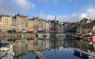
Lovely running in this charming town where the Seine meets the Channel. There's 12 km of riverfront paths, and paths around the picturesque harbor. Honfleur Beach is also great for running. Can also run across the Normandy Bridge to Le Havre!
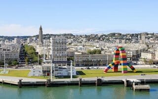
An enjoyable 'runseeing' tour of France's second-largest port city, including the lighthouse, 2.5 km seafront promenade, paths around the port, and a jaunt through the city center. Can also run across the Normandy Bridge to Honfleur.
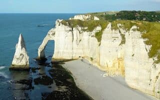
Running along the bluff of the white limestone cliffs of Étretat is one of the great running experiences in Normandy. Open windswept landscape, with dramatic views of the sea, the cliffs, and fields. The easier direction is headed east.
Nice running in this popular seaside resort. One can do a ~7 km waterfront run around the marina and along a beach promenade. There's also a nice run on the Promenade de Cap Fenet, which can be done separately or combined with the waterfront route.
A terrific 'runseeing' tour of this port and seaside resort city. Includes path along the marina, 1.5 km seafront promenade, the Château de Dieppe, and a jaunt through the city center.
Rouen is well-known for its picturesque old town, Cathédrale Notre-Dame, and Museum of Fine Arts. The best place to run is on paths along the Seine River. Up to 8 km between the Gustave-Flaubert Bridge and the Pierre Corneille Bridge.
The folks at Rouen Tourism have mapped two scenic routes incorporating historic manors and castles near Rouen, including some sections along the Seine and in the agricultural countryside.
Use this as an overview of Normandy's four huge regional parks. Those that are closest to our coastal routes are Boucles de la Seine and Marais du Cotentin et du Bessi. Vast opportunities for running on quiet rural roads, hiking trails, and cycle paths.
Share your feedback on this route and see that of other Great Runs users. Click on the image icon to upload a photo. And please let us know if there are notes or changes we should incorporate!
Subscribe
0 Comments
Oldest
Newest
Inline Feedbacks
View all comments
Essentials
Sidewalk along beach is 3.4 km; Beach itself is 8+ km. Our 'hedgerow' route is 5 km.
Beach is flat. There are some hills coming up from the beach
Depends on route chosen
Numerous visitor centers and parking lots in the area


Review or Comment on This Route/Share a Photo!
Share your feedback on this route and see that of other Great Runs users. Click on the image icon to upload a photo. And please let us know if there are notes or changes we should incorporate!